Hammock Camping in a Flooded Forest

Join me for 3 days of Hammock Camping, Backpacking and Camp Cooking in the Wetlands of South Carolina.

For this off the beaten path backpacking trip, I headed down to South Carolina’s lone National Park. Located roughly 100 miles west of coastal Charleston, South Carolina, Congaree National Park is a dense wetland providing a rich habitat for dwarf palmettos, towering loblolly pines, cypress trees, wild hogs, owls, bobcats, and even the occasional alligator.

While often referred to as a swamp, Congaree National Park is actually a floodplain old growth bottomland hardwood forest.  With an average canopy height in excess of 100 feet, it’s the tallest deciduous forest in the world.  To put that in perspective, that’s taller than even the Amazon Rainforest.

For sleep and shelter I packed in a new hammock with integrated bottom insulation, a 40 degree top quilt to deal with the unseasonably cold winter temps, and my ultralight backpacking tarp. According to the forecast, I would most likely be able to skip the tarp, but I still brought it along as a backup, just in case some rain popped up at night.

My backpacking food consisted of some “real” food for camp cooking, a handful of typical backpacking snacks, and a military issued surplus MRE (meal ready to eat) for a little variety and fun.

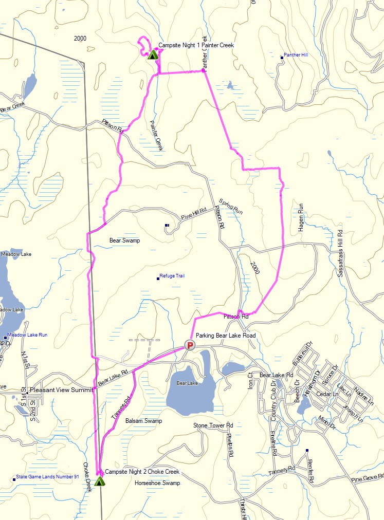
A free permit is required for backcountry camping in Congaree National Forest, and you must specify a specific zone for each night.  To keep things interesting, I chose Zone 9 for both nights. In addition to being the largest zone, a unique thing about Zone 9 is that it has no actual trails.  This allowed be to do a bit of a “choose your own adventure” experience.  I could explore and navigate freely based on the everchanging flood zones in Congaree NP as came across them.

I had a rough plan to set up camp at a historical site know as Cooner’s Cattle Mount if I could find it.  I saw this listed on an old map, but information was scarce online. In fact,  the South Carolina Department of Archives and History report actually redacted the actual site location.  Luckily, I could simply camp wherever else I saw fit if I didn’t manage to find it.

I also used some LIDAR maps (also known as “Shaded Relief Maps” on Caltopo) to do a little historical scavenger hunting on this trip.  LIDAR is a form of ground penetrating radar that allows you to see through the trees to identify anomalies on the ground such as water flows, unnamed trails, and even the remnants of long forgotten structures.

Trailhead Used
Kingsnake Trailhead
Gadsden, SC 29052
33°49’09.7″N 80°47’16.2″W

While not actually located in Zone 9, the Kingsnake trail offers a gravel parking area and convenient access to Zone 9 after hiking south for a couple of miles or so.

Season / Time of Year
Winter – February

FTC Disclosure: This post contains affiliate links, which means I may receive a commission for purchases made through some of my links.

Notable Backpacking Gear Used on this Trip

Facing the Elements: Joshua Tree Backpacking in a Rain Storm

Join me for 3 days of Backpacking, Hiking and Desert Camping in the Rain while  exploring California’s Joshua Tree National Park.

For this winter desert camping adventure, I decided to do a solo backpacking trip in Southern California’s Joshua Tree National Park.  I chose the Maze zone as my primary area of exploration, with the added possibility of hiking along the storied Boy Scout Trail as well.

Due to backcountry camping permit regulations, I chose to obtain a permit for camping within the Maze Zone, with the possibility of hiking into and exploring the Boy Scout Zone by day.  This was mostly due to the fact that the Boy Scout Zone is the only JNP zone that requires you to specifically get a permit for 1 of 8 specific campsites, and I wanted to have some more flexibility to choose my campsites on the fly.

Getting a permit for the Maze zone allowed me to camp anywhere I wanted as long as I was at least 1 mile from an official trailhead, one half mile from any road, and 200 feet from any trail.  Prefect – that sounded like exactly the solitude I was looking for.

Being February in the Mojave Desert, my expected temperature range would be from roughly 40 to 75 degrees or so.  What about rain, you ask?  Well, 336 days out of the year, the answer would be a solid – “No need for rain gear over here!”.  I apparently arrived on one of those 29 other days.  No worries though. I think it provided a pretty unique opportunity to see the Mojave Desert during one of it’s most vital times for survival of plants and animals in this arid environment – a desert rain storm curtesy of El Niño.

For sleep and shelter, I packed in my Outdoor Vitals Fortius trekking pole tent, a 3-season sleeping pad and my Hammock Gear 40° down quilt.  Reliable drinking water is pretty much non-existent in Joshua Tree National Park regardless of the season, so I was tasked with packing in all of my drinking water for the entire 3 day trip.  For this reason, I decided to skip the usual dehydrated backpacking meal choices in favor of some cheap and easy ready to eat food options.

I also opted to ditch the stove and just go the no-cook backpacking food route, because why not?   Honestly, my pack was jammed to the hilt with water, and I just wasn’t in the mood to carry more fuel and cooking supplies.

Route Overview – Smoky Mountains Little River Gorge Backpacking Loop – Sintax77

A permit is required for backcountry camping in Joshua Tree National Park.  You can reserve them on the Joshua Tree National Park website here.

Full GPS track data, including campsites, water sources, etc, for this trip and many others can be downloaded on my Trip Data Page.

Continue reading

My Wife Dropped me at the Mexican Border – Yuma County Backpacking

3 Days of Desert Camping and Backpacking in Yuma County Arizona.

For this backpacking trip, I headed even farther south to a remote corner of Arizona not too far from border with with Mexico in an area known as the Kofa Wilderness.

For sleep and shelter I brought an ultralight trekking pole tent, 3-season inflatable sleeping pad, and a 40 degree sleeping bag, as the forecasted temperature range for this December adventure would range fro highs in the eighties down to as low as the upper 30’s depending on wind conditions and where I chose to set up camp in the vast array of mountains and valleys found in this corner of the American Southwest.

My choices for camping food on this backpacking trip would be pretty simple – mostly because there are no reliable water sources in this desolate sampling of the Sonoran Desert. Since I would have to pack in and carry all of my own drinking water from the start, there was little reason to spend money and effort on traditional dehydrated backpacking meals.

Instead I chose to hit the local dollar store for some calorie dense, if not nutritionally diminished, food sources. The end result? 3 days worth of calories for under twenty bucks, and no water or stove required. …there will plenty of opportunities to eat salad back in civilization. If I manage to get back there…

Trailhead Used:
King Road Access, 1/4 mile north of Yuma Customs Checkpoint on AZ Rt 95

Trails Used, Day 1

  • Horse Tanks Jeep Trail
  • None

Trails Used, Day 2

  • None
  • Random animal trail (?)
  • None

Trails Used, Day 3

  • None
  • Kofa Horse Tanks
  • None
  • King Road


Backpacking the Smoky Mountains – Wind, Rain & Solo Camping

Join me for 3 days of Winter Camping, Backpacking & Hiking in the Smoky Mountains. 

For this winter camping adventure, I decided to do a solo backpacking loop along the Little River Gorge in Tennessee’s western region of Great Smoky Mountains National Park.  The Little River is flanked to the south by Meigs Mountain and to the north by Sugarland Mountain.  By hiking trails along the ridges of both these mountains, I was able to create a 25 mile loop with 6,000 feet of gross elevation gain.

On the first night, I chose to camp on top of Meigs Mountain at campsite 19, Upper Henderson.  On day two I planned to descend into the gorge to camp along the Little River at campsite 21. On the third day, I would hike up Sugarland Mountain towards Laurel Falls and ultimately, Little Brier Gap to complete the loop.

For sleep and shelter, I packed in my Outdoor Vitals Fortius trekking pole tent, a 3-season sleeping pad and my Hammock Gear 20° down quilt.  Despite it being the middle winter, my temp range was relatively mild with lows in the 40’s and highs touching the mid 60’s.  This allowed me to leave my extra cold weather clothing layers at home, so I was still able to use my ultralight backpack instead of the larger pack that I typically use for winter.  Days 2 and 3 had a forecast of rain and high winds, so I played it safe and packed in full set rain gear as well.

Route Overview – Smoky Mountains Little River Gorge Backpacking Loop – Sintax77

A backcountry permit is required for all campsites in this area. You can reserve them for $8 per night on the Smoky Mountains National Park website here.

Full GPS track data, including campsites, water sources, etc, for this trip and many others can be downloaded on my Trip Data Page.

Continue reading

3 Days Winter Camping with NO STOVE – Cooking with Fire!

3 Days of Winter Camping, Backpacking & Campfire Cooking in Pennsylvania’s Pinchot State Forest.


FTC Disclosure: This post contains affiliate links, which means I may receive a commission for purchases made through some of my links.

For this late winter backpacking trip, I decided to challenge myself to cook “real food” using only fire for the duration of my trip. If you know anything about my patience for making fires, you’ll know this will truly be a bit of a challenge. 🙂

For shelter, I went with my minimalist camping hammock and ultralight backpacking tarp set-up. I also utilized a grill grate, a folding saw for harvesting campfire wood, and some extra cold weather clothing layers, as the temps were forecasted to head down to  around 15° F or so. There was also a chance of snow, sleet, and even rain, so I brought a full set of rain gear for warmth at camp and keeping dry while hiking.

Full Route Overview – Pinchot Trail North Backpacking Loop – Sintax77

Continue reading

3 Days of Campfire Cooking and Hammock Camping – Harpers Ferry West Virginia

Hammock Camping, Trail Cooking and the search for an Elusive Hearth in the Woods of West Virginia.

FTC Disclosure: This post contains affiliate links, which means I may receive a commission for purchases made through some of my links.

For this early February hammock camping trip, I set out to hike a 3 day hike with a nostalgic goal – to find a giant campfire hearth that my friend and I had built five years ago, somewhere off of the Appalachian Trail near the town of Harpers Ferry, West Virginia.  I had always wondered if it was still standing after all these years, and thought it would be a great excuse to spend some time in the woods a cook some hearty camping meals.

My weather conditions were forecasted to have a pretty wide range during this trip, from the upper 50’s down to 30 degrees each evening.  I had a rough idea of the hearth’s location.  We built it at camp not too long after leaving the Harpers Ferry National Historic Area’s boundary while heading south on the Appalachian Trail.  My goal for the first day was to get myself to a legal camping area in this general area so I could search for it first thing the next morning.  If I found it early, I would then have the option to do a day hike to Loudoun Heights and Split Rock for views of the Shenandoah River and Potomac River below the ridge.

For sleep and shelter on this trip, I went with a simple hammock camping and ultralight tarp setup (gear list below).  I used the extra space in my winter backpack to load up on extra clothing layers, a saw for harvesting firewood, a stool for working in my makeshift camp kitchen, and my white gas stove system paired up with a fry pan and diffuser to try my hand at baking some trail bread at camp.  The cooler temps also allowed me to bring some “real” food, so I brought along some ingredients to make some smoked sausage one day and pasta with a slow cooked meat sauce the next.

This trip video was sponsored by Anker and their model 521 and 535 Portable Power Station.

Route Overview – Harpers Ferry Loudoun Heights Winter Backpacking Trip – Sintax77

Full GPS track data, including campsites, etc, for this trip and many others can be downloaded on my Trip Data Page.

Continue reading