Escape Your Comfort Zone: Backpacking Mount Rushmore

4 Days of Solo Backpacking, Hiking & Camping in the Black Hills of South Dakota.

For this late summer backpacking adventure, I decided check out two places I had never been to before – the Mount Rushmore Memorial and the adjacent Black Elk Wilderness within the Black Hills National Forest.

I was surprised to discover that there’s actually a trailhead right at the base of Mount Rushmore, so it seemed like to perfect opportunity to create a unique backpacking experience.

Speaking of those looming presidential faces, I should make an important point – While the Mount Rushmore statue, parking lot and visitor center, etc. is a National Memorial  (managed by the National Park Service), the surrounding area is National Forest, so dispersed camping is all good!

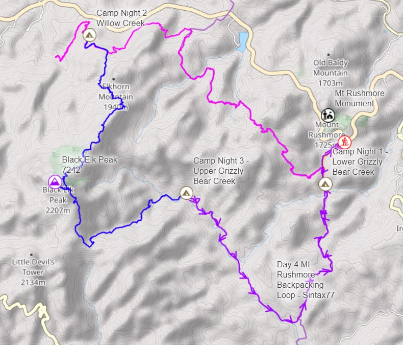
With that in mind, I mapped out a roughly 30 mile hiking loop using the available trails, packed my tent, sleeping pad and some backpacking food into my backpack, and got a ride from my wife to the trailhead.

Due to the close proximity to the National Monument, the trailhead parking lot is closed off to overnight parking. This probably makes this a lesser used starting point for backpackers, but it’s well worth it if you have someone nice enough to drop you off and pick you up after a few days of camping in the Black Elk Wilderness.

Route Overview – Mt Rushmore Black Hills Backpacking Loop – Sintax77

Full GPS track data, including campsites, water sources, etc, for this trip and many others can be downloaded on my Trip Data Page.

Continue reading

Beginner Backpacking – Campfire Cooking & Abandoned Hotels on Echo Lake

3 Days of Camping and Backpacking on Echo Lake in the Catskill Mountains.

FTC Disclosure: This post contains affiliate links, which means I may receive a commission for purchases made through some of my links.

For this backpacking trip, we headed up to New York’s Catskill Mountains for 3 days of campfire cooking, mountaintop abandoned hotel exploration and lakeside camping with crew consisting of a wide range of experience levels – all the way from 10 years to a very first backpacking trip.

Our Late Fall temperature range for this trip was between 35° and 70° without a chance of rain until the latter half of the trip.  With the possibility of rain on our last day hike out, and the addition of some fun comfort items like a stool, firewood saw and some other surprise goodies, my base weight was a little over my typical sub-10lb base weight for this particular trip.

Mike and I went with hammock camping setups for this backpacking trip, while Mike’s son and his friend decided to share a Nemo 3 person tent. Our  plan was to do our 3 day trip basecamp style by snagging a decent campsite alongside Echo lake and remaining there for both nights.  This would allow us to do a day hike up towards Indian Head Mountain on the ridge lighter daypacks.  This also gave us the advantage of returning to a campsite that was already setup if our hike back ended up taking longer than expected.

Water would be plentiful at basecamp due to the nearby lake, but their is beaver activity in the area, so water filtration and / or treatment is strongly encouraged.  There is also a stream that feeds the pond not to far from where the spur trail for the Echo Lake Shelter begins.  Our chosen campsite was on the opposite side of the lake, so went the filtration route with my Katadyn BeFree water filer system.

Full GPS track data, including campsites, etc, for this trip Sintax77 and many others can be downloaded on my Trip Data Page.
Continue reading

Summer Backpacking – Fog, Rain & Shelter on the Old Loggers Path

3 days of Backpacking, Trekking Pole Tent Camping and Lean-to Shelter Camping on the Old Loggers Path.

FTC Disclosure: This post contains affiliate links, which means I may receive a commission for purchases made through some of my links.

For this 3 day, 2 night summer backpacking trip, I decided to revisit the OLP in Pennsylvania’s Loyalsock State forest.  The OLP is a 27 mile backpacking loop along babbling brooks, waterfalls, hardwoods and hemlocks. I previously did this loop counter-clockwise as a solo hike a couple of years ago, but there was so much to soak in that I decided it would be worth hiking it again. This time I would hike it clockwise with my buddy Dave from Outdoor Vitals, who recently moved out to Pennsylvania from Utah.

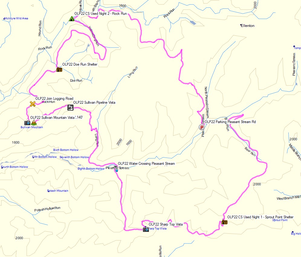
Dave had never camped in a lean-to shelter before, so we targeted the Sprout Point shelter for our first night, followed by some tent camping along the confluence of Rock Run and Yellow dog run on the second night.  This would also be my first time experimenting with an ultralight trekking pole tent, so I was looking forward to trying that out.

Our weather ranged from highs in the upper 70’s with fairly high humidity, and lows in the upper 60’s.  This allowed me to save weight by packing a lightweight 40° quilt and leaving my extra warm clothing layers at home.  There was a possibility of rain each day though, so I packed in full rain gear. I also brought a folding saw and some other comfort items, so my base weight was still right around 10 lbs despite the warm forecast.

Trail conditions on the OLP are a mix of nice flat dirt sections, punctuated by spurts of steep sections littered with Pennsylvania’s infamous rocks to keep you on your toes ; literally.  Despite the occasional rough sections, the average daily gross elevation gain was only around 1,500 feet per day. Potential water sources are fairly plentiful on the Old Loggers Path, but the key word is potential. When I went before in spring, I got by with only carrying around 1 liter of water at a time.  This time around things were very dry, so the only water sources we used were the two that are always flowing – Pleasant Valley Stream and the Rock Run / Yellow Dog Run confluence.

Route Overview – Old Loggers Path Clockwise Backpacking Loop – Sintax77

Continue reading

Camping in Heavy Rain – Pinchot Trail South Loop Backpacking Trip

Join Sara and I for some Spring Backpacking, Camping in the Rain, and Trail Cooking on the Pinchot Trail southern loop.


FTC Disclosure: This post contains affiliate links, which means I may receive a commission for purchases made through some of my links.

For this early spring camping trip, my wife Sara and I set out to do some backpacking  with our dog and explore Pennsylvania’s Pinchot Trail southern loop.  I had done the northern loop a couple of weeks before and it was quite nice, so I was looking forward to seeing what this new section had to offer.

For shelter, we packed in our 4 person tent as well as a huge tarp to give us some extra living space during the rain storm that was forecasted to hit in the afternoon and turn into snow by the next morning.

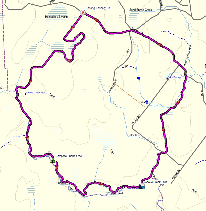
The bottom of the Pinchot Trail South loop runs along Choke Creek, which offers a string of 6 or so beautiful waterside campsites over the course of a mile or so. Legend has it that the last of those campsites is the most picturesque, so our goal was to hike in a few miles to the creek and get to that coveted campsite before the afternoon rain started. If the weather broke early, we would aim to take one of the earlier campsites.

Route Overview – Pinchot Trail South Backpacking Loop – Sintax77

Continue reading

Winter Camping on Mt Washington – Deep Snow, Below Zero

Backpacking & Winter Camping on the side of Mount Washington.

FTC Disclosure: This post contains affiliate links, which means I may receive a commission for purchases made through some of my links.

For this adventure, I headed back up to the White Mountains of New Hampshire to do some snow camping and make another attempt at doing a Mt Washington winter ascent for some frozen views of the Presidential Range.  I tried this about a year ago, but a stomach bug and 85 MPH winds kind of put a damper on things.  This time around, I also brought a hiking partner, Frank.  We’ve done several winter trips together so far, but this would be his first time in the White Mountains.

Similar to last year’s trip, the plan was to set up a base camp at higher elevation, followed by a lighter weight trek up to the top of Mount Washington if weather conditions and visibility were agreeable. If the conditions were questionable, we made a back-up plan to scurry up the side of the nearer Mt Monroe.  And of course, if the weather really got bad, we would just play it safe and stay below tree line.

Trailhead Used: Ammonoosuc Ravine Trailhead
44°16’01.2″N 71°21’40.7″W
Base Station Rd, Jefferson, NH 03538

This is a large parking lot with room for many vehicles.  A parking fee of $5 dollars per day or an annual National Park pass is required.

Trails Used

  • Ammonoosuc Ravine Trail
  • Appalachian Trail (Crawford Path)
  • Mt Monroe Loop Trail

Campsite

  • Camp along Ammonoosuc Trail 44.26398, -71.32182
    • This was a small unofficial campsite located in a hollowed out spot not too far before entering the Lakes of the Clouds Forest Protection Zone.

Notable Backpacking Gear

Camera and Nav Gear used for this episode

Winter Camping in Pennsylvania’s Most Remote Forest

Backpacking, Hiking & Winter Tent Camping with Snow in Pennsylvania’s Hammersley Wild Area.

FTC Disclosure: This post contains affiliate links, which means I may receive a commission for purchases made through some of my links.

For this early December backpacking trip, I set out to hike a 3 day, 20ish mile loop in the mountains of north central Pennsylvania.  I created my loop by using a portion of the Susquehannock Trail System, some off-trail bushwhacking, and a ridge hike along the adjacent Twin Sisters Trail.

My weather conditions were forecasted to have some fresh snow, temps mostly in the 20’s and a potential for freezing rain as the temps rose further into the trip.  While this was a pretty wide range of possible conditions, it also wasn’t terribly cold, so I was still able to pack somewhat ultralight and minimal.  My camping target for day one was down in the hollow along the banks of Hammersley Fork. On day two I planned to head up to the ridge and camp in the area devoid of trees due to a forest fire back in 1962.  Due to the potential lack of trees, I swapped out my typical hammock setup for a single person tent and sleeping pad to keep my campsite options flexible.

The Hammersley Wild Area is the most remote swath of public land in Pennsylvania, with some spots over 5 miles from the nearest road, which combined with the season, I hoped would make for some rather secluded camping.  Conversely, this area is also a haven for public hunting, so I made sure to wear some blaze orange and remain somewhat quiet and on the trail until I got further away from any road access, as it was the middle of PA deer hunting season.

This trip video was sponsored by Dr Prepare. You can get 10% off their 178Wh Portable Power Station by using code STDP10 with this link.

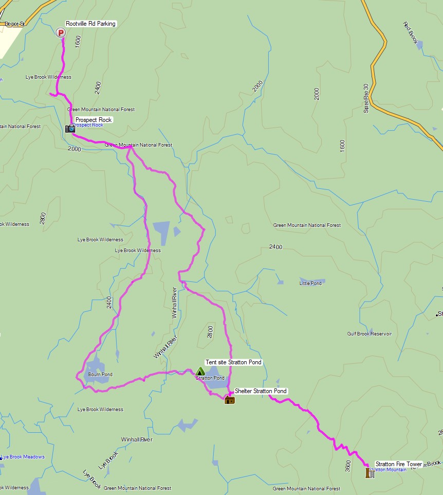
Route Overview – Stratton Pond Vermont Backpacking Loop – Sintax77

Full GPS track data, including campsites, etc, for this trip and many others can be downloaded on my Trip Data Page.
Continue reading