Winter Camping on Mt Washington – Deep Snow, Below Zero

Backpacking & Winter Camping on the side of Mount Washington.

FTC Disclosure: This post contains affiliate links, which means I may receive a commission for purchases made through some of my links.

For this adventure, I headed back up to the White Mountains of New Hampshire to do some snow camping and make another attempt at doing a Mt Washington winter ascent for some frozen views of the Presidential Range.  I tried this about a year ago, but a stomach bug and 85 MPH winds kind of put a damper on things.  This time around, I also brought a hiking partner, Frank.  We’ve done several winter trips together so far, but this would be his first time in the White Mountains.

Similar to last year’s trip, the plan was to set up a base camp at higher elevation, followed by a lighter weight trek up to the top of Mount Washington if weather conditions and visibility were agreeable. If the conditions were questionable, we made a back-up plan to scurry up the side of the nearer Mt Monroe.  And of course, if the weather really got bad, we would just play it safe and stay below tree line.

Trailhead Used: Ammonoosuc Ravine Trailhead
44°16’01.2″N 71°21’40.7″W
Base Station Rd, Jefferson, NH 03538

This is a large parking lot with room for many vehicles.  A parking fee of $5 dollars per day or an annual National Park pass is required.

Trails Used

  • Ammonoosuc Ravine Trail
  • Appalachian Trail (Crawford Path)
  • Mt Monroe Loop Trail

Campsite

  • Camp along Ammonoosuc Trail 44.26398, -71.32182
    • This was a small unofficial campsite located in a hollowed out spot not too far before entering the Lakes of the Clouds Forest Protection Zone.

Notable Backpacking Gear

Camera and Nav Gear used for this episode

Hammock Camping on the Six Husbands Trail

Hammock Camping and Solo Backpacking in the White Mountains of New Hampshire

FTC Disclosure: This post contains affiliate links, which means I may receive a commission for purchases made through some of my links.

For this adventure, I decided to get back to my ultralight backpacking roots with a rugged 27 mile loop through the Great Gulf Wilderness, Dry River Wilderness, and Presidential Range, with a gross elevation gain of around 8,400 feet. The centerpiece of my loop would be the Six Husbands Trail, a trail that some say is the most difficult in the White Mountain National Forest. Now , if you’re familiar with the WMNF, you probably know that just about every trail is pretty intense, so this could get interesting…

For sleep and shelter, I went with my standard minimalist hammock camping setup consisting of a 10 oz hammock, 5 oz tarp, and a pair of 40° down quilts.  This got my base weight down to around 7 lbs. A full gear list can be found at the bottom of this post.

The Six Husbands Trail was Built from 1909 to 1910 by trail builder Warren W. Hart of the Appalachian Mountain club. Hart was known to build his trails specifically with adventure in mind, and this trail was no exception. It begins deep in the Great Gulf Wilderness at the junction with Wamsutta Trail, which along with the connected Alpine Garden trail is actually just the renamed southern portion of the Six Husbands trail. Wamsutta was one the six husbands of female Indian Chief, Weetamoo, who has a nearby waterfall named after her.

White Mountains Six Husbands Backpacking Loop – Route Overview – Sintax77

Continue reading

Summit Fever – Winter Camping on the Presidential Range

Solo Winter Backpacking & Snow Camping in an attempt to Summit Mount Washington.

FTC Disclosure: This post contains affiliate links, which means I may receive a commission for purchases made through some of my links.

For this adventure, I headed up to the White Mountains of New Hampshire to do some snow camping with the goal of doing of a Mt Washington winter ascent.  My plan was to set up a base camp at higher elevation, followed by a lighter weight trek up to the top of  Mount Washington.

I went with a tent for shelter on this trip because I originally planned for the possibility of camping above treeline.  I had never done that before, but the weather forecast was rather good before I left home, so this seemed like a good opportunity to give it a go.  The Presidential Range had other ideas…

No permit is required to backcountry camp in the White Mountain National Forest, but a parking fee is required in some areas.

Trailhead Used: Jewell Trail Trailhead
44°16’01.2″N 71°21’40.7″W
Base Station Rd, Jefferson, NH 03538

This is a large parking lot with room for many vehicles.  A parking fee of $5 dollars per day or an annual National Park pass is required.

Notable Backpacking Gear

Camera and Nav Gear used for this episode
Hiking the Ultimate White Mountains Backpacking Loop

3 Days of Hammock Camping, Hiking & Backpacking on the White Mountains Presicat Loop.

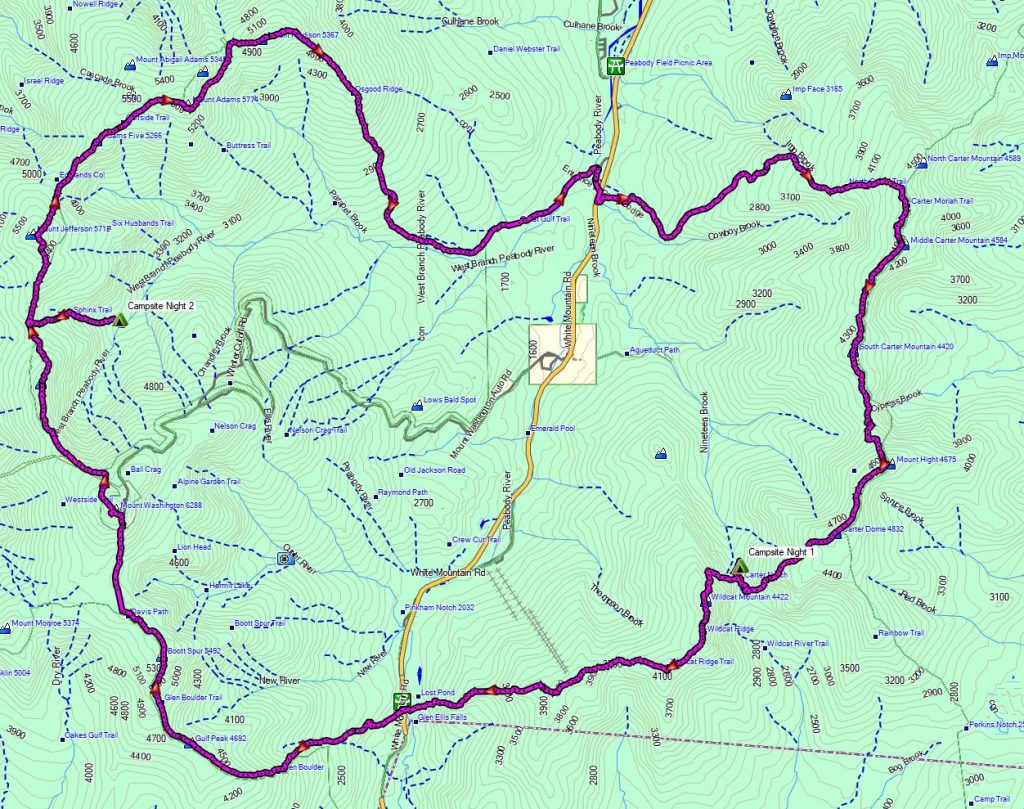
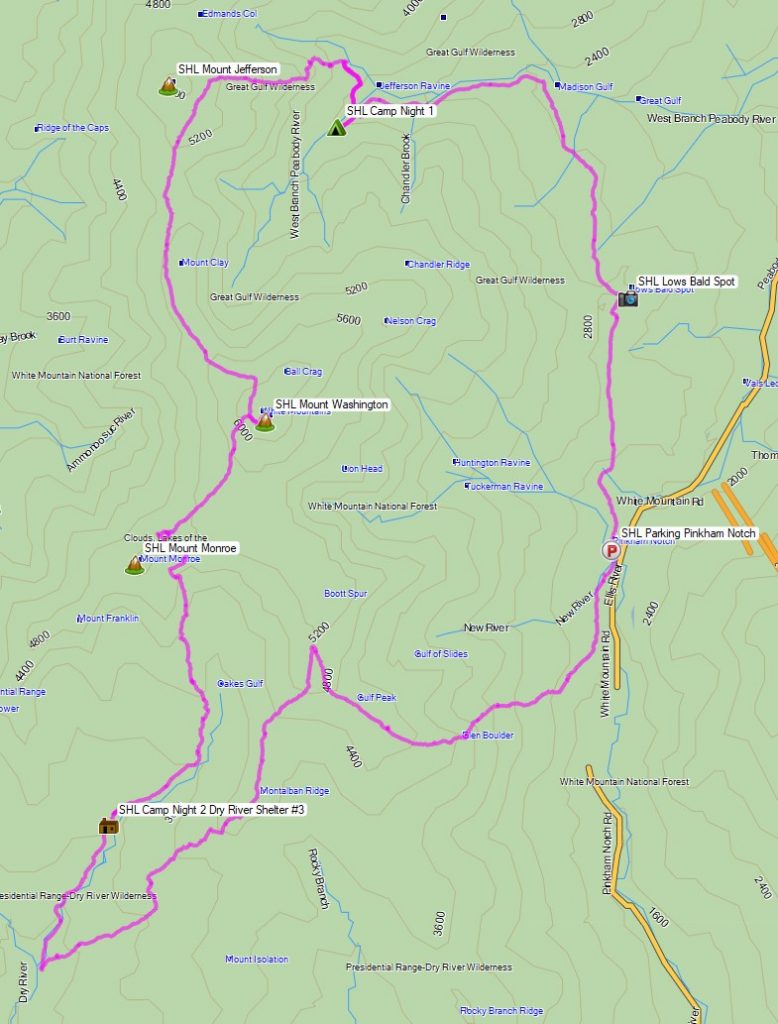
For this 3 day, 2 night summer backpacking trip, I’ll be hiking a 30 mile backpacking loop in New Hampshire’s White Mountain National Forest.  I call this the Presicat loop because it’s comprised of the Carter Range and Wildcat Range on one side, and the northern section of the Presidential Range on the other.

This route creates a grand tour of the northern White Mountains with a section of the Appalachian Trail and Mt Washington as it’s centerpiece.  Along the way we’ll hit 9 major summits (NH48’s) and 8 subsidiary peaks, while racking up 15,228 feet of elevation gain on some pretty rugged trails.

For sleep and shelter I chose a minimalist ultralight hammock camping system. This allowed me to get my base weight down to 9 lb.  Notable gear can be found in the gear section below. Or check out my full printable list with weights and links on LighterPack.

Presicat Loop Route Overview 2019 – Sintax77

No permit is required to camp in the White Mountains, but the trailhead I chose did require a self payment of $3 per day. Rules and regulations regarding backcountry camping can be found on the USFS website here.

Full GPS track data, including campsites, water sources, etc, for this trip and many others can be downloaded on my Trip Data Page.

Continue reading

That Time I Hiked with a Broken Face – Backpacking the Great Gulf Wilderness

Join TJ & I for 3 days of hiking, camping & backpacking in New Hampshire’s Great Gulf Wilderness.  Oh, & I also fall on my face.  

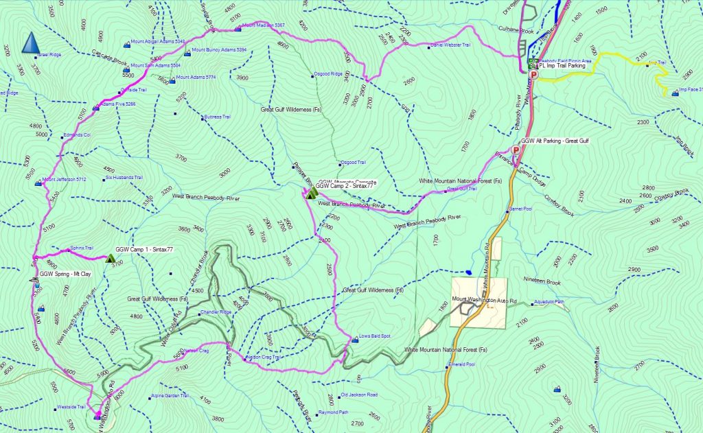
For this adventure, we’ll be revisiting an attempt at a hike that I originally did as a solo backpacking trip a few years back.  A rather aggressive loop, chalking up 30+ miles and over 15,000 feet gross elevation gain, the plan was to give it another go while giving TJ an ultimate sampler platter of the White Mountains.  As fate would have it, things would corkscrew towards another outcome…

Great Gulf Loop Route Overview - Sintax77

Great Gulf Loop Route Overview – Sintax77

Trailhead Used: Imp Trailhead on Rt 16 – N44° 19.408′ W71° 13.016′

Full GPS track data and waypoints for various POI’s on this trip are available for download on the Trip Data Page.

Trails Used, Day 1 (in order)
Road hike north on Rt 16 to Dolly Copp Campground
Daniel Webster Scout Trail
Appalachian Trail South
Sphinx Trail
Camp along Sphinx Trail, just before junction with Great Gulf Trail

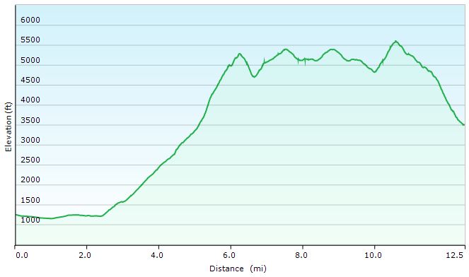
Great Gulf Loop Day 1 Elevation Profile - Sintax77

Great Gulf Loop Day 1 Elevation Profile – Sintax77

Day 1 Mileage: 12.5 miles
Day 1 Gross Elevation Gain: 6,661′

Trails Used, Day 2 (in order)
Double back on Sphinx Trail
Appalachian Trail South
Trinity Heights Connector to Summit of Mt Washington
Have a Chili Dog at the Summit
Nelson Crag Trail
Appalachian Trail South
Great Gulf Trail
Camp near Gulf Trail along ridge

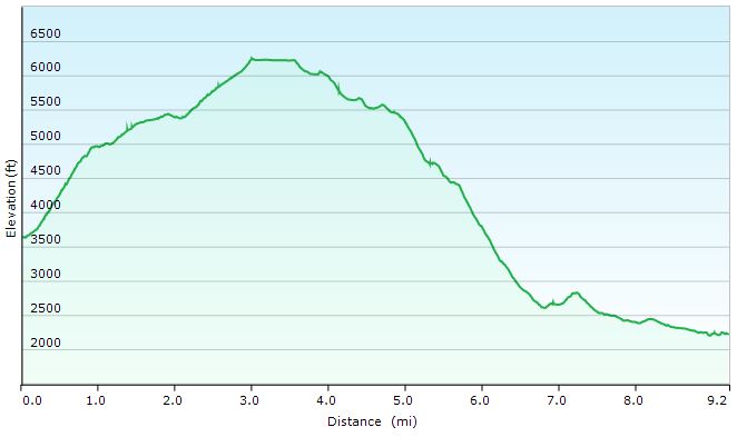
Great Gulf Loop Day 2 Elevation Profile - Sintax77

Great Gulf Loop Day 2 Elevation Profile – Sintax77

Day 2 Mileage: 9.2 miles
Day 2 Gross Elevation Gain: 3,658′

Trails Used, Day 3 (in order)
Great Gulf Trail
Short road hike back to car parked at Imp Trail Head

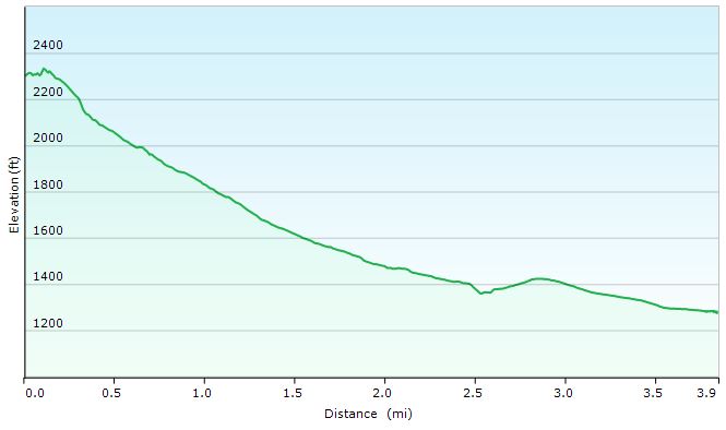
Great Gulf Loop Day 3 Elevation Profile - Sintax77

Great Gulf Loop Day 3 Elevation Profile – Sintax77

Day 3 Mileage: 3.9
Day 3 Gross Elevation Gain: 108′


Mileage Grand Total for Trip: 25.6
Gross Elevation Gain Grand Total for Trip: 10,319′

When Sub-Zero Camping Goes Wrong – Winter Backpacking in the White Mountains


Join us for some frigid winter camping and backpacking along King Ravine in the White Mountains.

For this overnight backpacking trip we’ll be heading up towards Mt Adams, along the Presidential Range in New Hampshire’s White Mountain National Forest in early February.  This trip was done almost a year to the day after our High Winds Hiking trip during the previous season.  Only instead of temperatures in the 20’s to 30’s, we had a dramatically different temperature range the low teens at it’s warmest, down to roughly 20° below zero at night.  Ouch.  Luckily, we didn’t have the extreme winds that we encountered on that last February trip.  One or the other is one thing.  Both together, now that’s what you don’t want.

As you’ll see in the video though, things still didn’t go – how should I say – well, as planned.  Thankfully, we were able to make the best of it and play things by ear.  While I certainly would have like things to have gone a bit closer to our anticipated itinerary, I think it still ended up be a quite memorable trip.  When things go as planned, that’s a vacation.  When things go awry and you have to react and adapt, that’s an adventure.  And that, after all, is what we’re truly after.  As long as know one get hurt, or suffers too much mental trauma, I’ll chalk it up as a win.

Below is a list of trails used, in order, as well parking info and other logistical items.  Unfortunately, due to the sub-zero temps, there was no full gps track recorded for this trip.  After ripping through two sets of Ultimate Lithiums in my Garmin Oregon 650 GPS on day one, I made the call to reserve my remaining rechargeable batteries for emergency route fining only.  On my last winter trip to the Dolly Sods, with temps in the low 20’s, I was able to go the entire 3 day trip on one set of lithium with juice to spare.  My performance was quite different at 15 or so below zero, though.  Once it warms up a bit, we’ll get back to recording full track data as usual.

Parking Location
Appalachia Trailhead
44.371470, -71.289391
(Not too far from the intersection of US Rt 2 and Dolly Copp Rd, in Gorham NH)

Trails Used
Airline Trail to
intersection with Upper Bruin Trail, just above treeline in the Alpine Zone
Planned Campsite:  Valley Way Tentsite or nearby vicinity, via Valley Way Trail
Actual Campsite:  Back below treeline, along the Airline Trail.

Our plan was to summit Mt Adams the following day and return cheerfully to our previous night’s campsite, base camp style.  As seen in the video, things got a bit more complicated, due to extreme snow drifting along King Ravine’s Alpine Zone, heading towards Madison Hut and the intersection with the Appalachian Trail towards Mt. Adams.  The plan was to save Adams for day two and to use Upper Bruin Trail to head back below treeline to establish a base camp, after getting some  brief views in the ravine above treeline.  Despite having been to this area twice before in milder weather, the high snow drifts and unbroken trail made navigation, umm, complicated, to say the least.  Add Mike’s little ordeal to the mix, and you’ve got yourself a very interesting little winter camping trip.  But I’ll let you find out how all that goes in the actual video…

 A Quick Overview of some of the Gear Used
Big Agnes 6p tent (yes, is a car camping tent.) Split three ways.
EMS Longtrail 70 Backpack
MSR Denali Ascent Snowshoes
Kahtoolah MICROspikes (the plan was to feel things out while ascending Mt Adams, and turn back if it felt like crampons were more acceptable)
CAMP Snow Shovel
MSR Rapidfire Stove (Inverted canister stove, no longer produced)
*Mike carried an MSR Whisperlight Universal, rigged for white gas, which we ended up using at night due to the colder temps.
Big Agnes Q-Core SL Sleeping Pad
Hammock Gear Burrow 0 Top Quilt
GSI Halulite Tea Kettle, 32 oz, for snow melting
Vargo 450ml titanium cup
Sea to Summit Alpha Light cutlery set (knife, fork, spoon)

Camera Gear Used
Sony Handycam HDR-cx380, primary cam
GoPro Hero 3, Black edition, secondary cam.
RavPower 10,000 mAH usb battery pack recharger