Winter Hammock Camping in a Snow Storm – Sub Zero Backpacking in the White Mountains

Join me for 3 days of Winter Camping, Hammock setup, Snowshoeing, Camp Stove testing with multiple Fuel types for Snow Melting, Cold Weather Clothing tips & more on this mega episode.

For this solo winter backpacking and snow camping adventure, I’ll be heading into the deep snow of the Sandwich Range Wilderness in New Hampshire’s White Mountains.  If you’re serious about geeking out on the finer details of camping in deep snow in temperatures below zero F, this video is for you.  We’ll be spending a lot of time at camp experimenting, demonstrating and discussing a lot of winter camping topics in detail, including –

  • Snowshoe types and usage
  • Campsite selection
  • Using the Outdoor Vitals Mummy Pod System
  • Snow melting for drinking water
  • Extensive testing using the Optimus Polaris Optifuel stove comparing several camping fuel types for winter cooking & snow melting – LPG canister fuel, white gas, and diesel fuel. Liquid fuel stove priming, inverted canister mode, fuel efficiency, etc.
  • Winter hammock camping tarp setup in the snow.
  • Trekking poles for winter hiking
  • Staying warm on winter camping trips – clothing layer management and strategy, sleeping bag choices, hot water bottle for supplemental warmth.

Trailhead Parking

  • Oliverian Brook Trailhead, Kancamangus Hwy, Albany, NH
  • N43° 59.747′ W71° 21.032′

GPS Data for this trip is available on the Trip Data Page, or by using this link for direct download: Sandwich Range Winter 2018 Hammock Camping Trip GPS Data – Sintax77

Stats & Trails Used, Day One

  • Park at Oliverian Brook Trailhead.
  • Head south on the Oliverian Brook Trail
  • Setup camp in the flat area near the junction with Passaconaway Cutoff Trial

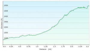
Day 1 Elevation Profile – Sandwich Range Winter – Sintax77

Day 1 Mileage: 2.5 miles
Day 1 Elevation Gain: 502′

Stats & Trails Used, Day Two

  • Continue south on the Oliverian Brook Trail.
  • At the junction, take the Passaconaway Cutoff, towards the summit of Mt Passaconaway.
  • Head back down the same way, to return to base camp.

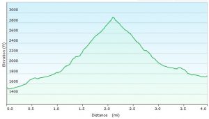
Day 2 Elevation Profile – Sandwich Range Winter – Sintax77

Day 2 Mileage: 4 miles
Day 2 Elevation Gain: 1,473′

Notable Gear Used / Seen on this Backpacking Trip:

Pack
Backpack – EMS Longtrail 70 (2011 model)

Location
GPS Unit – Garmin Oregon 650

Cooking & Eating Utensils
Multi-fuel Camping Stove – Optimus Polaris Optifuel
Cook Pot, 1L – MallowMe
Cup – Vargo 450ml Titanium Cup
Spork, Long – Sea to Summit Alpha

Hammock System
Hammock Body – Dutchware NylonD 11′ Netless
Hammock Suspension – Dutchware Polyester Tree Straps with Titanium Cinch Buckles

Sleep System
Sleeping Bag / Hammock Quilt – Outdoor Vitals Mummy 15° Down Model

Shelter
Tarp – Hammock Gear Cuben Hex Tarp
Ground Cloth – Tyvek, long

Water Storage
Water Bottle – 40 Below 1 Liter Bottle w/ Bottle Boot

Light Sources
Flashlight / Clip-on Headlamp – Olight S1 Mini Baton

First Aid & SOS Messenger
Spot Messenger

Traction & Traversal
MSR Denali Ascent Snowshoes *No longer in production, I got them on Ebay. A modern equivalent would be something like the MSR Evo Ascent Snowshoe.
Kahtoola Micro Spikes *I didn’t end up using them, as I had my snowshoes on most of the time, but I always throw these in the pack for snow trips to deal with icy terrain.
Trekking Poles – CNOC Outdoors Carbon Fiber Vertex Trekking Poles

Snow Camping Tools
Camp Brand Snow Shovel *I’m not sure my model is in production anymore.  The closest current version seems to be the Camp Rocket Shovel.

Clothing
Mid Layer – Surplus Military Fleece
US Army Gen III Extreme Cold Weather Trousers
Gloves – Sealskinz Water Proof Ultra Grip Gloves
EMS Over-mittens w/ US Army Wool Gloves
Boots, Winter High Top Garmont GTX
Face mask / neck gaiter by Seirus Innovation

That Time I Hiked with a Broken Face – Backpacking the Great Gulf Wilderness

Join TJ & I for 3 days of hiking, camping & backpacking in New Hampshire’s Great Gulf Wilderness.  Oh, & I also fall on my face.  

For this adventure, we’ll be revisiting an attempt at a hike that I originally did as a solo backpacking trip a few years back.  A rather aggressive loop, chalking up 30+ miles and over 15,000 feet gross elevation gain, the plan was to give it another go while giving TJ an ultimate sampler platter of the White Mountains.  As fate would have it, things would corkscrew towards another outcome…

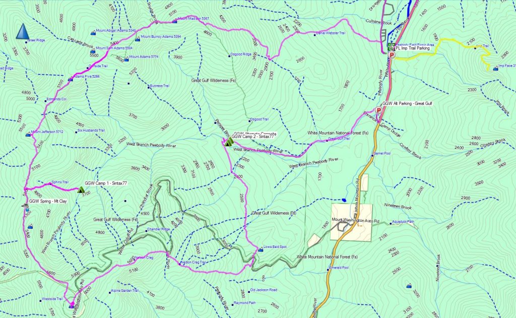
Great Gulf Loop Route Overview - Sintax77

Great Gulf Loop Route Overview – Sintax77

Trailhead Used: Imp Trailhead on Rt 16 – N44° 19.408′ W71° 13.016′

Full GPS track data and waypoints for various POI’s on this trip are available for download on the Trip Data Page.

Trails Used, Day 1 (in order)
Road hike north on Rt 16 to Dolly Copp Campground
Daniel Webster Scout Trail
Appalachian Trail South
Sphinx Trail
Camp along Sphinx Trail, just before junction with Great Gulf Trail

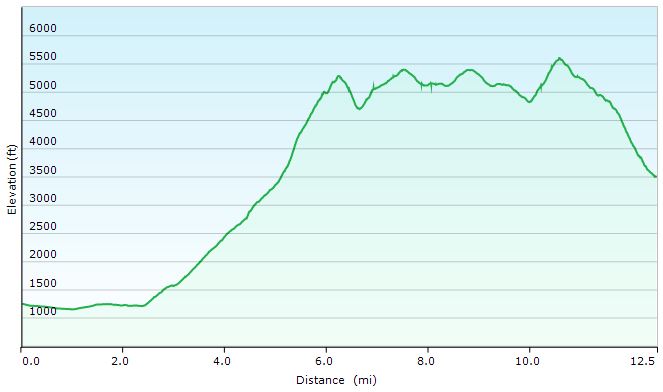
Great Gulf Loop Day 1 Elevation Profile - Sintax77

Great Gulf Loop Day 1 Elevation Profile – Sintax77

Day 1 Mileage: 12.5 miles
Day 1 Gross Elevation Gain: 6,661′

Trails Used, Day 2 (in order)
Double back on Sphinx Trail
Appalachian Trail South
Trinity Heights Connector to Summit of Mt Washington
Have a Chili Dog at the Summit
Nelson Crag Trail
Appalachian Trail South
Great Gulf Trail
Camp near Gulf Trail along ridge

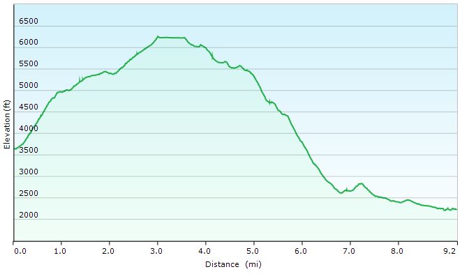
Great Gulf Loop Day 2 Elevation Profile - Sintax77

Great Gulf Loop Day 2 Elevation Profile – Sintax77

Day 2 Mileage: 9.2 miles
Day 2 Gross Elevation Gain: 3,658′

Trails Used, Day 3 (in order)
Great Gulf Trail
Short road hike back to car parked at Imp Trail Head

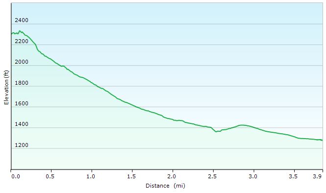
Great Gulf Loop Day 3 Elevation Profile - Sintax77

Great Gulf Loop Day 3 Elevation Profile – Sintax77

Day 3 Mileage: 3.9
Day 3 Gross Elevation Gain: 108′


Mileage Grand Total for Trip: 25.6
Gross Elevation Gain Grand Total for Trip: 10,319′

Hiking the Whites – Zeke’s First Backpacking Trip

Join Mike, TJ and I for 4 days of hiking & camping as we initiate our friend Zeke on his very first backpacking trip!

For this backpacking trip, we’ll be visiting one of my favorite areas, the White Mountains, for a counterclockwise Pemi Loop.  While I’ve previously done this loop as a solo hike, I switched things up this time by doing the loop in the opposite direction, starting with Bondcliff Trail and the Bonds and ending with a traverse of Franconia Ridge to return to the Lincoln Woods Visitor Center where we started. We also stretched the hike out to 4 days and 3 nights.  This enabled us to get some more camping and exploring in, and also let us do less miles per day, since this was our friend’s first backpacking experience.  The White Mountains are home to some of the most aggressive hiking trails in the country, and our goal was to make sure he actually wanted to do this again!

If you’ve never done a Pemi Loop before and are looking for some more logistics, trail listings, etc, feel free to check out my previous solo video.  For this video, we’ll be focusing more the amazing views, camp camaraderie and of course, the biggest question – will Zeke ever want to do this again?  Or will he want to push us off one of the numerous precipices that the Pemigewasset Wilderness has to offer…

 For info on the “helicopter situation” click here for a link to an August 28th post the Pemigewasset Valley Search and Rescue Team’s Facebook page.

 A note on GPS Data: I didn’t record new GPS track data for this trip, as the data from my previous trip pretty much covers the route (in reverse of course) and includes waypoints for points of interest included in that video as well as this one.  I also tagged a decent amount of extra potential tent and hammock camping spots as I hiked, which some may find useful if looking for alternative camping spots.

Notable Items and Gear that may be of interest:

My hammock – Dream Hammock Darien, single layer.
Mike’s Hammock – Dream Hammock Thunderbird, double layer
TJ’s hammock – Dutchware NylonD hammock, 11 foot, single layer with Dutchware Summer Sock

Zeke’s Tent – Marmot Eos 1P Tent

Myself and Mike’s tarps – Both are Hammock Gear Cuben Hex Tarps with 11 foot ridge lines.

TJ’s Tarp – Hennessy Deluxe Tarp, 70D model, 12’x10′

 My underquilt – Hammock Gear Phoenix 30°
TJ’s underquilt – Hammock Gear Incubator 40° (seen up close in my earlier post here)

Mike’s underquilt – HG Phoenix 20°

Top Quilts – Hammock Gear Burrow 40° for me and HG Burrow 20° for Mike (TJ used a “regular” down sleeping bag as a quilt.)
My backpack – Osprey Hornet 46 (no longer in production)
Mikes backpack – Osprey Exos 58
Zeke’s backpack – Gregory Contour 70

Dehydrated meals tried in the video:  Mountain House, Packit Gourmet, and Alpine Aire.

When Sub-Zero Camping Goes Wrong – Winter Backpacking in the White Mountains


Join us for some frigid winter camping and backpacking along King Ravine in the White Mountains.

For this overnight backpacking trip we’ll be heading up towards Mt Adams, along the Presidential Range in New Hampshire’s White Mountain National Forest in early February.  This trip was done almost a year to the day after our High Winds Hiking trip during the previous season.  Only instead of temperatures in the 20’s to 30’s, we had a dramatically different temperature range the low teens at it’s warmest, down to roughly 20° below zero at night.  Ouch.  Luckily, we didn’t have the extreme winds that we encountered on that last February trip.  One or the other is one thing.  Both together, now that’s what you don’t want.

As you’ll see in the video though, things still didn’t go – how should I say – well, as planned.  Thankfully, we were able to make the best of it and play things by ear.  While I certainly would have like things to have gone a bit closer to our anticipated itinerary, I think it still ended up be a quite memorable trip.  When things go as planned, that’s a vacation.  When things go awry and you have to react and adapt, that’s an adventure.  And that, after all, is what we’re truly after.  As long as know one get hurt, or suffers too much mental trauma, I’ll chalk it up as a win.

Below is a list of trails used, in order, as well parking info and other logistical items.  Unfortunately, due to the sub-zero temps, there was no full gps track recorded for this trip.  After ripping through two sets of Ultimate Lithiums in my Garmin Oregon 650 GPS on day one, I made the call to reserve my remaining rechargeable batteries for emergency route fining only.  On my last winter trip to the Dolly Sods, with temps in the low 20’s, I was able to go the entire 3 day trip on one set of lithium with juice to spare.  My performance was quite different at 15 or so below zero, though.  Once it warms up a bit, we’ll get back to recording full track data as usual.

Parking Location
Appalachia Trailhead
44.371470, -71.289391
(Not too far from the intersection of US Rt 2 and Dolly Copp Rd, in Gorham NH)

Trails Used
Airline Trail to
intersection with Upper Bruin Trail, just above treeline in the Alpine Zone
Planned Campsite:  Valley Way Tentsite or nearby vicinity, via Valley Way Trail
Actual Campsite:  Back below treeline, along the Airline Trail.

Our plan was to summit Mt Adams the following day and return cheerfully to our previous night’s campsite, base camp style.  As seen in the video, things got a bit more complicated, due to extreme snow drifting along King Ravine’s Alpine Zone, heading towards Madison Hut and the intersection with the Appalachian Trail towards Mt. Adams.  The plan was to save Adams for day two and to use Upper Bruin Trail to head back below treeline to establish a base camp, after getting some  brief views in the ravine above treeline.  Despite having been to this area twice before in milder weather, the high snow drifts and unbroken trail made navigation, umm, complicated, to say the least.  Add Mike’s little ordeal to the mix, and you’ve got yourself a very interesting little winter camping trip.  But I’ll let you find out how all that goes in the actual video…

 A Quick Overview of some of the Gear Used
Big Agnes 6p tent (yes, is a car camping tent.) Split three ways.
EMS Longtrail 70 Backpack
MSR Denali Ascent Snowshoes
Kahtoolah MICROspikes (the plan was to feel things out while ascending Mt Adams, and turn back if it felt like crampons were more acceptable)
CAMP Snow Shovel
MSR Rapidfire Stove (Inverted canister stove, no longer produced)
*Mike carried an MSR Whisperlight Universal, rigged for white gas, which we ended up using at night due to the colder temps.
Big Agnes Q-Core SL Sleeping Pad
Hammock Gear Burrow 0 Top Quilt
GSI Halulite Tea Kettle, 32 oz, for snow melting
Vargo 450ml titanium cup
Sea to Summit Alpha Light cutlery set (knife, fork, spoon)

Camera Gear Used
Sony Handycam HDR-cx380, primary cam
GoPro Hero 3, Black edition, secondary cam.
RavPower 10,000 mAH usb battery pack recharger

Solo Hiking the White Mountains – Backpacking the Presicat Loop

Join me for 3 days of hiking, backpacking, and stealth camping in the White Mountains.

For this late Summer trip (August), I’ll be going for the full range of White Mountains backpacking and hiking experiences. From the seclusion of rugged wilderness areas, to the tourist laded summit of Mount Washington. Encompassing both the western and eastern sides of Rt 16, the goal is to complete a 3 day loop comprised of the Presidential Range, Tuckerman Ravine, Wildcat Range, and the Carter-Moriah Range before returning to the car.

If you’re interested in the gear, you can check out my full Ultralight Backpacking Gear List Video

The 11lb base weight system seen in that video is identical to my system for this trip with the exception of the following changes which increased the base weight by about 2.5 lbs:

Fleece Sleeping bag (21oz) replaced with Suisse Sport 30 degree mummy bag. (3lbs)
Mont-bell Ultralight Down Parka (9oz) was brought for additional warmth.

I carried around 7lbs food and water (usually only 1 liter), so total pack weight was still around 20 lbs or so.

GPS Tracking Data for Entire Trip is Available for download on the Trip Data page.
**Tracks for each day end on the trail prior to picking a specific campsite. Recording is resumed on the beginning of each day, back on the trail from night before.

Parking: Imp Trail head 44°19’23.40″N 71°13’0.99″W
(**not starting on Imp trail, this will be the finish)

Trails Used (in order):

Day 1
Road Hike to Dolly Copp Campground
Begin on Daniel Webster-Scout Trail
Osgood Trail
Gulfside Trail (passing Madison Spring Hut on descent)
Mt Jefferson Loop Trail
Return to Gulfside Trail
Sphinx Trail
Stealth Camp towards bottom of Sphinx Trail in the Great Gulf Wilderness
Daily Totals: 11.40 Miles, 6,008 feet elevation gain

Day2
Back up Sphinx Trail
Gulfside Trail
Trinity Heights Connector (to Mt Washington Summit)
Tuckerman Ravine Trail
Lions Head Trail
Alpine Garden Trail
Tuckerman Ravine Trail
Grab a drink at Pinkham Notch Visitor Center and cross Rt 16 to
Lost Pond Trail
Wildcat Ridge Trail
Stealth Camp before getting to Carter Notch Hut
Daily Totals: 13.80 Miles , 6,755 feet elevation gain

Day 3
Carter-Moriah Trail
Carter Dome Trail
Nineteen Mile Brook Trail
Totals: 8.77 miles, 2,471 feet elevation gain

Trip Grand Totals: 34 Miles, 15,234 feet elevation gain.


Summit’s for this Trip in order:
Mt Madison, Mt Jefferson, Mt Washington, Wildcat D, Wildcat C, Wildcat B, Wildcat Mountain, Carter Dome, Mt Hight

Camera Used: Samsung H-300