Solo Hiking the White Mountains – Backpacking the Presicat Loop

Join me for 3 days of hiking, backpacking, and stealth camping in the White Mountains.

For this late Summer trip (August), I’ll be going for the full range of White Mountains backpacking and hiking experiences. From the seclusion of rugged wilderness areas, to the tourist laded summit of Mount Washington. Encompassing both the western and eastern sides of Rt 16, the goal is to complete a 3 day loop comprised of the Presidential Range, Tuckerman Ravine, Wildcat Range, and the Carter-Moriah Range before returning to the car.

If you’re interested in the gear, you can check out my full Ultralight Backpacking Gear List Video

The 11lb base weight system seen in that video is identical to my system for this trip with the exception of the following changes which increased the base weight by about 2.5 lbs:

Fleece Sleeping bag (21oz) replaced with Suisse Sport 30 degree mummy bag. (3lbs)
Mont-bell Ultralight Down Parka (9oz) was brought for additional warmth.

I carried around 7lbs food and water (usually only 1 liter), so total pack weight was still around 20 lbs or so.

GPS Tracking Data for Entire Trip is Available for download on the Trip Data page.
**Tracks for each day end on the trail prior to picking a specific campsite. Recording is resumed on the beginning of each day, back on the trail from night before.

Parking: Imp Trail head 44°19’23.40″N 71°13’0.99″W
(**not starting on Imp trail, this will be the finish)

Trails Used (in order):

Day 1
Road Hike to Dolly Copp Campground
Begin on Daniel Webster-Scout Trail
Osgood Trail
Gulfside Trail (passing Madison Spring Hut on descent)
Mt Jefferson Loop Trail
Return to Gulfside Trail
Sphinx Trail
Stealth Camp towards bottom of Sphinx Trail in the Great Gulf Wilderness
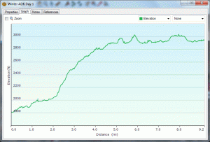
Daily Totals: 11.40 Miles, 6,008 feet elevation gain

Day2
Back up Sphinx Trail
Gulfside Trail
Trinity Heights Connector (to Mt Washington Summit)
Tuckerman Ravine Trail
Lions Head Trail
Alpine Garden Trail
Tuckerman Ravine Trail
Grab a drink at Pinkham Notch Visitor Center and cross Rt 16 to
Lost Pond Trail
Wildcat Ridge Trail
Stealth Camp before getting to Carter Notch Hut
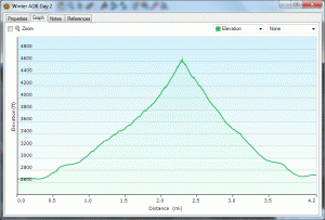
Daily Totals: 13.80 Miles , 6,755 feet elevation gain

Day 3
Carter-Moriah Trail
Carter Dome Trail
Nineteen Mile Brook Trail
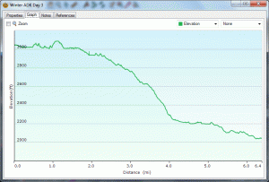
Totals: 8.77 miles, 2,471 feet elevation gain

Trip Grand Totals: 34 Miles, 15,234 feet elevation gain.


Summit’s for this Trip in order:
Mt Madison, Mt Jefferson, Mt Washington, Wildcat D, Wildcat C, Wildcat B, Wildcat Mountain, Carter Dome, Mt Hight

Camera Used: Samsung H-300

Hammock Camping the Catskill Mountains – New York Backpacking in Summer

Exploring New York’s Catskill Mountains and setting up my Hennessy Hammock for it’s first test in the wild. Hennessy model is the “Expedition A-Sym”. A detailed gear list is at the bottom of this description.

This was two day, one night, “out and back” hike, covering a total distance of 24 miles in the Slide Mountain Wilderness Area. The individual trails hiked on this trip are actually a part of the New York Long Path, a 347 mile trail beginning at the George Washington Bridge in Fort Lee, New Jersey and ending in Altamont, New York, in the Albany area.

We’ll be visiting 3 peaks on this over-nighter: Peekamoose Mt, Table Mt, and Slide Mt. (Slide mountain is the Catskill’s highest peak, at an elevation of 4,180 feet.)

Parking Location and Trailhead Coodinates: 41.915164, -74.429080
**Parking is Free and there is plenty of room for cars. No permit is required for backcountry camping, unless you’re out for more than 3 days. No camping or fires are permitted above 3500 feet, except between December 21 and March 21.

Starting Trailhead: Peekamoose-Table Trail on Peekamoose Rd (Rt42), heading towards Slide Mountain.

Trails Taken In order:
Peekamoose-Table Trail
Phoenicia-East Branch Trail
Curtis-Ormsbee Trail
Wittenberg-Cornell-Slide Trail
(Note: These individual trails also coincide with NY Long Path)

Total Mileage for Day One: 8
Total Mileage for Day Two: 16
Trip Total: 24 Miles

Gear List for system seen in this video:

***Base Items**

EMS Long Trail 70 Backpack (top pouch removed)
Sea to Summit Pack Cover
Hennessy Hammock Expedition A-Sym (lighter versions available if your willing to spend the $$ and give up some support)
Klymit Inertia X-Frame Ultralight Sleeping Pad
Sea to Summit Toaster – Fleece Sleeping Bag Liner (used as primary bag)
1 ReVive Solar ReStore usb charger
Osprey 2 liter Nalgene Bladder for hydration
Sawyer Squeeze Water Filtration System
1 Liter Disposable Plastic Water Bottle (plus 2 spare 16oz bottles)
Paper map print-outs from Topo 9 software (lighter than a full size map)
Brunton Classic Compass
Sunscreen (travel size tube)
1 oz bottle of Ben’s Max 100 98% DEET insect repellent
‘Light My Fire’ Spork
Homemade Ultralight Cookset – video: http://youtu.be/gvpD1hEztvY
Sea To Summit ‘Insect Shield’ Mosquito Head Neat
EMS ‘Velocity’ synthetic lightweight long sleeve shirt
Spare synthetic tee shirt and lightweight shorts.
Spare EMS synthetic socks
Princeton Tec Byte Headlamp
Toiletries (TP, small mirror, travel toothbrush and paste, spare contacts)
Superglue, assorted band-aides and extra zip-lock bags for trash etc
Large lightweight trash bag – used as ground cover to organize gear, etc

** Items Worn (I did not count these towards base weight) **
EMS Camp Cap (synthetic fast dry, & lightweight!)
EMS Convertible Camp Pants / Shorts
Garmont Zenith Mid GTX Hiking Boots
EMS synthetic socks
4Sevens Preon 2 Flashlight
Leatherman Squirt Ultra-Light Multi-Tool
SOG Blink Spring Assisted Knife

** Consumables for trip (not counted towards base weight)**
2 Pounds Food
5 Pounds initial water supply (2.5 liters)
3 oz of Denatured Alcohol (fuel for DIY ultralight stove)

Base Weight: 16 pounds
Total weight w/ consumables for Catskills overnighter: 23 pounds