A review of the Darien Ultralight hammock, by Dream Hammock.
Model: Darien Length: 10ft Width: 60 inches Layers: Single Layer Outside Fabric & Color: 1.0 ACU Camo Suspension: Cinch Buckle Asym Lay: Right
Total Weight (including suspension and stuff sack): 17.5 ounces
Also available with whoopie sling suspension, double or single layer, and various color and weight fabrics, DWR, non-DWR, calendared finish, pure finish, rip-stop, taffeta, nylon, polyester, you name it. Just go check out the fabric page at www.dream-hammock.com already! 🙂
Link to my order stats and photo on Dream Hammock website: http://www.dream-hammock.com/order_detail.html?order=1157
I’ve been getting some questions regarding the appearance of a new hammock suspension system in my most recent solo backpacking video. In this video we’ll take a look at why I switched to Dutch Cinch Buckles from Kammok Python Straps as my primary hammock suspension system.
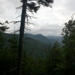
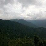
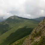
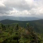
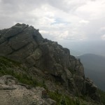
Come along for 3 Days of Hammock Camping, Hiking, and Backpacking on a classic Pemi Loop in New Hampshire’s White Mountains.
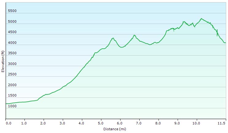
The Pemi Loop, made popular by it’s distinction as one of “America’s Hardest Day Hikes” in a May, 2005 Backpacker Magaizine article, is not actually an “official” trail, but rather a series of AMC (Appalachian Mountain Club) trails joined to create a 31.5 mile tear drop shaped loop in New Hampshire’s Franconia Wilderness Area. GPS track data is available on the Trip Data page.
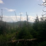
For this hike, I’ll be solo hammock camping with my Hennessy Hammock and the larger 12′ x 10′ Deluxe Hex Tarp, due to the threat of cold and wet late summer weather. In the White Mountains, weather can turn on a dime even with the brightest of forecasts, so when the weather report actually says things are going to be iffy, you’d better take it seriously. For this trip we’ll experience a wide range of conditions – from hazy summer heat, to gusty bursts of hail and chilling nighttime lows.
A video review of the Hammock Gear Burrow 40 Top Quilt.
Specs for the HG Burrow 40 Down Top Quilt (Standard Model) Length: 74″ Width: 50″ Fill Weight: 7.0 oz Total Weight: 11.6 oz
**Total weight for Model Shown in the video: 13.7oz + .40 oz stuff sack, due to upgrading outer fabric to the slightly heavier Argon 90.
Outer Fabric: Argon 90 Woodland Camo (.90 oz per sq yard) Inner Fabric: Argon 67 Black (.67 oz per sq yard) Fill Weight: 7oz ( Quilt uses a Baffled construction for optimal warmth. Overstuffed by request. )
Other Temp Ratings available in the Burrow series:
HG Burrow 50 (sewn through construction)
HG Burrow 0 (Baffled constrution)
HG Burrow 20 (Baffled constrution)
All models available with down overstuff as desired.
Join us for 4 days of hammock camping, hiking and backpacking in North Carolina’s Linville Gorge wilderness area.
Located in the Pisgah National Forest, Linville Gorge – or simply “The Gorge” as local hikers prefer to call it – is a 12 mile long gorge carved into the surrounding southern Appalachian mountains by the Linville River. The distance from upper ridge to the river below is roughly 1,400′, which coupled with the network of minimally maintained wilderness trails and unofficial trails, can make for quite a rugged experience. This is not the rolling mountain experience offered up by the neighboring Smoky Mountains, lumbering just 75 miles to the west. The Gorge has a reputation for being a bit of a beast. And yet for some reason I couldn’t help but notice a permanent trace of laziness in the air.
Typically, I quite enjoy the hustle of a good long distance hike. The more miles, the more exciting the trip, but Linville Gorge quickly had a different affect on me. I spent most of my time on the trail daydreaming about the next time I could be swinging in my hammock. Which was perfect because Mike and I had 4 days off and nothing to do but just that.
Speaking of days off, it should be pointed out that the Forest Service has enacted a consecutive stay limit of 2 days, 3 nights for camping within the Linville Gorge wilderness area. Fortunately, the surrounding Pisgah National Forest does not have such restrictions. With a little planning, you can easily spend a night just outside the limits of the wilderness area and you’re good to go. There are decent opportunities for this strategy along the western side of the Gorge, where the Mountains to Sea Trail follows along the boundary line. From May 1st through October 31st there is also a permit required for back-country camping on weekends and holidays. Thankfully, it’s free and simple – I called a few weeks beforehand and they actually faxed me our pass within a half hour or so.
If you decide to plan a trip of your own, I highly recommend heading over to the forums on Linvillegorge.net. The Gorge Rats have a wealth of knowledge and are very friendly and helpful to those of us noobs looking to rummage through The Gorge. There’s also treasure trove of goodies for your GPS including potential camp sites, water sources, official and unofficial trails, points of interest, etc.
Full GPS data for this trip, recorded with my Garmin Oregon 650, is available for download on the Trip Data page.
Parking Location:
Conley Cove Trail Head N35 53.414 W81 54.380
Link to Nebo Water Gauge: http://waterdata.usgs.gov/usa/nwis/uv?02138500
There are currently no bridges across the river, so trust me, you want to keep an eye on this. Readings of 100 cfs or less seem to be ideal. 200 cfs will create approximately waist deep conditions.
List of Trails Used, Day 1:
Conley Cove Trail
Linville Gorge Trail (Follows river along bottom of gorge)
Set up camp near the banks of the Linville River Mileage for the Day: 10.9 miles
Elevation Gain: 1,627′
Elevation Loss: 2,185′
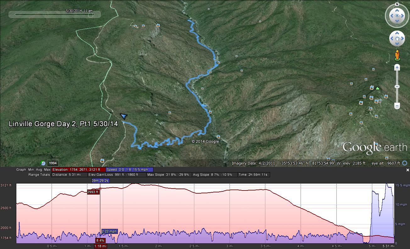
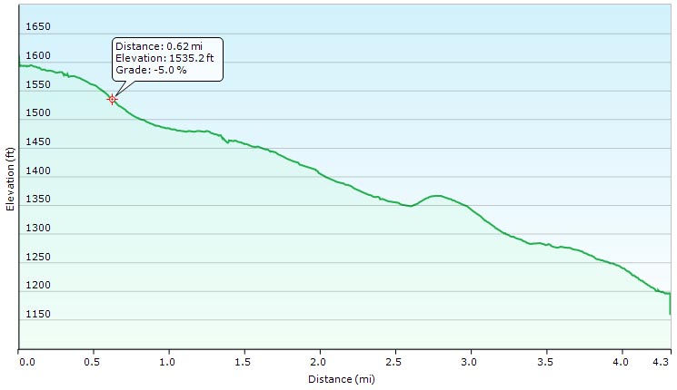
List of Trails Used, Day 2, Part 1: Return to Car via Conley Cove and LGT
Drive to second location. Mileage for the Day Part 1: 3.9 miles
Elevation Gain: 1,204′
Elevation Loss: 535′
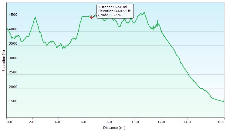
Route for First Day and Second Morning
Second Parking Location:
Wolfpit Trailhead N 35 49.449 W 81 53.365
List of Trails Used, Day 2, Part 2:
Wolfpit Trail
Mountain to Sea Trail (MST)
Set up Camp along cliff near Shortoff Mountain Mileage for the Day Part 2: 2.3 miles Elevation Gain: 1,109′
Elevation Loss: 75′
List of Trails Used, Day 3: Continue on Mountain to Sea Trail (MST)
Set up camp along the MST, outside of wilderness area. Mileage for the Day: 6.3 miles Elevation Gain: 840′
Elevation Loss: 1,112′
List of Trails Used, Day 4:
Reverse course on the Mountain to Sea Trail (MST)
Shortcut via Jeep Trail (circumvents Day 2 Campsite)
Wolfpit Trail
Return to Wolfpit Parking area and car Mileage for the Day: 5.8 miles Elevation Gain: 892′
Elevation Loss: 1,795′
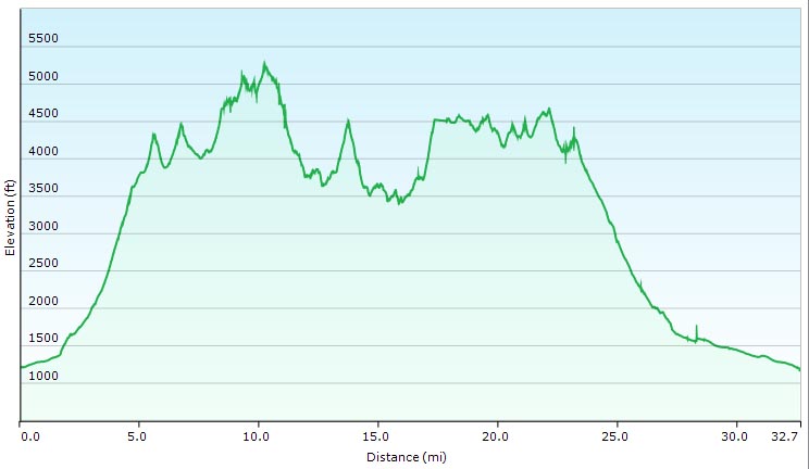
Total Mileage for Trip: 29.2 miles Total Elevation Gain for Trip: 5,672′ Total Elevation Loss for Trip: 5,702′
Route for Days 2 – 4
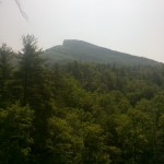
Looking up towards Hawksbill Mountain from the Linville River.
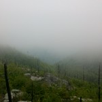
Looking down upon the Linville River, just north of the former Spence Bridge.
Unboxing my new hammock underquilt, the Hammock Gear Incubator 40 Under Quilt.
This is just a quick look the latest addition to my hammock camping gear list. I plan to take this down under quilt on my next multi-day backpacking trip video, so look for more to follow!

 , due to the threat of cold and wet late summer weather. In the White Mountains, weather can turn on a dime even with the brightest of forecasts, so when the weather report actually says things are going to be iffy, you’d better take it seriously. For this trip we’ll experience a wide range of conditions – from hazy summer heat, to gusty bursts of hail and chilling nighttime lows.
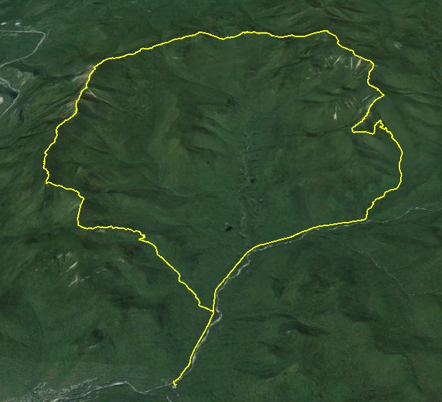

 equipped with
 for Carrying Camera Gear
 ,
,  ,
, 
 , is available for download on the
  with standard tarp
 with
with Carabiners
 (12’x12′)
 for tarp pullouts
 with Black Diamond Neutrino Carabiners