My Friend Says He Hates Hiking …So We Went Backpacking

3 Days of Hiking, Backpacking, and Camping in Northern Utah’s Stansbury Mountain Range.

For the adventure, Kyle and I decided to do a fall backpacking loop just outside of Salt Lake City, with the 11,000 foot Deseret Peak as our main focal point.

Located about 20 miles west of Salt Lake City, the Stansbury Mountains are a 28-mile long range with an average elevation of around 8,000 feet or so.   It is named for U.S. Army Major Howard Stansbury, a topographical engineer, who led an expedition that surveyed the region back in the 1860’s.

For sleep and shelter I packed in my trusty trekking pole tent, a three-season inflatable sleeping pad, and a 30 degree sleeping bag for the expected lows going down to just above freezing or so.  Kyle went with similar setup, swapping the 20 degree sleeping bag for a warmer 15 degree quilt, and a lighter trekking pole tent made of Dyneema fiber.

Standing at 11,022 feet, Deseret Peak the tallest peak on the Stansbury Range, and offers stunning 360 degree views of the surrounding Great Salt Lake and the Bonneville Salt Flats.  There’s also a nearby Air Force Base, as well some U.S. Army proving grounds nearby.  The latter made for some interesting sights on day two, to say the least…

Check out Kyle’s Channels on YouTube

Kyle Hates Hiking – for Spooky Scary Outdoor Stories
Trail Tales Podcast – For fun and in depth backpacking talk

Trailhead Used
Stansbury Front Trail – OP Miller Campground
Forest Rd 001, Dugway, UT 84022
40.52799098486984, -112.5918796076991

Continue reading

50 Miles of Hammock Camping in 3 Days – Backpacking on Cranberry Lake

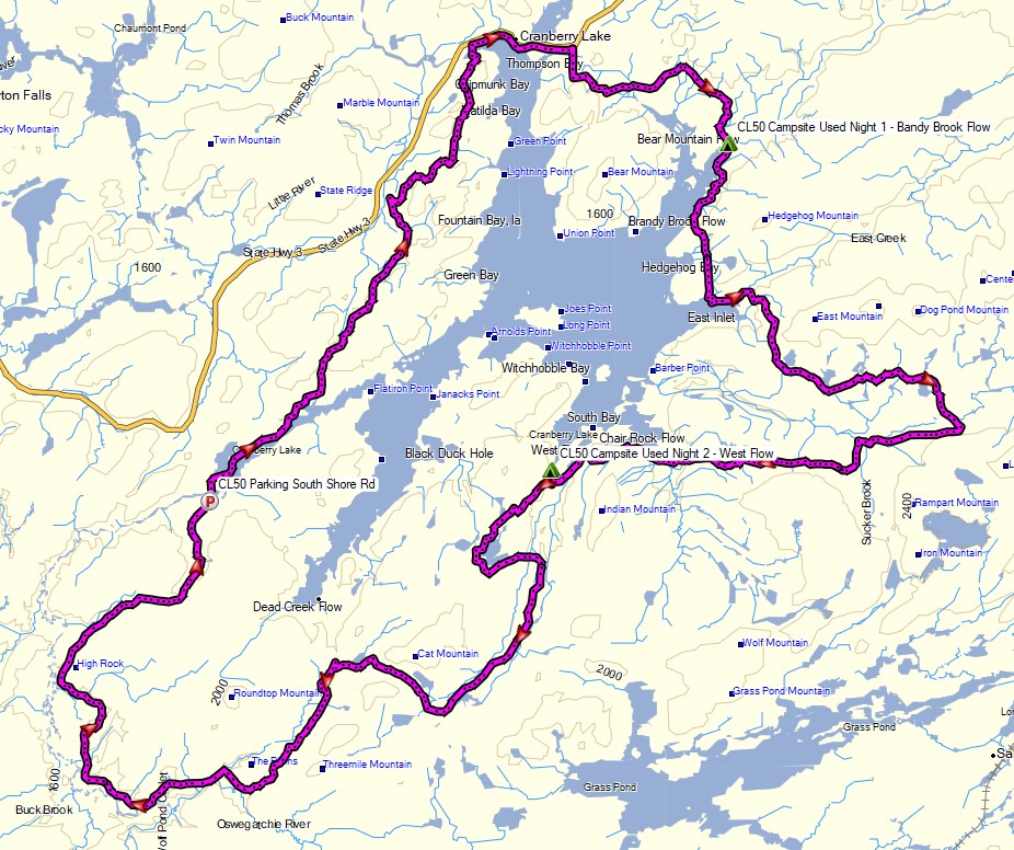
3 days of Backpacking & Hammock Camping along Cranberry Lake in the Adirondacks

FTC Disclosure: This post contains affiliate links, which means I may receive a commission for purchases made through some of my links.

For this adventure, I decided to do a fall backpacking trip with some higher trail mileage than I’ve been doing lately. Nestled in New York’s Five Pond Wilderness, the Cranberry Lake 50 is a fifty mile loop hike that circumnavigates it’s namesake, and passes by many smaller ponds along the way as well. Most of these smaller ponds have campsites or even a lean-to shelter nearby, which is quite nice.

The CL50 is not really an individual trail, but a collection of trail sections from 12 other trails is the area.  The route is well blazed with blue CL50 plastic discs nailed to trees along the way.  The trails used to make up the CL50 are blazed with similar yellow trail discs, so you will often see both blazes simultaneously.

The Cranberry Lake 50 goes directly through two towns – Wanakena, where I started, and the town of Cranberry Lake.  There’s only about 10 trail miles between them, so neither really poses much logistical value for resupplying, but they are nice towns to stroll through.

I chose to do the loop counter clockwise from Wanakena because the last 10 miles traverse some muddy wet sections due to beaver dams, so I figured it would be best to save that for the last afternoon.

I typically like to hike my backpacking trips on a 3 day, 2 night timeline, so that meant my daily trail mileage had to be around 17 miles or so during the shortened daylight hours of October.  On the upside, this hike is primarily along the perimeter of a lake, with minimal elevation changes, but did I mention that I hadn’t done a high mileage trip in a while? Yeah, the headlamp got a good amount of usage on this one. Let the night hiking begin…

Route Overview – Cranberry Lake 50 Backpacking Loop – Sintax77

Continue reading