Winter Camping and Finding a Plane Crash – Mt Success DC-3

Backpacking & Solo Winter Camping in search of a 1954 commercial airline crash near the summit of Mt Success in the White Mountains.

FTC Disclosure: This post contains affiliate links, which means I may receive a commission for purchases made through some of my links.

For this 3 day, 2 night camping trip, I headed up to a lesser traveled corner of New Hampshire’s White Mountain National Forest for some snowshoeing, camp cooking, and bit of New England aviation history.

My goal for this adventure was to find the resting place of Northeast Airlines Flight 792, which crashed on approach to Berlin Municipal Airport during inclement weather on November 30th, 1954. It made contact in the dense trees near the summit of Mt Success at an elevation of 3,390 feet.  More information on the details of Flight 792 and the circumstances of it’s survivors can be found in this copy of the official Accident Investigation Report

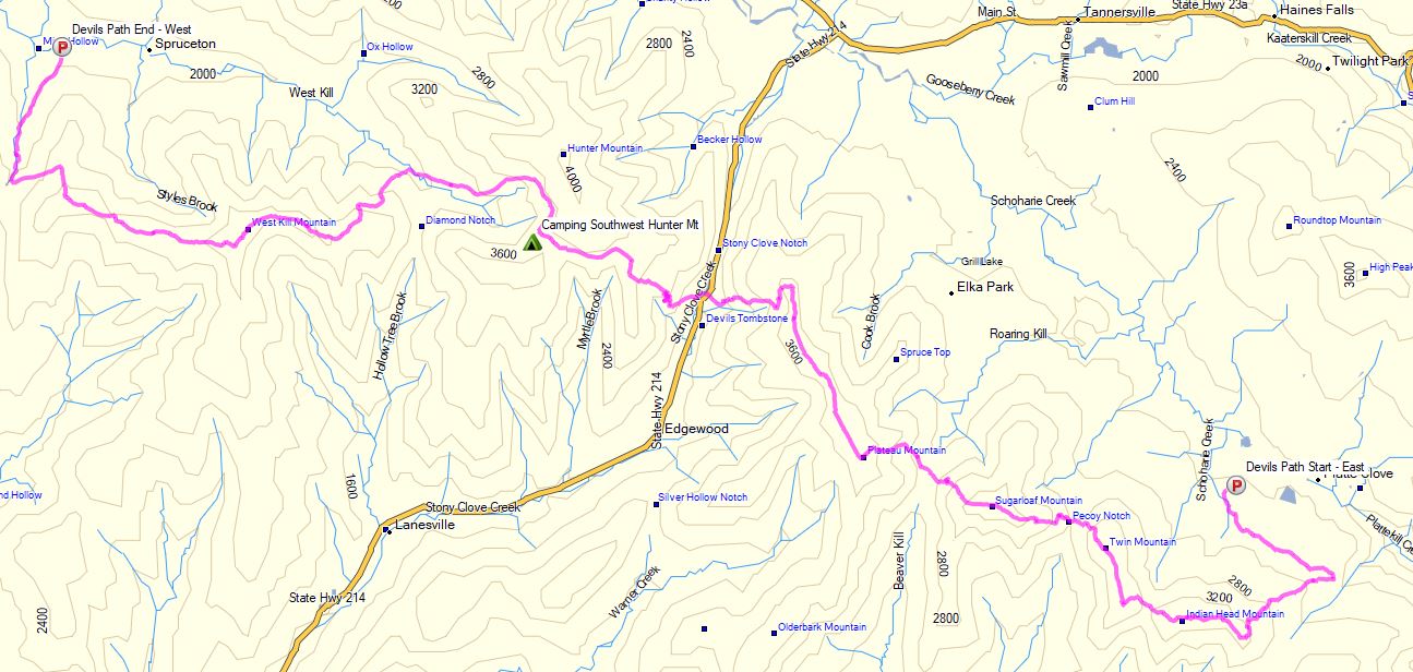
The 6.5 mile hike to get there would require a gross elevation gain of roughly 3,700 feet on potentially unbroken trail in deep snow.  The final portion of the hike would be an unofficial bushwhack through dense trees and snow.  For this reason, I chose to break up the approach up by setting up camp at roughly the halfway point along Gentian Pond and the nearby lean-to shelter with sweeping views of the Carter-Moriah mountain range.  After camping for the night, I would head up to the top of Mt Success, the first peak of the Mahoosuc Range and the Appalachian Trail’s gateway to Maine. After a few miles and a couple thousand feet of ascent with my trusty snowshoes, I would leave the trail behind in search of the DC-3.

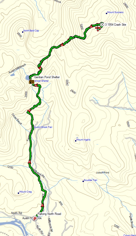
Mt Success DC-3 Winter Backpacking Trip – Route Overview

No permit is required to backcountry camp in the White Mountains, but some locations do require a daily, weekly, or annual pass.  The parking area for this trip did not require a parking fee as of January 2021.

Full GPS track data, including campsites, water sources, etc, for this trip and many others can be downloaded on my Trip Data Page.

Trailhead Used: Austin Brook Trailhead on North Road,  44°24’45.1″N 71°04’05.4″W
North Rd, Shelburne, NH 03581

Continue reading

Stone Shelter Camping in a Snow Storm

Backpacking & Solo Winter Camping during a Snow Storm on the Appalachian Trail and New York Long Path.

FTC Disclosure: This post contains affiliate links, which means I may receive a commission for purchases made through some of my links.

For this 3 day, 2 night camping trip, I decided to do a backpacking loop in New York’s Harriman State park.  Despite being just a half hour north of New York City, Harriman SP offers hundreds of miles of trails, rugged mountain terrain, and rustic lean-to shelters built in the 1920’s.  Covering over 47,000 acres, it stands as the second largest state park in New York and feels more like a national forest shortly after hitting the trail.

Because I did this trip in mid December with a forecast of possible snow and a temp range of just above freezing down to the teens, I figured the crowds would be at a minimum.  The shelters in this area also appeared to have some great personality, so I decided to do something different – go minimal and just sleep in the shelter with a sleeping pad and a down quilt.  This is a convenient and common practice for most Appalachian Trail hikers in fairer weather, but it would be a first for me in winter.

Route Overview – Harriman State Park Winter Backpacking Loop – Sintax77

No permit is required to backcountry camp in Harriman SP, but there are rules and regulations regarding backcountry camping. Most notably, you may only setup camp within 100 yards of one of the park’s lean-to shelters.  You can find more information on the official Harriman State Park website here.

Full GPS track data, including campsites, water sources, etc, for this trip and many others can be downloaded on my Trip Data Page.

Continue reading

Fall Camping in Dolly Sods – Foliage Peaking and Sleeping Pads Leaking

Join Sara and I for 3 Days of Camp Cooking, Hiking, & Backpacking in the Dolly Sods  Wilderness.

For this 3 day, 2 night backpacking trip, Sara, Denali and I decided to do some fall foliage camping in West Virginia’s Dolly Sods Wilderness, part of the larger Monongahela National Forest. Dolly Sods is located in the Allegheny Mountains on the highest plateau east of the Mississippi river and features some of the most varied and scenic terrain available to hikers in the Mid-Atlantic region.

We had our dog with us on this trip, so we decided to give tent camping a go this time around to keep us all together in one spot.  I also decided to totally throw lightweight backpacking out the window for this trip, so I brought along my Fjallraven Kajka 75 backpack and stuffed it to the gills with various backpacking gear, just to have a little fun and switch things up a bit (gear list at end of post).  This decision was made easier by the fact that we were starting at Bear Rocks trailhead, which is already high up on the plateau with minimal elevation changes.

Campsites and great views are fairly abundant in Dolly Sods, so our general plan was to keep the mileage low and focus on a relaxed hiking pace, fun backpacking food and camp cooking.  It was the perfect recipe for a laid back camping trip.  Other than the whole leaking sleeping pad situation to make things more interesting…


Route Overview – Dolly Sods Fall Backpacking Loop – Sintax77

No permit is required to camp in the Dolly Sods Wilderness, but there are rules and regulations regarding backcountry camping. You can find more information on the USFS Dolly Sods website here.

Full GPS track data, including campsites, water sources, etc, for this trip and many others can be downloaded on my Trip Data Page.

Continue reading

Utah RV Camping – Bryce Canyon to Grand Staircase Escalante National Monument

Exploring Southern Utah with an RV from Bryce Canyon National Park to Grand Staircase Escalante National Monument for awesome views, Hiking & Boondocking adventures.

We kept our itinerary pretty loose for this trip, but our general plan was to head from Las Vegas, where we rented our motorhome, towards Bryce Canyon and Escalante in Utah.  We ended up having no problem at all finding boondocking (free) options for all but our last day of RV camping.

Filming Date – Fall, Early October 2020

Day 0 (night before video starts)

  • Fly into Las Vegas Airport
  • Pick up the RV rental at the airport Walmart (we used RVshare.com)
  • Head west 2 hours to St George, Utah.
  • Do a quick boondock camp outside of town in the desert.

Day 1

Continue reading

Solo Backpacking the Virginia Triple Crown – Appalachian Trail Section Hike

3 Days of Backpacking, Hiking & Hammock Camping on the Appalachian Trail in Virginia.

For this late summer backpacking trip I’ll be hiking the Virginia Triple Crown, which consists of three iconic Virginia hiking destinations – McAfee Knob, Tinker Cliffs, and Dragon’s Tooth.

To create the loop, I essentially took an Appalachian Trail section hike and combined it with the North Mountain trail to close it off into a 35 mile backpacking loop. This gave me a healthy southern mix of mountain hiking, open pastures, and sweeping summit views.

I went with my most basic warm weather ultralight backpacking gear list for this trip, just to keep things simple and light. Due to the threat of rain, I also included a full set of rain gear. Surprisingly how I was still able to keep my base weight down to around 7.5 lbs. This was mostly achieved by simply leaving non critical items at home. Notable items are below or you can see my full gear list with weights & gear links on LighterPack here.


Virginia Triple Crown Route Overview – Sintax77

No permit is required to camp in this area, but there are some camping restrictions along the Appalachian Trail portion of the hike as well as some private land traversals.  You can find more information on the Roanoke Appalachian Trail Club site here.

While on the AT in this area, you may only camp at one of the four designated shelters. Since I was exclusively on the AT for the entire first day, this gave me the following  camping options:

  • Jonh’s Spring Shelter
  • Catawba Shelter (reliable water)
  • Campbell Shelter
  • Lambert’s Meadow Shelter (reliable water)

I chose to camp near Lambert’s Meadow Shelter, as it was the farthest one into the loop and offered reliable water.

Full GPS track data, including campsites, water sources, etc, for this trip and many others can be downloaded on my Trip Data Page.

Continue reading

Backpacking the Devils Path – Most Dangerous Hiking Trail?

Some say it’s the Toughest, most Dangerous Hiking Trail in the east. We set out on a backpacking trip to find out how tough the Devil’s Path trail really is.


Set in New York’s Catskill Mountains, the Devil’s Path is a 24.6 mile long end to end hike on steep, rocky terrain with around 8,500 feet of elevation gain and and 9,000 feet of elevation loss.

The mountain range that the Devil’s Path traverses is basically one large plateau with a handful of deep notches carved into it. The result? Almost all of the elevation change is crammed into a handful of 1 mile or less stretches, with little to no distance in between each ascent and descent.  Scrambles, loose rock and mazes of gnarly roots add to the challenge.

Myself, Kyle from the Trail Tails Podcast and Flossy packed up our backpacks with some tents and hammocks and hit the trail on a mid-August morning to find out if this hiking trail would live up to it’s devilish reputation.

Catskills Devil’s Path Route Overview – Sintax77

There are 5 Major Summits (Catskill 35ers) on this hike

  • Indian Head Mountain 3,573′
  • Twin Mountain 3,652′
  • Sugar Loaf Mountain 3,806′
  • Plateau Mountain 3,840′
  • West Kill Mountain 3,880′

Starting Trailhead Used (East): Platcove Trailhead , 42°08’02.5″N 74°06’16.1″W
Prediger Trail Road, Elka Park, NY 12427

This is an easily accessible parking lot with room for a decent amount of cars, but it does reportedly fill up by early morning on weekends.

Continue reading