Camping the Abandoned Air Force Base

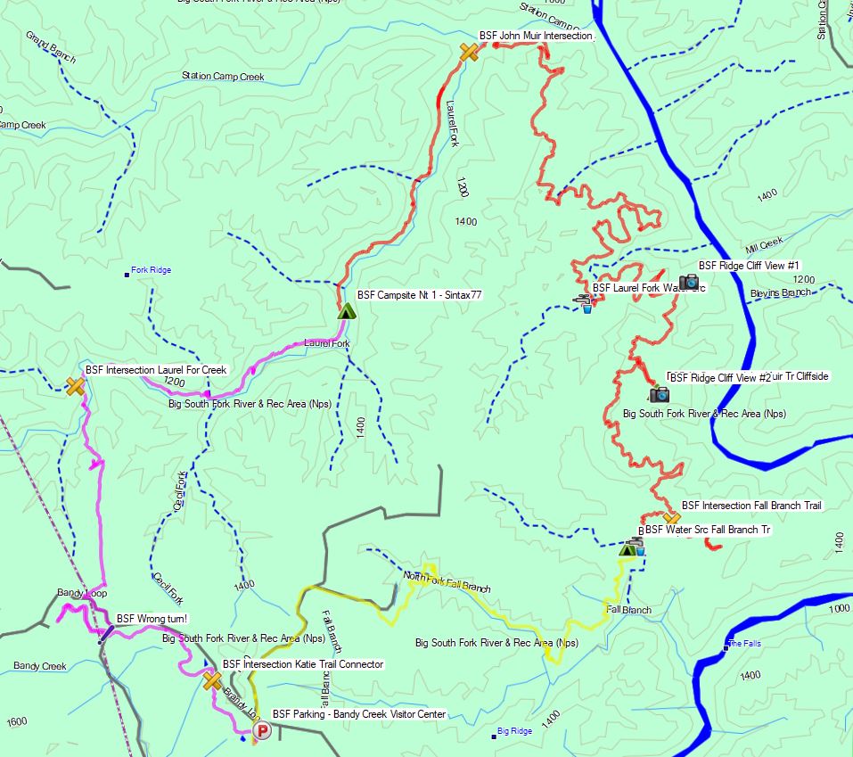
Haunted by the need to Camp in an Abandoned Place, Mike and I decide do a Backpacking Trip to the Abandoned Lyndonville Radar Station in the Remote Woods of northern Vermont.

Lyndonville AFS, also known as the North Concord Air Force Station, was a cold war era radar base that functioned as a ground control intercept and warning station from 1956 to 1963.  Built as a defensive measure against the ever growing threat of a Soviet nuclear attack, it’s mission was to provide the Strategic air Command with 24/7 data on aircraft approaching the eastern US.  Roughly 25 miles from the Canadian border, near the town of East Haven, Vermont, it’s location was chosen due to it’s far northeast orientation, under the assumption that this would be a likely attack vector for soviet nuclear bombers attacking major metropolitan areas on the east cost, including the US capitol itself.

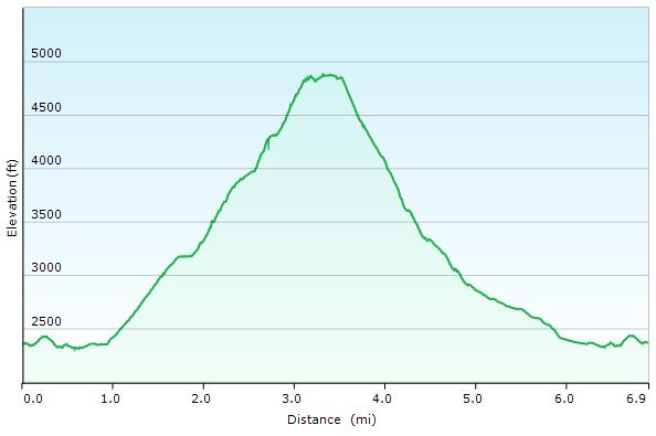
Today the base sits abandoned on the remote ridge of East Mountain, with all of it’s radar towers still standing as a reminder of the post WWII escalation that almost brought the world to it’s end.  On the upside, the views are fantastic.

Notable Gear

Mike’s YouTube Channels:

Hiking the Dix Range Pt 2 – Adirondacks 3 Day Backpacking Trip | Hammock Camping

Join Sara and I for 3 days of Hiking & Hammock Camping on a Backpacking Trip in the Adirondack’s Dix Mountain Wilderness.

For this backpacking adventure, I’ll be breaking the hiking trip into two parts. Hiking the Dix Range Part 2 is comprised of mostly hiking and summits, as we ascend from camp up onto the Dix Range to hit the Beck-Horn (a subsidiary peak of Dix Mountain) and the summit of Dix Mountain itself.

The previous Dix Range Part 1 covered our hike in to camp, setting up our base camp with our two person hammock camping system, and some campfire chat while we made a campfire, camp chores, and cook some backpacking food.

GPS Data for this trip is available on the Trip Data Page or by clicking this link for direct download: Adirondacks Dix Range Backpacking Trip 2017 – Sintax77

Trailhead and Parking Location

Elk Lake Trailhead Parking Lot, 675 Elk Lake Rd, North Hudson, NY 12855
44°01’15.0″N 73°49’40.9″W

Topics discussed and things that happen in this episode

  • A quick breakfast and discussion on where we get our Cook-in-Bags for preparing our morning oatmeal.
  • Hitting the trail towards the Adirondacks Dix Range (full trail log below)
  • Some night hiking on the descent.
  • A backpacking food taste test of AlpineAire Guacamole.

For more details on trails used for Day 1, see our Adirondacks Dix Range Part 1 Blog Post.

Trails Used Day 2

  • Set out from camp and continue north along the nearby Elk Lake to Dix Mountain Trail.
  • Get some views of Dix Pond along the way.
  • At the junction, head right (east) to ascend the Dix via Beckhorn Trail.
  • Tag Beckhorn (a subsidiary peak of Dix Mountain) for some amazing 360 views of New Yorks Adirondack Mountains.
  • Continue a short bit and tag the official summit of Dix Mountain for another round of views.
  • Begin a steep and rocky descent via the Hunters Pass Trail.
  • Rejoin the Elk Lake to Dix Mountain Trail at the junction from earlier
  • Return to base camp along the Elk Lake to Dix Mountain Trail.

Dix Range Adirondacks Day 2 Elevation Profile – Sintax77

Day 2 Total Mileage:  7 miles
Day 2 Gross Elevation Gain: 2,913 feet
Day 2 Gross Elevation Loss:  2,913 feet


Trails Used Day 3 (hike out)

  • Break camp along the Elk Lake Trail, after the Lillian Brook LT and just before the large bridge crossing Lillian Brook.  As of 9/14/17, this site had a yellow “Camp Here” disc, designating it a fully legal spot, despite it’s proximity to a small stream nearby. The stream is probably a convenient water source when flowing good, but we opted to get our water a 100 meters or so down the trail by the Lilian Brook bridge.
  • Head south on the Elk Lake to Dix Mountain Trail
  • Pass the Slide Brook Lean-to . The Slide Brook LT and camping area makes for a popular base camp for hikers hitting the Dix Range. We chose to push on a bit (under 2 miles) to the lesser used Lillian Brook lean-to area, which as some nice, legal campsites that are a bit more secluded.
  • Return to the Elk Lake Trailhead Parking Lot.  This is a decent sized lot along a gravel road on the way to the Elk Lake Lodge.  If the lot is full, you may park for free at the Elk Lake Lodge, a bit further up the road.

Day 3 Total Mileage:  3.6 miles
Day 3 Gross Elevation Gain: 354 feet
Day 3 Gross Elevation Loss:  559 feet

Full Trip 3 Day Grand Total Mileage: 14.6 miles
Full Trip 3 Day Grand Total Elevation Gain: 3,900 feet

Notable Camping / Backpacking Gear Seen on this Video

Our Dog’s Backpacking Gear

Backpacking Food

Mail Call – New Sawyer Select Water Filter & Outdoor Vitals MummyPod Hammock Sleep System

In this episode of Sintax77’s Mail Call, I check out the new Sawyer Select foam water filter, and a hammock camping sleep system by Outdoor Vitals called the StormLoft Mummy Pod, along with their netless hammock system with whoopie slings.

I also open some viewer mail and discuss Permethrin vs Picaridin vs Deet for tick and mosquito treatment of backpacking and camping gear.

Links and Info for the Sawyer Select Water Filtration System

  • Official Sawyer Select Filters Webpage Link
  • The three Select systems reduce chemicals down to 0.5 parts per billion (up to 40 times lower than the EPA’s maximum recommended level) and reduce pesticides down to 0.01 parts per billion (400 times lower than the EPA’s maximum).
  • The Select S2 and Select S3 models go even further, purifying contaminated water from suspect sources.
  • Select S2 filters out 99.99% of viruses.
  • Select S3 filters out 99.99% of viruses and reduces heavy metals such as copper, arsenic, and mercury down to 0.5 parts per billion (up to 260 times lower than the EPA’s maximum).
  • Weight: 9.25 oz total for bottle with foam filter and hollow fiber membrane filter attachment.

Links and Manufacturer’s specs for the Outdoor Vitals 15° StormLOFT Down Mummy Pod

  • Official SormLOFT MummyPod Webpage Link
  • Easily switches from use as a mummy sleeping bag to a pod system to fully insulate a hammock!
  • Patented footbox allows hammock to run straight out of the bottom of the bag and seal, or zip it up for use on the ground and insulating baffles keep your feet warm!
  • Redesigned shoulder baffles seal cold air out and add additional comfort!
  • StormLOFT™ 800 fill power hydrophobic down provides premium performance in both loft, warmth and dealing with adverse weather conditions!
  • NEW YKK Anti Snag Zipper makes it virtually impossible to damage your sleeping bag while zipping it up. It also provides easier zipper flow making it a breeze to get in and out!
  • Vertical baffles keep the down locked into place both on the hammock and on the ground.
  • Included suspension system keeps the bag from sagging or moving when using it on the hammock
  • Extra shoulder room (grid) keep the bag extremely comfortable and roomy.
  • Outdoor Vitals Lifetime Warranty: Here at Outdoor Vitals we believe in standing behind the craftsmanship and quality of our products. Anything that was our fault, we fix so you can feel confident that you’re getting exactly what you paid for!

Links and Manufacturer’s specs for the Outdoor Vitals Ultralight Solo Hammock

  • Official Outdoor Vitals Ultralight Solo Hammock Webpage
  • Weight: 14 oz (finished model may be 13 oz)
  • Hammock & Carabiners: 9.5 oz (finished model may be 8.5 oz)
  • Suspension System: 4.5 oz
  • Unfolded size: 9′ x 4′
  • Compact size: 7″ x 4.5″
  • 7/64 inch dyneema™ whoopie sling
  • 1 inch thick by 6 foot long double looped polyester tree strap
  • 40D ripstop nylon fabric
  • Triple stitched
  • Wire gate high grade aluminum carabiner
  • Rated to 300 lbs when used properly

Hiking the Dix Range Pt 1 – Adirondacks 3 Day Backpacking Trip | Hammock Camping

Join Sara and I for 3 days of Hiking & Hammock Camping on a Backpacking Trip in the Adirondack’s Dix Mountain Wilderness.

For this backpacking adventure, I’ll be breaking the hiking trip into two parts. Part 1 covers our hike in to camp, setting up our base camp with our two person hammock camping system, and some campfire chat while we make a campfire, do camp chores, and cook some backpacking food.

Hiking the Dix Range Part 2 will be comprised of mostly hiking and summits, as we ascend from camp up onto the Dix Range to hit the Beckhorn (a subsidiary peak of Dix Mountain) and the summit of Dix Mountain itself.

GPS Data for this trip is available on the Trip Data Page or by clicking this link for direct download: Adirondacks Dix Range Backpacking Trip 2017 – Sintax77

Trailhead and Parking Location

Elk Lake Trailhead Parking Lot, 675 Elk Lake Rd, North Hudson, NY 12855
44°01’15.0″N 73°49’40.9″W

Topics discussed and things that happen in this episode

  • Base camping with a ton of camping gear vs ultralight backpacking.
  • Finding & legal camping spots in the Adirondacks.
  • Pros and cons of using a bear canister. These are not legally required in the Dix Mountain Wilderness, but we had one anyway, for reasons discussed in the video.
  • Hammock camping with our dog, Denali.
  • Outfitting our Dutchware Chameleon Hammocks with the Double Dutch Bugnet system.
  • Hammock under quilt attachment using of Chameleon hammock’s underquilt hooks.
  • A look at the MalloMe Camping Cookware Set for backpacking food preparation.
  • Building a campfire and cooking some of of favorite backpacking appetizers and dinners.
  • Sara reviews a flashlight…

Trails Used Day 1

  • Parked at Elk Lake Trailhead Parking Lot.  This is a decent sized lot along a gravel road on the way to the Elk Lake Lodge.  If the lot is full, you may park for free at the Elk Lake Lodge, a bit further up the road.
  • Elk Lake to Dix Mountain Trail
  • Pass the Slide Brook Lean-to . The Slide Brook LT and camping area makes for a popular base camp for hikers hitting the Dix Range. We chose to push on a bit (under 2 miles) to the lesser used Lillian Brook lean-to area, which as some nice, legal campsites that are a bit more secluded.
  • Pass the sign for Lillian Brook LT and continue a bit further.
  • Setup camp along the Elk Lake Trail, after the Lillian Brook LT and just before the large bridge crossing Lillian Brook.  As of 9/14/17, this site had a yellow “Camp Here” disc, designating it a fully legal spot, despite it’s proximity to a small stream nearby. The stream is probably a convenient water source when flowing good, but we opted to get our water a 100 meters or so down the trail by the Lilian Brook bridge.

Dix Range Adirondacks Day 1 Elevation Profile – Sintax77

Day 1 Total Mileage:  4 miles
Day 1 Gross Elevation Gain: 633 feet
Day 1 Gross Elevation Loss:  339 feet

Notable Camping / Backpacking Gear Seen on this Video

Our Dog’s Backpacking Gear

Backpacking Food

Stay tuned for Hiking the Dix Range Part Two where we depart camp and head for ridge.

Mail Call – What is this thing? | HangTime Hook

In this episode of Sintax77’s Mail Call, I open a package containing an item that I can’t quite figure out at first…

At first glance, I could at least devise that it was some sort of hammock camping gear accessory.  Specifically what it was though, was confusing the heck out of me to be honest.

All that written on the envelope was a face book page, which cleared things up pretty quickly.   https://www.facebook.com/myhangtimehook/

Apparently it’s an early production run prototype for an accessory that allows you to easily hang your cellphone from your hammock ridgeline.  It also appears to be useful for mounting other items such as a light or USB charger as well, by using the various attachment points or the main clamp.

HangTime Hammock Ridgeline Cellphone Holder weight: 52 grams (1.83 oz)

Hiking Big South Fork Pt 2 – Tennessee Hammock Camping & Backpacking Trip

Join me for 3 days of hiking & hammock camping on a backpacking trip in Tennessee’s Big South Fork Nat’l Rec Area.

For this backpacking adventure, I’ll be breaking the hiking trip into two parts. BSF Part 1 is mostly in the woods and at camp and is more of a hanging in the woods, conversational type video. Part 2 covers days 2 and 3 where I traverse into the higher regions of Big South Fork, hitting the ridges for views of the Cumberland Plateau’s sandstone bluffs and Big South Fork River.

For more details on the first day of this trip, check out my Big South Fork Pt 1 blog post and video.

GPS Data for this trip is available on the Trip Data Page, or via this link for direct download: Big South Fork Backpacking Loop 2017 GPS Data – Sintax77

Big South Fork John Muir John Litton Backpacking Loop Route Overview – Sintax77

Trailhead and Parking Location

Bandy Creek Visitor Center, 151 Stable Rd, Oneida, TN 37841
N36° 29.275′ W84° 41.837′

Topics discussed and things that happen in this episode

  • Place Holder

Trails Used Day 2

  • Break camp along the Laurel Fork Creek Trail
  • Continue north on the Laurel Creek Fork Trail
  • Make a left (east) onto the John Muir Trail (the next 2 miles will cover the bulk of the elevation gain for the day)
  • Make a right (west) onto the Fall Branch Trail
  • Setup camp along the Laurel Fork Creek Trail (less than a 100 meters after crossing the creek / bridge.  There is a campsite immediately next to the creek as well)

Day 2 Total Mileage: 15.2 miles
Day 2 Gross Elevation Gain: 1,616 feet
Day 2 Gross Elevation Loss: 1,266 feet

Big South Fork Day 2 Elevation Profile – Sintax77

Trails Used Day 3

  • Break camp along Fall Branch Trail
  • Continue south on the Fall Branch Trail
  • Make a Right (north) onto the John Litton Farm Hike Loop Trail (heading south will ultimately bring you back to the parking lot as well).
  • Continue south onto the road (gravel, then paved) until you arrive back at the Bandy Creek Visitor Center Parking Lot.

Day 3 Total Mileage: 6.1 miles
Day 3 Gross Elevation Gain: 600 feet
Day 3 Gross Elevation Loss: 313 feet

Big South Fork Day 3 Elevation Profile – Sintax77

Trip Grand Totals

Total Mileage for Trip: 28.4 miles
Total Elevation Gain for Trip: 3,076 feet

The gear list used for this trip along with discussion on each item can be found in my accompanying 2017 Ultralight Backpacking Gear List Blog Post and Video.