Hiking Big South Fork Pt 1 – Tennessee Hammock Camping & Backpacking Trip

Join me for 3 days of hiking & hammock camping on a backpacking trip in Tennessee’s Big South Fork Nat’l Rec Area.

For this backpacking adventure, I’ll be breaking the hiking trip into two parts. Part 1 is mostly in the woods and at camp and is more of a hanging in the woods, conversational type video. In BSF Part 2 we will traverse into the higher regions of Big South Fork, hitting the ridges for views of the Cumberland Plateau’s sandstone bluffs and Big South Fork River.

GPS Data for this trip is available on the Trip Data Page or by clicking this link for direct download: Big South Fork Backpacking Loop 2017 GPS Data – Sintax77

Trailhead and Parking Location

Bandy Creek Visitor Center, 151 Stable Rd, Oneida, TN 37841
N36° 29.275′ W84° 41.837′

Topics discussed and things that happen in this episode

  • Feeling like a lost idiot on the trail.
  • Camp setup priorities when arriving at camp.
  • Setup / breaking camp in the rain.
  • Continuous Ridgeline usage and setup for quick and easy tarp deployment.
  • Low carb backpacking food options for carb conscious or ketogenic diets.
  • Starting a campfire in the rain.
  • Campfire cooking some meat on a stick.

Trails Used Day 1

  • Parked at the Bandy Creek Visitor Center
  • Started on the Oscar Blevins Farm Loop Trail (located in the corner of the parking lot on the opposite side of the road from the visitor’s center)
  • At the Intersection, turn right onto the Collier Ridge Bike Loop. This is where I mistakenly continued straight, which would have taken in a circle. Luckily, I realized earlier enough to turn around and head back to the intersection.
  • Turn left (north) on the gravel road. From looking at the map, I could have avoided the short road hike by hopping on the access Jack Ridge trail, which appears to be found either right near where I popped out on the road, or a little ways down that road to the right.  Continuing on the road seems to have saved me a decent amount of hiking though, which made up for my wrong turn earlier,
  • Turn right (east) onto the next, smaller gravel road.
  • Arrived at the sign for Jack Ridge Loop Trail and headed left onto
  • Black House Branch Trail
  • Right on Laurel Fork Creek Trail
  • Setup camp by the waterfall pool along the Laurel Fork Creek Trail.

Big South Fork Day 1 Elevation Profile – Sintax77

Day 1 Total Mileage: 7.25 miles
Day 1 Gross Elevation Gain: 860 feet
Day 1 Gross Elevation Loss: 1,256 feet

The gear list used for this trip along with discussion on each item can be found in my accompanying 2017 Ultralight Backpacking Gear List Blog Post and Video.

Train to Trail – Harpers Ferry Winter Backpacking Trip – Hiking in Virginia

Join Mike and I for for a “Train to Trail” Winter Camping, Backpacking, Campfire cooking, & Hiking adventure in Harpers Ferry, WV.

We tried something a bit different for fun on this winter camping trip – instead of driving, we decided to take an Amtrak train directly to the trailhead.  This is actually and idea that Mike and I had been kicking around for a while now.  The first challenge was finding an interesting trail that was actually close to a train station, without a need for secondary transportation or an excessive walk.  After a bit of research, we determined that Harpers Ferry, West Virginia fit the criteria quite well.  The train practically dumps you right on the Appalachian Trail.  We booked our tickets, packed our bags, and hit the trail, er, I mean, train station.

With 4 days and 3 nights off, we had a decent amount of time to play with on this trip.  The challenge however, would be that we needed to plan an out and back trip that didn’t put us to far away from the train station on our final morning, rather than doing a loop like we normally prefer.  Fortunately, we quickly realized that to be a perfect excuse to do a a laid back, more camping, less hiking  kind of trip.

The plan?  After leaving the train behind,we would hop on the Appalachian trail for a few miles – just long enough to feel the seclusion of the deep winter woods, and set up a base camp for the duration of the trip.  Other than that, we really had no hard set plans, other than relaxing, having a good time, and brushing up on our campfire cooking skills.  Did we succeed?  I guess you’ll just have to watch and see…

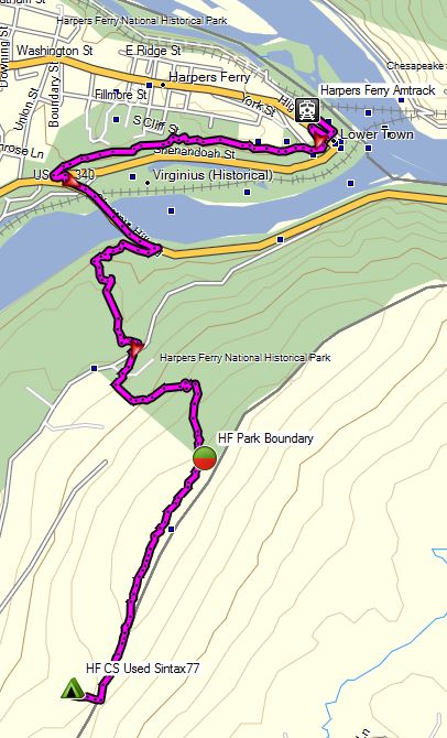
Trailhead:  Harpers Ferry Amtrak Train Station

GPS Data for this trip available on the Trip Data Page.

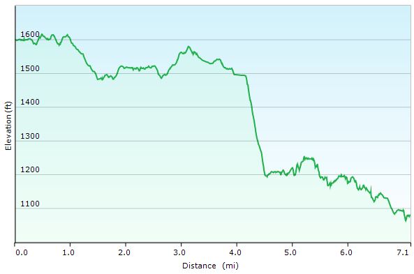
Harpers Ferry Winter Route Overview Sintax77

Harpers Ferry Winter Route Overview Sintax77

Trails Used
Leave Harpers Ferry via Appalachian Trail South
After around 3 miles, bushwack West to unofficial campsite.
Return via Appalachian Trail North

Notable Gear Used on this Trip by Mike
Gregory Palisade 80 backpack
EMS Down Parka
EMS Ascent Hard shell Jacket
MSR Whisperlite International stove
Dream Hammock Thunderbird Hammock
Hammock Gear Burrow 20 top quilt
Hammock Gear Incubator 20 underquilt
Hammock Gear Cuben Hex Tarp with doors
Portable bluetooth speaker with fancy lightshow
GSI cookset

Notable Gear Used on this Trip by Sintax77
EMS Longtrail 70 backpack (2011 version)
Montbell UL down parka
EMS Ascent Hardshell
MSR Rapidfire stove (see my video on it here) *no longer manufactured – modern equivalent is the MSR Windpro.
MSR Flex Skillet
Dollar Store tongs and turner for cooking
Sea to Summit Alpha Cutlery Set
Fozzils Bowl / Plate
Dream Hammock Darien Hammock
Hammock Gear Burrow 0 top quilt
Hammock Gear Incubator 0 underquilt
Hammock Gear Cuben Hex Tarp (standard model, no doors)
Pocket Chainsaw
SOG Flash I tanto blade pocket knife