Winter Camping and Finding a Plane Crash – Mt Success DC-3

Backpacking & Solo Winter Camping in search of a 1954 commercial airline crash near the summit of Mt Success in the White Mountains.

FTC Disclosure: This post contains affiliate links, which means I may receive a commission for purchases made through some of my links.

For this 3 day, 2 night camping trip, I headed up to a lesser traveled corner of New Hampshire’s White Mountain National Forest for some snowshoeing, camp cooking, and bit of New England aviation history.

My goal for this adventure was to find the resting place of Northeast Airlines Flight 792, which crashed on approach to Berlin Municipal Airport during inclement weather on November 30th, 1954. It made contact in the dense trees near the summit of Mt Success at an elevation of 3,390 feet.  More information on the details of Flight 792 and the circumstances of it’s survivors can be found in this copy of the official Accident Investigation Report

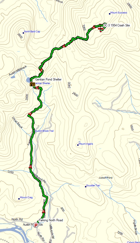
The 6.5 mile hike to get there would require a gross elevation gain of roughly 3,700 feet on potentially unbroken trail in deep snow.  The final portion of the hike would be an unofficial bushwhack through dense trees and snow.  For this reason, I chose to break up the approach up by setting up camp at roughly the halfway point along Gentian Pond and the nearby lean-to shelter with sweeping views of the Carter-Moriah mountain range.  After camping for the night, I would head up to the top of Mt Success, the first peak of the Mahoosuc Range and the Appalachian Trail’s gateway to Maine. After a few miles and a couple thousand feet of ascent with my trusty snowshoes, I would leave the trail behind in search of the DC-3.

Mt Success DC-3 Winter Backpacking Trip – Route Overview

No permit is required to backcountry camp in the White Mountains, but some locations do require a daily, weekly, or annual pass.  The parking area for this trip did not require a parking fee as of January 2021.

Full GPS track data, including campsites, water sources, etc, for this trip and many others can be downloaded on my Trip Data Page.

Trailhead Used: Austin Brook Trailhead on North Road,  44°24’45.1″N 71°04’05.4″W
North Rd, Shelburne, NH 03581

Continue reading

Fall Camping in Dolly Sods – Foliage Peaking and Sleeping Pads Leaking

Join Sara and I for 3 Days of Camp Cooking, Hiking, & Backpacking in the Dolly Sods  Wilderness.

For this 3 day, 2 night backpacking trip, Sara, Denali and I decided to do some fall foliage camping in West Virginia’s Dolly Sods Wilderness, part of the larger Monongahela National Forest. Dolly Sods is located in the Allegheny Mountains on the highest plateau east of the Mississippi river and features some of the most varied and scenic terrain available to hikers in the Mid-Atlantic region.

We had our dog with us on this trip, so we decided to give tent camping a go this time around to keep us all together in one spot.  I also decided to totally throw lightweight backpacking out the window for this trip, so I brought along my Fjallraven Kajka 75 backpack and stuffed it to the gills with various backpacking gear, just to have a little fun and switch things up a bit (gear list at end of post).  This decision was made easier by the fact that we were starting at Bear Rocks trailhead, which is already high up on the plateau with minimal elevation changes.

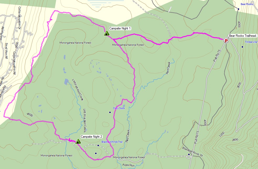
Campsites and great views are fairly abundant in Dolly Sods, so our general plan was to keep the mileage low and focus on a relaxed hiking pace, fun backpacking food and camp cooking.  It was the perfect recipe for a laid back camping trip.  Other than the whole leaking sleeping pad situation to make things more interesting…


Route Overview – Dolly Sods Fall Backpacking Loop – Sintax77

No permit is required to camp in the Dolly Sods Wilderness, but there are rules and regulations regarding backcountry camping. You can find more information on the USFS Dolly Sods website here.

Full GPS track data, including campsites, water sources, etc, for this trip and many others can be downloaded on my Trip Data Page.

Continue reading

Hiking Halfmoon Mountain – Camping & Backpacking in West Virginia

Solo Backpacking, Hiking, & Camping with my Dog on the Halfmoon Mountain Loop in West Virginia.

For this 2 day, 1 night spring backpacking trip, I’ll be hiking a 10.5 mile loop in the George Washington National Forest.

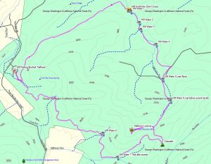
Route Overview – Halfmoon Mountail Loop – Sintax77

No permit is required to camp in the George Washington National forest, but there are rules and regulations regarding backcountry camping. You can find more information on the George Washington & Jefferson National Forest website here.

Full GPS track data, including campsites, water sources, etc, for this trip and many others can be downloaded on my Trip Data Page.

Continue reading

GCI Slim Fold Cook Station – Make your Vehicle Adventure Ready

A Review of the GCI Outdoor Slim Fold Cook Station.

In this video camping fear review, I give a run down of the various features of the GCI Slim Fold Camp Cook Station, as well as my own personal experiences with the GCI cook station for car camping and various camp cooking applications.

Disclosure: This post or video contains affiliate links, which means I may receive a commission for purchases made through my links. Cross reference, do your own research and make your own decisions, duh 😉

Specs and Features as per the manufacturer

  • Folds flat for storage
  • Easy to open, set up and close
  • Four multi-use fold-out side tables – beverage, wine glass, garbage bag, paper towel and utensil holder (weight limit per table: 30 lb / 13.6 kg)
  • Aluminum counter top (weight limit: 48 lb / 21.8 kg)
  • Lower rack for storage/dry goods (weight limit: 35 lb / 15.9 kg)
  • Powder-coated steel frame
  • Open size: 20.9 x 52 x 32.3 in (53 x 132 x 82 cm)
  • Folded size: 20.9 x 3.7 x 34.6 in (53 x 9.5 x 88 cm)
  • Unit weight: 18.9 lb (8.6 kg)

MalloMe Camping Cookware Mess Kit Review

A Review of the MalloMe Camping Cookset.

The MalloMe Cookware set is a 10 piece nesting mess kit for backpacking and camping that I’ve had for about year now, with great results.

While I typically pack pretty minimal for my solo backpacking trips, for group backpacking trips and snow melting in the winter, I’ve grown to really like this budget mess kit. It’s also quite nice for more involved backpacking meals and trail food cooking.

Items included with the MalloMe Cookware Set

  • Aluminum 1 Liter Pot
  • Pot Lid
  • Aluminum Frying Pan
  • 2 BPA Free Bowls
  • Folding Stainless Steel Spork
  • BPA Free Soup Spoon / Ladel
  • Wooden Spoon Spatula
  • Cleaning Sponge
  • Folding Stainless Steel Fork (free bonus)
  • Nylon Travel Bag Drawstring Pouch

Other Trail & Backpacking Cooking Items Seen

Toaks 450ml titanium cup
Toaks 750ml titanium cook pot 
Sea To Summit Alpha Light Long Spoon
Budget Canister Stove

Hiking Big South Fork Pt 2 – Tennessee Hammock Camping & Backpacking Trip

Join me for 3 days of hiking & hammock camping on a backpacking trip in Tennessee’s Big South Fork Nat’l Rec Area.

For this backpacking adventure, I’ll be breaking the hiking trip into two parts. BSF Part 1 is mostly in the woods and at camp and is more of a hanging in the woods, conversational type video. Part 2 covers days 2 and 3 where I traverse into the higher regions of Big South Fork, hitting the ridges for views of the Cumberland Plateau’s sandstone bluffs and Big South Fork River.

For more details on the first day of this trip, check out my Big South Fork Pt 1 blog post and video.

GPS Data for this trip is available on the Trip Data Page, or via this link for direct download: Big South Fork Backpacking Loop 2017 GPS Data – Sintax77

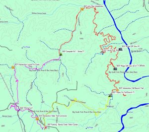
Big South Fork John Muir John Litton Backpacking Loop Route Overview – Sintax77

Trailhead and Parking Location

Bandy Creek Visitor Center, 151 Stable Rd, Oneida, TN 37841
N36° 29.275′ W84° 41.837′

Topics discussed and things that happen in this episode

  • Place Holder

Trails Used Day 2

  • Break camp along the Laurel Fork Creek Trail
  • Continue north on the Laurel Creek Fork Trail
  • Make a left (east) onto the John Muir Trail (the next 2 miles will cover the bulk of the elevation gain for the day)
  • Make a right (west) onto the Fall Branch Trail
  • Setup camp along the Laurel Fork Creek Trail (less than a 100 meters after crossing the creek / bridge.  There is a campsite immediately next to the creek as well)

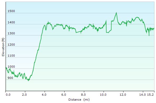
Day 2 Total Mileage: 15.2 miles
Day 2 Gross Elevation Gain: 1,616 feet
Day 2 Gross Elevation Loss: 1,266 feet

Big South Fork Day 2 Elevation Profile – Sintax77

Trails Used Day 3

  • Break camp along Fall Branch Trail
  • Continue south on the Fall Branch Trail
  • Make a Right (north) onto the John Litton Farm Hike Loop Trail (heading south will ultimately bring you back to the parking lot as well).
  • Continue south onto the road (gravel, then paved) until you arrive back at the Bandy Creek Visitor Center Parking Lot.

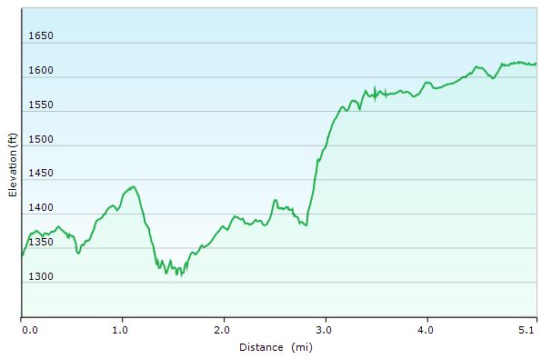
Day 3 Total Mileage: 6.1 miles
Day 3 Gross Elevation Gain: 600 feet
Day 3 Gross Elevation Loss: 313 feet

Big South Fork Day 3 Elevation Profile – Sintax77

Trip Grand Totals

Total Mileage for Trip: 28.4 miles
Total Elevation Gain for Trip: 3,076 feet

The gear list used for this trip along with discussion on each item can be found in my accompanying 2017 Ultralight Backpacking Gear List Blog Post and Video.