Hammock Camping with my Dog – Seneca Creek Hiking & Backpacking Trip

Join my dog Denali and I for some Hiking, Backpacking, and Hammock Camping in the Seneca Creek Backcountry.

For this hiking adventure, my pup and I will be visiting the Spruce Knob-Seneca Creek National Recreation area, within West Virginia’s greater Monongahela National Forest. Our route will be a “lollipop”style hike – meaning we’ll use an “out and back” section of trail from the Spruce Knob trailhead parking area to connect with a series of other trails that form a loop. After completing the loop portion of the hike, we’ll backtrack out using the same section of trail from day one.

The Spruce Knob-Seneca Creek Backcountry offers around 60 miles of trails (marked with blue blazes) with an elevation range of 3,000 to 4,800 feet above sea level. The beginning of this particular loop is actually the highest point in all of West Virginia – Spruce Knob – standing at and elevation of 4,861 feet. Below is a list of trails for each day, along with stats for elevation gain and mileage.

Trailhead Parking: Spruce Knob Parking area (right by the observation tower).

Parking Notes:  No parking fees or overnight permits are required.  There are restrooms and bear-proof trash bins available for use.

GPS Track Data for this trip can be found on my Trip Data Page.

Trails used, Day 1

  • Huckleberry Trail
  • Hornton Trail (just for a short bit)
  • Judy Springs Trail
  • Seneca Creek Trail
  • Hammock Camp along Seneca Creek.

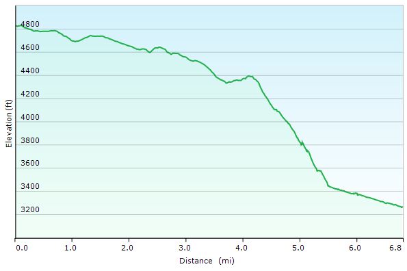
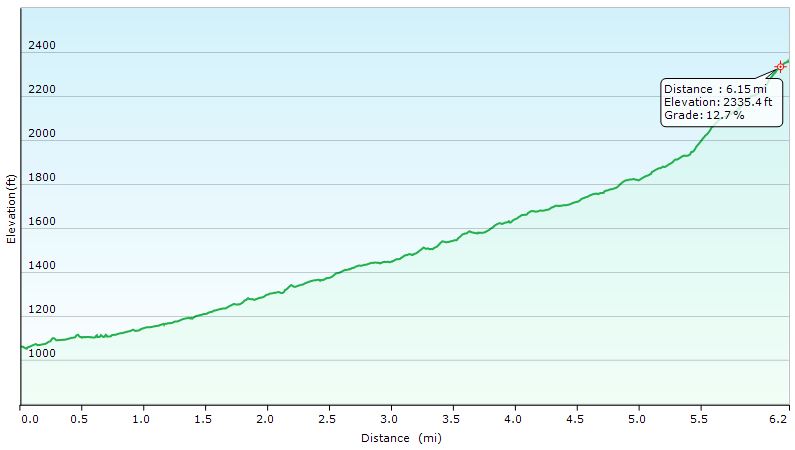
Day 1 – Seneca Creek Loop elevation Profile – Sintax77

Day 1 Mileage: 6.5 miles
Day 1 Gross Elevation Gain:  221 feet (pretty much down hill all day)

Trails used, Day 2

  • Seneca Creek Trail
  • High Meadows Trail
  • Lumberjack Trail
  • Join back up with Huckleberry Trail
  • Arrive back at Spruce Knob Parking Lot

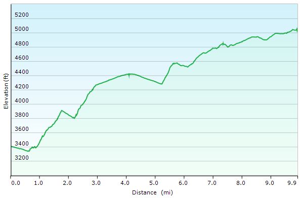
Day 2 – Seneca Creek Loop elevation Profile – Sintax77

Day 2 Mileage: 10 miles
Day 2 Gross Elevation Gain:  2,173 feet (pretty much up hill all day)

Notable Gear Seen in the Video

Denali’s Hammock – 2T’s Hammock Chair from Dutchware
Denali’s Dog Backpack – “One Tigris Cotton Canvas Dog Pack”
Denali’s Collapsible Dog Dish – Doggone Dish
Dutchware Chameleon Hammock
Hammock Gear Burrow 40 Top Quilt

Hammock Gear Phoenix 30 Underquilt
Hammock Gear Cuben Hex Tarp
Katadyn BeFree Water Filter
Toaks 750ml Titanium Pot
Vargo Windscreen
Esbit Solid Fuel Cubes
ULA Ohm 2.0 Backpack

Aerial Photography – DJI Mavic Pro
Primary Camera – Blackmagic Pocket Cinema Camera

Catskills Hiking & Trail Pizza – Backpacking with our Dog

Join Sara, our dog Denali, & I for some Catskills hiking, trail cooking, backpacking, and hammock camping in upstate New York.

For this backpacking trip, we’ll be hiking and camping near Slide Mountain and the East Branch Neversink River in the Catskills, complete with a visit to the summit of Table Mountain and Peekamoose Moose Mountain.  The mileage will be low, but the star of this trip isn’t the trails.  It’s the food.  Good old, classic trail cooking.

What’s on our backpacker’s menu?  Well, Sara had a craving for some trail pizza in the middle of the woods somewhere, and I was up for the challenge.  Were we successful?  You’ll just have to come along and find out.  Either way, it’s bound to be an adventure.  😉

Full GPS data for this, as well as all of my other trips, is available on the Trip Data page.

Trailhead Used:  
Denning Rd Trailhead  N41° 57.924′ W74° 27.144′


Trails Used Day 1, in Order

Pheonicia East Branch Trail
Peekamoose Table Trail
Set up camp after second bridge (the double log one) at N41° 58.474′ W74° 25.734′
Continue up Peekamoose Table Trail towards summit of
Table Mt and Peekamoose Mountain
Lunch / Snack at summit and
Return to camp on the East Branch Neversink River

Day 1 Mileage: 7.8 miles, including summit round trip (about 3 miles each way)
Day 1 Gross Elevation Gain: 2,130′

Trails Used Day 2, in Order

Peekamoose Table Trail
Pheonicia East Branch Trail
Return to vehicle at Denning Rd Trailhead

Day 2 Mileage: 1.8 miles
Day 2 Gross Elevation Gain: 
146′

Trip Total Mileage: 9.6 miles
Trip Total Elevation Gain: 2,276


Trail Pizza 
Ingredients

Boboli Pizza Crust, Individual Size – 2 Pack
Boboli Pizza Sauce Individual Pack (comes in 3 pack box)
Cabot Mozzarella Cheese, Shredded – 8 oz package (2 cups volume)
Hormel Pepperoni, pre-sliced – 6 oz package (enough for 2 pizzas, plus snacking)
Camp Cooking Gear Used for Pizza

Pair of cheap aluminum tongs (from dollar store, or whatever)
Coghlan’s Camp Grill  – rack used to hold pizza
Fozzils Bowlz (used as a plate / prepping dish / cutting board)
Sea-to-Summit Alpha Utensil Set

Denali’s First Hike – Backpacking with our Dog

Join Sara and I as we take our puppy, Denali, on his very first backpacking trip.

For this adventure, we were joined by a brand new hiking partner – our 7 month old puppy dog, Denali.  While Denali is no stranger to walking and hiking (we’ve tried to make that a regular part of his life since we adopted him at 2 months old), this will be his very first foray into an overnight backpacking trip.  Or to put it in terms from his perspective; his first time sleeping out in the woods, seemingly in the middle of nowhere, nary a shred of carpet or plush dog bed to be seen.

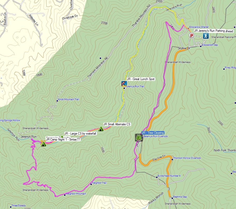
Denali's First Backpacking Trip Route Overview - Sintax77

Denali’s First Backpacking Trip Route Overview – Sintax77

Our chosen destination was a 14 mile loop comprised of several trails in Virginia’s Shenandoah National Park.  I was made aware of this trip via the super-helpful website called “Hiking Upward”.  For those of you hikers along the mid-Atlantic who haven’t heard of this site before, I highly suggest checking it out some time.  Since this was a bit of a last minute trip, coupled with the fact that it was our pup’s first time backpacking, I wanted everything to go nice and smoothly, and their detailed trip reports were a welcomed asset.

The first half of this circuit was of the higher elevation variety, consisting primarily of a ridge walk along a the Neighbor Mountain Trail, as well as a section of the Appalachian Trail.  Day two would be mostly along the Jeremy’s Run Trail.  As the name would suggest, the Jeremy’s run trail closely follows the contours of Jeremy’s Run, a stream that we would traverse 14 times before returning to the metallic confines of our car.  Below is an overview of our route, along with trailhead parking ocation and other points of interest.  For those of you interested, I recorded full GPS track data during this backpacking trip. along with campsites and other notable POI’s which can be downloaded on my Trip Data page.

Trailhead and Parking: Jeremy’s Run Trailhead N38° 44.456′ W78° 18.716′ (by Elkwallow Picnic Gound and the Wayside Store)

Trails Used Day 1 (in order)
Starting from the Jeremy’s Run Trailhead,
Take the Appalachian Trail (south)
Turn right (west) on Neighbor Mountain Trail
At intersection, turn right (east) on Jeremy’s Run Trail
Set-up camp along Jeremy’s Run at N38° 42.629′ W78° 21.913′

Day 1 Total Mileage:  9 miles (This is the mileage to the actual campsite. My solo mileage for the day, including scouting and backtracking, totaled 13.5 miles)
Day 1 Total Elevation Gain: 1,785′

Denali's First Backpacking Trip Day 1 - Sintax77

Denali’s First Backpacking Trip Day 1 – Sintax77


Trails Used Day 2 (in order)
Continue on Jeremy’s Run Trail
At intersection, continue north on Appalachian Trail
back to the Jeremy’s Run Parking Trailhead and parking area.

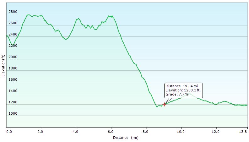
Day 2 Total Mileage:  6 miles
Day 2 Total Elevation Gain: 1,391′

Total Mileage for Trip: 15 miles
Total Elevation Gain for Trip:  3,176′

Denali's First Backpacking Trip Day 2 - Sintax77

Denali’s First Backpacking Trip Day 2 – Sintax77