50 Miles of Hammock Camping in 3 Days – Backpacking on Cranberry Lake

3 days of Backpacking & Hammock Camping along Cranberry Lake in the Adirondacks

FTC Disclosure: This post contains affiliate links, which means I may receive a commission for purchases made through some of my links.

For this adventure, I decided to do a fall backpacking trip with some higher trail mileage than I’ve been doing lately. Nestled in New York’s Five Pond Wilderness, the Cranberry Lake 50 is a fifty mile loop hike that circumnavigates it’s namesake, and passes by many smaller ponds along the way as well. Most of these smaller ponds have campsites or even a lean-to shelter nearby, which is quite nice.

The CL50 is not really an individual trail, but a collection of trail sections from 12 other trails is the area.  The route is well blazed with blue CL50 plastic discs nailed to trees along the way.  The trails used to make up the CL50 are blazed with similar yellow trail discs, so you will often see both blazes simultaneously.

The Cranberry Lake 50 goes directly through two towns – Wanakena, where I started, and the town of Cranberry Lake.  There’s only about 10 trail miles between them, so neither really poses much logistical value for resupplying, but they are nice towns to stroll through.

I chose to do the loop counter clockwise from Wanakena because the last 10 miles traverse some muddy wet sections due to beaver dams, so I figured it would be best to save that for the last afternoon.

I typically like to hike my backpacking trips on a 3 day, 2 night timeline, so that meant my daily trail mileage had to be around 17 miles or so during the shortened daylight hours of October.  On the upside, this hike is primarily along the perimeter of a lake, with minimal elevation changes, but did I mention that I hadn’t done a high mileage trip in a while? Yeah, the headlamp got a good amount of usage on this one. Let the night hiking begin…

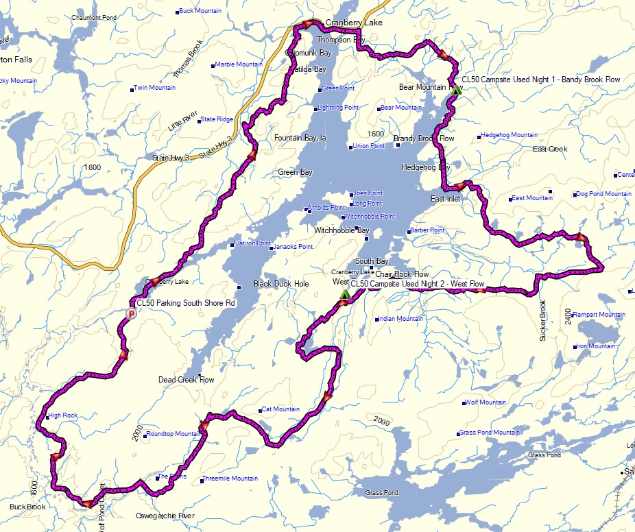
Route Overview – Cranberry Lake 50 Backpacking Loop – Sintax77

Continue reading

Military Surplus Camping – B-47 Crash Site – Adirondack Mountains

Hiking & Backpacking with Military Surplus Camping Gear in the Adirondacks Eastern High Peaks Region

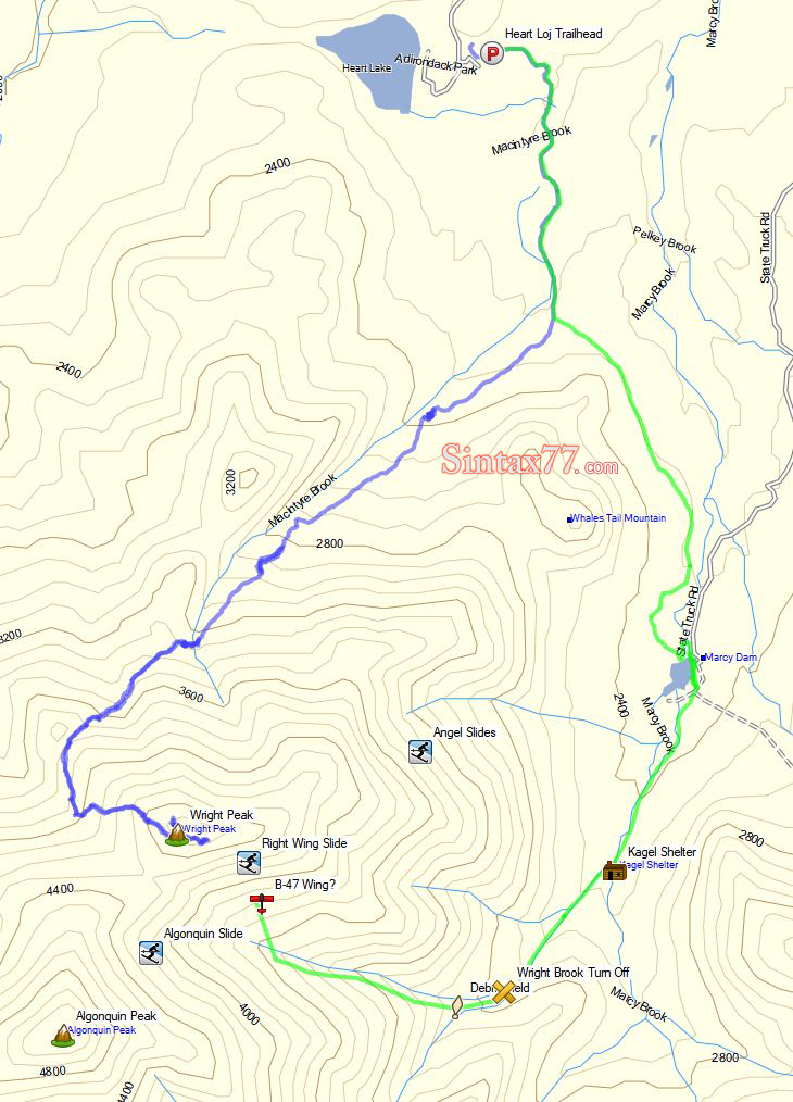
For this 2 day, 1 night adventure, I’ll be testing out and demonstrating my milsurp backpacking load-out, along with MRE (Meals Ready to Eat) food to keep me fueled up while I search for the remnants of a cold war era B-47 bomber that crashed on Wright Peak during the night of January 2nd, 1962.

My “big 3” for this backpacking trip are a medium sized ALICE pack, USGI Modular Sleeping bag with USGI Term-A-Rest sleeping Pad, and a USGI Poncho for shelter / rain gear. I scored each of these items for around $30.  A full gear list can be found at the end of this post.

No permit is required to camp in the Adirondacks, but there are rules and regulations regarding backcountry camping. You can find more information here.

Continue reading

Hiking the Dix Range Pt 2 – Adirondacks 3 Day Backpacking Trip | Hammock Camping

Join Sara and I for 3 days of Hiking & Hammock Camping on a Backpacking Trip in the Adirondack’s Dix Mountain Wilderness.

For this backpacking adventure, I’ll be breaking the hiking trip into two parts. Hiking the Dix Range Part 2 is comprised of mostly hiking and summits, as we ascend from camp up onto the Dix Range to hit the Beck-Horn (a subsidiary peak of Dix Mountain) and the summit of Dix Mountain itself.

The previous Dix Range Part 1 covered our hike in to camp, setting up our base camp with our two person hammock camping system, and some campfire chat while we made a campfire, camp chores, and cook some backpacking food.

GPS Data for this trip is available on the Trip Data Page or by clicking this link for direct download: Adirondacks Dix Range Backpacking Trip 2017 – Sintax77

Trailhead and Parking Location

Elk Lake Trailhead Parking Lot, 675 Elk Lake Rd, North Hudson, NY 12855
44°01’15.0″N 73°49’40.9″W

Topics discussed and things that happen in this episode

  • A quick breakfast and discussion on where we get our Cook-in-Bags for preparing our morning oatmeal.
  • Hitting the trail towards the Adirondacks Dix Range (full trail log below)
  • Some night hiking on the descent.
  • A backpacking food taste test of AlpineAire Guacamole.

For more details on trails used for Day 1, see our Adirondacks Dix Range Part 1 Blog Post.

Trails Used Day 2

  • Set out from camp and continue north along the nearby Elk Lake to Dix Mountain Trail.
  • Get some views of Dix Pond along the way.
  • At the junction, head right (east) to ascend the Dix via Beckhorn Trail.
  • Tag Beckhorn (a subsidiary peak of Dix Mountain) for some amazing 360 views of New Yorks Adirondack Mountains.
  • Continue a short bit and tag the official summit of Dix Mountain for another round of views.
  • Begin a steep and rocky descent via the Hunters Pass Trail.
  • Rejoin the Elk Lake to Dix Mountain Trail at the junction from earlier
  • Return to base camp along the Elk Lake to Dix Mountain Trail.

Dix Range Adirondacks Day 2 Elevation Profile – Sintax77

Day 2 Total Mileage:  7 miles
Day 2 Gross Elevation Gain: 2,913 feet
Day 2 Gross Elevation Loss:  2,913 feet


Trails Used Day 3 (hike out)

  • Break camp along the Elk Lake Trail, after the Lillian Brook LT and just before the large bridge crossing Lillian Brook.  As of 9/14/17, this site had a yellow “Camp Here” disc, designating it a fully legal spot, despite it’s proximity to a small stream nearby. The stream is probably a convenient water source when flowing good, but we opted to get our water a 100 meters or so down the trail by the Lilian Brook bridge.
  • Head south on the Elk Lake to Dix Mountain Trail
  • Pass the Slide Brook Lean-to . The Slide Brook LT and camping area makes for a popular base camp for hikers hitting the Dix Range. We chose to push on a bit (under 2 miles) to the lesser used Lillian Brook lean-to area, which as some nice, legal campsites that are a bit more secluded.
  • Return to the Elk Lake Trailhead Parking Lot.  This is a decent sized lot along a gravel road on the way to the Elk Lake Lodge.  If the lot is full, you may park for free at the Elk Lake Lodge, a bit further up the road.

Day 3 Total Mileage:  3.6 miles
Day 3 Gross Elevation Gain: 354 feet
Day 3 Gross Elevation Loss:  559 feet

Full Trip 3 Day Grand Total Mileage: 14.6 miles
Full Trip 3 Day Grand Total Elevation Gain: 3,900 feet

Notable Camping / Backpacking Gear Seen on this Video

Our Dog’s Backpacking Gear

Backpacking Food

Hiking the Dix Range Pt 1 – Adirondacks 3 Day Backpacking Trip | Hammock Camping

Join Sara and I for 3 days of Hiking & Hammock Camping on a Backpacking Trip in the Adirondack’s Dix Mountain Wilderness.

For this backpacking adventure, I’ll be breaking the hiking trip into two parts. Part 1 covers our hike in to camp, setting up our base camp with our two person hammock camping system, and some campfire chat while we make a campfire, do camp chores, and cook some backpacking food.

Hiking the Dix Range Part 2 will be comprised of mostly hiking and summits, as we ascend from camp up onto the Dix Range to hit the Beckhorn (a subsidiary peak of Dix Mountain) and the summit of Dix Mountain itself.

GPS Data for this trip is available on the Trip Data Page or by clicking this link for direct download: Adirondacks Dix Range Backpacking Trip 2017 – Sintax77

Trailhead and Parking Location

Elk Lake Trailhead Parking Lot, 675 Elk Lake Rd, North Hudson, NY 12855
44°01’15.0″N 73°49’40.9″W

Topics discussed and things that happen in this episode

  • Base camping with a ton of camping gear vs ultralight backpacking.
  • Finding & legal camping spots in the Adirondacks.
  • Pros and cons of using a bear canister. These are not legally required in the Dix Mountain Wilderness, but we had one anyway, for reasons discussed in the video.
  • Hammock camping with our dog, Denali.
  • Outfitting our Dutchware Chameleon Hammocks with the Double Dutch Bugnet system.
  • Hammock under quilt attachment using of Chameleon hammock’s underquilt hooks.
  • A look at the MalloMe Camping Cookware Set for backpacking food preparation.
  • Building a campfire and cooking some of of favorite backpacking appetizers and dinners.
  • Sara reviews a flashlight…

Trails Used Day 1

  • Parked at Elk Lake Trailhead Parking Lot.  This is a decent sized lot along a gravel road on the way to the Elk Lake Lodge.  If the lot is full, you may park for free at the Elk Lake Lodge, a bit further up the road.
  • Elk Lake to Dix Mountain Trail
  • Pass the Slide Brook Lean-to . The Slide Brook LT and camping area makes for a popular base camp for hikers hitting the Dix Range. We chose to push on a bit (under 2 miles) to the lesser used Lillian Brook lean-to area, which as some nice, legal campsites that are a bit more secluded.
  • Pass the sign for Lillian Brook LT and continue a bit further.
  • Setup camp along the Elk Lake Trail, after the Lillian Brook LT and just before the large bridge crossing Lillian Brook.  As of 9/14/17, this site had a yellow “Camp Here” disc, designating it a fully legal spot, despite it’s proximity to a small stream nearby. The stream is probably a convenient water source when flowing good, but we opted to get our water a 100 meters or so down the trail by the Lilian Brook bridge.

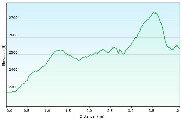
Dix Range Adirondacks Day 1 Elevation Profile – Sintax77

Day 1 Total Mileage:  4 miles
Day 1 Gross Elevation Gain: 633 feet
Day 1 Gross Elevation Loss:  339 feet

Notable Camping / Backpacking Gear Seen on this Video

Our Dog’s Backpacking Gear

Backpacking Food

Stay tuned for Hiking the Dix Range Part Two where we depart camp and head for ridge.