Join Sara and I for 3 Days of Camp Cooking, Hiking, & Backpacking in the Dolly Sods Wilderness.
For this 3 day, 2 night backpacking trip, Sara, Denali and I decided to do some fall foliage camping in West Virginia’s Dolly Sods Wilderness, part of the larger Monongahela National Forest. Dolly Sods is located in the Allegheny Mountains on the highest plateau east of the Mississippi river and features some of the most varied and scenic terrain available to hikers in the Mid-Atlantic region.
We had our dog with us on this trip, so we decided to give tent camping a go this time around to keep us all together in one spot. I also decided to totally throw lightweight backpacking out the window for this trip, so I brought along my Fjallraven Kajka 75 backpack and stuffed it to the gills with various backpacking gear, just to have a little fun and switch things up a bit (gear list at end of post). This decision was made easier by the fact that we were starting at Bear Rocks trailhead, which is already high up on the plateau with minimal elevation changes.
Campsites and great views are fairly abundant in Dolly Sods, so our general plan was to keep the mileage low and focus on a relaxed hiking pace, fun backpacking food and camp cooking. It was the perfect recipe for a laid back camping trip. Other than the whole leaking sleeping pad situation to make things more interesting…
No permit is required to camp in the Dolly Sods Wilderness, but there are rules and regulations regarding backcountry camping. You can find more information on the USFS Dolly Sods website here.
Full GPS track data, including campsites, water sources, etc, for this trip and many others can be downloaded on my Trip Data Page.
Trailhead Used: Bear Rocks Trailhead, N39° 03.794′ W79° 18.197′
Public Rd 75, Davis, WV 26260
The Bear Rocks trailhead has room for many vehicles and is reached via a dirt / gravel road. The grade is not too aggressive and should be fine for most 2wd cars if driven carefully (I saw a couple when I was there). No parking fee or permit required. Loop begins behind the large info board.
Dolly Sods Printable Trail Map from the USFS
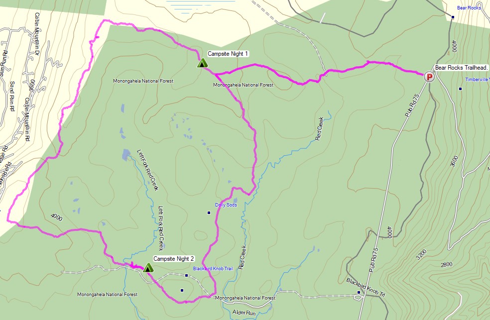
Trails Used, Day 1
- Bear Rocks Trail
- Straight (west) on Raven Ridge Trail
- Camp along the Raven Ridge Trail near the intersection with Beaver View Trail
- There are multiple small to large sized camping spots on both sides of Raven Ridge and Beaver View Trails. . Many of them have nice established fire rings with rocks for camp stoves, etc. and even the occasional rock chair! There are no reliable streams in the direct vicinity, so make sure to pack in water.
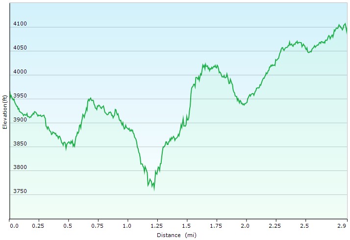
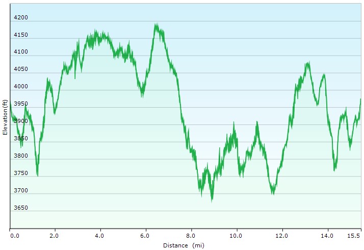
Day 1 Mileage: 3 miles
Day 1 Gross Elevation Gain: 598 feet
Trails Used, Day 2
- Continue on Raven Ridge Trail
- Left (south) on Rocky Ridge Trail
- Left (east) on Harman Trail
- Left (east) Blackbird Knob Trail
- Camp along the Blackbird Knob Trail near the crossing of Upper Red Creek
- This area has an abundance of potential campsites, some directly along the river, others tucked farther back into the woods. The campsite we used was on a hill and wasn’t the best spot for a tent, but we chose it because the creek area was busy and we wanted some extra warmth outside of the pines.
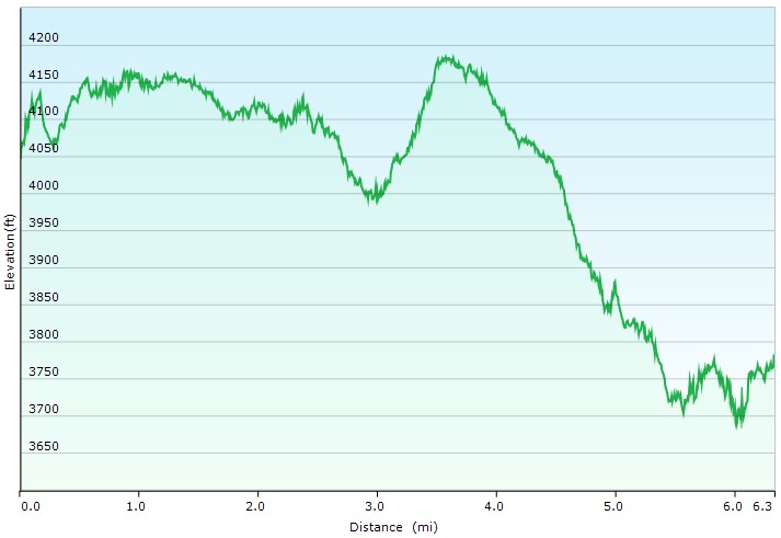
Day 2 Mileage: 6 miles
Day 2 Gross Elevation Gain: 1,201 feet
Trails Used, Day 3
- Continue east on the Blackbird Knob Trail
- Left (north) on Upper Red Creek Trail
- Right (south) on Dobbin Grade Trail (only for 1/10 mile)
- Right (north) on Raven Ridge Trail
- I highly suggest not staying on the Dobbin Grade trail. While it is a shorter route back to the parking lot, the trail traverses very boggy terrain, sometimes waist deep. Raven Ridge is much drier and more scenic as well.
- Right (east) on Bear Rocks Trail
- Return to the Bear Rocks parking area.
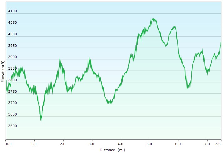
Day 3 Mileage: 7.5 miles
Day 3 Gross Elevation Gain: 1,412 feet
Grand Total Mileage: 16.5 Miles
Grand Total Gross Elevation Gain: 3,211 feet
Notable Backpacking Gear
- Sara’s ULA Ohm 2.0 Backpack
- My Fjallraven Kajka 75 Backpack
- Ozark Trails 4 Person Dome Tent
- Dutchware Xenon 2 Person Tarp
- Hammock Gear Burrow 40 & 20 Top Quilts
- Unigear Sleeping Pad
- Dutchware UP Booties
- MalloMe Camp Cookset and Stove Combo
- Generic Cannister Stove
- Light My Fire Mini Fire Steel Striker
- Sea to Summit Long Handled Spork
- Potable Aqua Water Purification Tablets
- Sara’s Outdoor Research Helium III Rain Jacket
- Shawn’s Marmot Eclipse Hardshell Jacket
- Outdoor Vitals Adventure Jacket, Loftek version
- Outdoor Vitals Satu Adventure Pants
- La Sportiva Wildcat Trail Running Shoes
- Wright Socks (I love these for blister prevention, particularly in wet conditions).
- Dutchware Folding Sit Pad
- Byer of Maine Trilite Camp Stool
- Nitecore NU25 Headlamp
- Garmin Oregon 650 GPS unit
- Casio ProTrek F30 Smartwatch
- Benchmade Bugout EDC Folding Knife
- Peak Refuel Backpacking Meals
Camera and Nav Gear used for this episode
- GoPro Hero 8 Black
- GoPro Shorty Tripod Grip
- 128GB Sandisk Extreme Memory Card
- Spot Gen3 GPS Messenger & SOS device
FTC Disclosure: This post contains affiliate links, which means I may receive a commission for purchases made through some of my links.

