Vermont Long Trail Section Hike – Camping at Stark’s Nest

Section Hiking on the Vermont Long Trail – Appalachian Gap to Lincoln Gap.

For this backpacking trip, my dog Denali and I will be doing a 2 day, 1 night camping trip in Northern Vermont.  The specific area we’ll be camping near is called the Stark’s Nest, which lies on a section of the Long Trail between Appalachian Gap and Lincoln Gap, about 40 minutes west of Montpelier, VT.

As seen in the video, use this link to get your free camping pillow from Outdoor Vitals for a limited time.

The Vermont Long Trail is a 273 mile, long distance hiking trail that runs the entire length of Vermont, from the sothern border with Massachusetts all the way up to the Canadian border to the north.  The first hundred miles or so in the south coincide with the Appalachian Trail as well.  I’ll be backpacking and camping just a short taste of the Long Trail – a roughly 8 mile section in the North Country of Vermont on a combination of private land and Vermont’s Green Mountain National Forest.

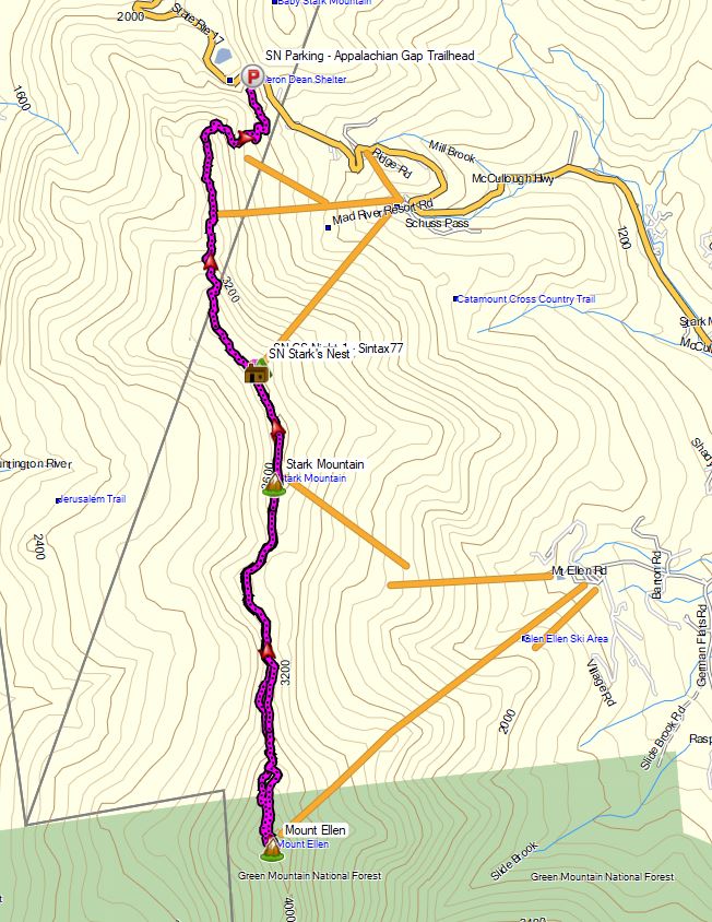
Starks Nest Hike – Route Overview – Sintax77

GPS Data for this trip and many others can be found on my Trip Data Page.  Includes full track data for each day, and way-points for campsites used, water sources, etc.

Trailhead Used: Appalachian Gap Trailhead Parking Area  – 44°12’39.7″N 72°55’53.5″W
This is a large, paved parking area just off of Vermont SR17.  The Vermont Long Trail South (which I took in the video) can be found on the opposite side of the road.  The Long Trail North (which I didn’t take) is located right in the corner of the lot, by the guard rail.

Trails Used & Itinerary, Day 1

  • Park at the Appalachian Gap Trailhead Parking Area
  • Take the Vermont Long Trail South (located on the other side of the road. Look for the white blaze
  • Arrive at Stark’s Nest warming hut and grab some water from the rain barrel.
    Note: Stark’s Nest is a ski warming hut. During the winter, this is a hut used to take a break and warm up in between ski runs at Mad River Glen Ski Resort. While this is private property, it is kept open and available to hikers year round as a place to take a break, or camp for the night while hiking the Vermont Long Trail. There is a rain barrel out front that makes for an excellent water source. It’s essentially a fully enclosed cabin that makes it a great option for riding out storms and bad weather. There is a composting outhouse nearby, across from the cabin in the woods opposite the cabin.
  • Set up camp a little ways down the ski slope near Stark’s Nest

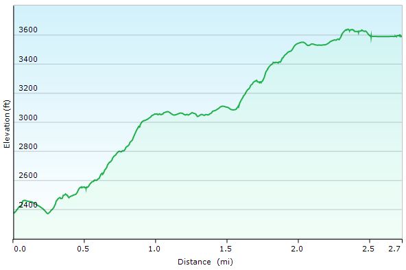
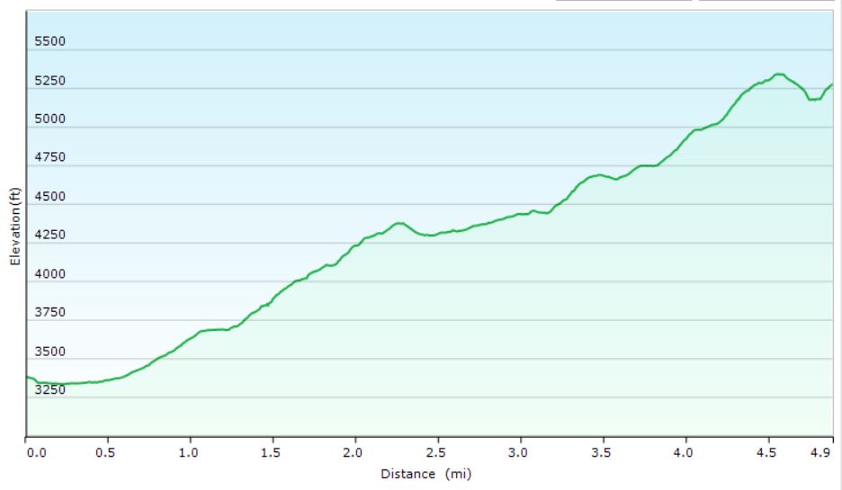
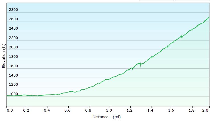
Starks Nest Hike Day 1 – Elevation Profile

Day 1 Mileage: 3 miles
Day 1 Gross Elevation Gain: 1,501′
Day 1 Gross Elevation Descent: 283′

Trails Used, Itinerary Day 2

  • Leave camp and head back uphill to the Stark’s Nest.
  • Continue south on the Vermont Long Trail.
  • End at the ski lift area on Mt Ellen for a break and some views.
  • Backtrack out the way you came, via the Long Trail North.
  • Arrive back at the Stark’s Nest.
  • Breakdown camp, pack up and replenish water supplies.
  • Backtrack out on the Vermont Long Trail North.
  • Arrive back at the Appalachian Gap Trailhead Parking area.

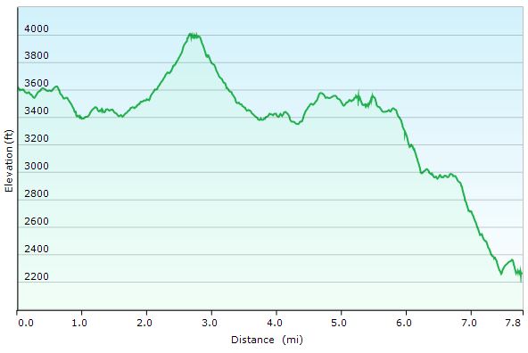
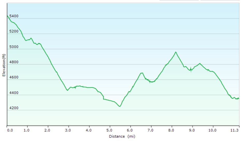
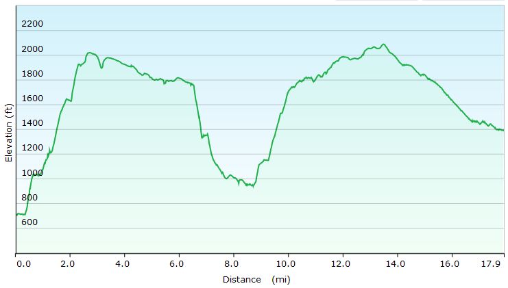
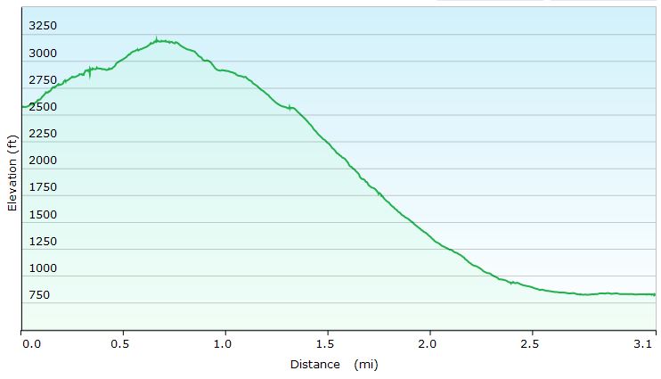
Starks Nest Hike Day 2 – Elevation Profile

Day 2 Mileage: 8 miles (5 round-trip for Mt Ellen, 3 for the hike out from Stark’s Nest)
Day 2 Gross Elevation Gain: 1,566′
Day 2 Gross Elevation Descent: 2,919′

Trip Totals
Grand Total Mileage: 11 Miles
Grand Total Elevation Gain: 3,067′

Notable Backpacking Gear Seen & Used

Notable Dog Backpacking Gear Seen & Used

Hiking Zion National Park – Camping & Backpacking in Southern Utah

Come along for 5 days of Hiking, Camping & Backpacking in Southern Utah’s Zion National Park.

For this adventure, I’ll be spending 5 days exploring Zion National Park with my friends Derrick, Dave, and Tayson from Outdoor Vitals and Randy from Outdoor.Detour on Instagram.  We’ll be doing 3 different backpacking / camping trips: A backcountry West Rim Backpacking Trip, Exploring & hiking the Frontcountry Zion National Park area while car camping in Springdale, Utah, and a backcountry camping trip on a top-down Narrows hike, ending at the Zion visitor’s center back in Springdale.

Note: All backcountry camping in Zion requires a permit. For details, visit the Zion NPS website.

Limited time offer from Outdoor VitalsGet the camping pillow I’m using in this video for FREE by clicking here.

Objective #1: Backcountry camp on Zion Canyon’s West Rim

Trailhead Used: West Rim Trailhead, Near Lava Point Overlook.
GPS coordinates N37° 22.899′ W113° 01.370′

West Rim Itinerary, Day 1

  • Park at the West Rim Trailhead parking area on the dirt service road near Lava Point.
    This is a gravel lot with parking for at least a half dozen cars or so.  It’s about a 40 minute drive from Springdale, Utah. The latter part of the drive is on a dirt road, but non 4wd vehicles should be fine with a bit of care.
  • Head south on the West Rim Trail
  • Setup Camp at West Rim campsite #4 GPS N37° 17.144′ W112° 59.030′

West Rim Hike Elevation Profile- Sintax77

West Rim Hike-In Mileage: 8 miles
West Rim Hike-In Gross Elevation Gain: 1,073

West Rim Itinerary, Day 2

  • Backtrack north on the West Rim Trail
  • Return to the trailhead parking lot near Lava Point.
  • Ghost town pit-stop in Grafton, Utah
  • Continue on to Springdale, Utah.
  • Check into the Quality Inn campground in Springdale, within walking distance of the Zion visitor center and park entrance.
  • Have some tacos at the Whiptail Grill, right next door to the campground. I got the “Fire Asada” tacos and they were great. If you like spicy food that’s actually spicy, I would highly recommend the Whiptail Grill. Heck, even if you don’t like spicy stuff – they have milder options, plus a fun & unique casual atmosphere as well. Oh, and the view is amazing too 🙂

Objective #2: Explore Zion National Park’s Frontcountry & Springdale, Utah.

Zion Frontcountry / Springdale Itinerary. Day 1

  • Wake up at the car campground in Springdale,
  • Take the free Zion shuttle, or a short walk north to the Zion National Park visitor center / entrance.
  • Take the Zion NP bus from the visitor center to Big Bend.
  • From the Big Bend bus stop, take the trail south along the Virgin River to Weeping Rock.
  • Road hike a bit along the Mount Carmel Highway to soak in the sights.
  • Hop another free Zion bus back towards the Springdale Visitor Center.
  • Explore Springdale, eat some ice cream at the Zion Candy Company on Zion Park Blvd.

Objective #3: Hike and Backcountry Camp the Narrows, from the Top Down.

Trailhead Used: Chamberlain’s Ranch Trailhead (aka Zion Narrows Upper Trailhead), Duck Creek Village, UT
GPS Coordinates N37° 23.121′ W112° 50.339′
Note: This was an end-to-end hike that required us to park a second vehicle at the Zion visitor center in Springdale to use as a shuttle back to the starting point.  The drive from the visitor center back to the Chamberlain’s Ranch Trailhead is around 80 minutes.

Zion NP – The Narrows, Top-down Hike Itinerary, Day 1

  • Park at the Narrows Upper Trailhead in Duck Creek, UT.
  • Head southwest on the trail, which is actually dirt road, closed off to vehicles, for the first 3 miles.
  • Continue to follow the trail along the Virgin River, through the Narrows.
  • This trail is very easy to follow, as it is literally the river. A majority of the time will be spent walking in the river bed in ankle deep to knee deep water depending on conditions, depending on current water-flow conditions.
  • Note for reference: The ccf reading during our trip was roughly 40 CCF.  Anything under 50 ccf is considered to be relatively ideal. Above 100 cfs, conditions can be difficult and hazardous. At 130 ccf, top-down narrows hikes will be closed. At 150 ccf, bottom up Narrows hikes will be closed.  During a flash flood, flows can exceed 1000 cfs.
  • Setup camp at the Narrows campsite #12.  N37° 19.982′ W112° 57.373′

Zion NP – The Narrows, Top-down Hike Itinerary, Day 2

  • Break camp and continue south along the Virgin River.
  • Exit the trail and catch the free Zion bus at the Temple of Sinawava shuttle stop.
  • Return to the Zion NP Springdale Visitor Center
  • Drive back to retrieve starting vehicle (~80 minute drive)

Notable Gear Seen:

Hiking the Standing Indian Loop – 3 Day Hammock Camping Trip

Join me for 3 days of Hiking, Hammock Camping & Backpacking along the Appalachian Trail in North Carolina’s Nantahala National Forest.  

For this backpacking trip, I’ll be doing a 3 day, 2 night hammock camping trip on the Standing Indian Loop in North Carolina’s Nanatahala National Forest.  The Standing Indian Loop is a 24 mile loop with a total elevation gain of 4,672′. The loop is made using a portion of the white blazed Appalachian Trail along with the blue blazed Lower Ridge Trail and Long Branch Trail. Campsites and water sources are plentiful on this loop, although many of the campsites are not located along water, so plan accordingly.  In my case, I chose two campsites that did have nearby water sources, for added convenience.

Route Overview – Standing Indian Loop – Sintax77

GPS Data for this trip and many others can be found on my Trip Data Page.  Includes full track data for each day, and way-points for campsites used / observed along the loop.

Gear Lists for this trip and others can be found on my Gear Lists Page or by using the links below.

Trailhead Used: Standing Indian Campground Information Area  – N35° 04.570′ W83° 31.707′
Just up the road from the Standing Indian Campground (car and RV camping), the information area permits overnight parking with spaces available for a half dozen cars or so.

Trails Used, Day 1
Park at the Backcountry Information area, just up the road from Standing Indian Campground.
Overnight parking for a half dozen cars or so available at the Info Center, just up the road from the main Standing Indian Campground area. (Overnight parking not available at the actual car camping area)
Lower Ridge Trail (located just behind the bulletin board)
Arrive at intersection with the Appalachian Trail, near summit of Standing Indian Mountain
Setup camp
This area has multiple campsite options spread of a large area.  A blue blazed spur trail departs the AT near the intersection and leads to a piped spring water source.

Day 1 Elevation Profile – Standing Indian Loop – Sintax77

Day 1 Mileage: 5 miles
Day 1 Gross Elevation Gain: 2,113′

Trails Used, Day 2
Head out Northbound on the Appalachian Trail (away from the spring spur trail)
Note: In the video I state on this morning that I was on the Appalachian Trail South. That was incorrect.  The AT winds around a bit in this area, and while my compass heading was indeed south, I was actually on the Appalachian Trail North.
Arrive at Betty Creek Gap and the depart the Appalachian Trail North on the
Blue Blazed Spur trail to legal camping.
While you will notice established campsites directly on the AT at Betty Creek Gap, a sign indicates that camping is currently not permitted in the area for restoration purposes.
Setup camp along the water at the end of the blue blazed Betty Creek Gap Spur Trail.
There are several campsites of varying size near the water. If they are taken – cross the water and continue about 30 yards to the gravel forest road. After crossing the road, you will immediately see more camping options in the woods beyond the road.

Day 2 Elevation Profile – Standing Indian Loop – Sintax77

Day 2 Mileage: 11 miles
Day 2 Gross Elevation Gain: 1,332′

Trails used. Day 3
Backtrack on the blue blazed Betty Creek Spur Trail to the AT intersection from yesterday.
Continue on the Appalachian Trail North.
Catch some views at the Albert Mountain Firetower (located directly on the AT)
Continue on the Appalachian Trail North
At the intersection, take the Long Branch Trail downhill, away from the AT.
Arrive back at the Backcountry Information Area.

Day 3 Elevation Profile – Standing Indian Loop – Sintax77

Day 3 Mileage: 8 miles
Day 3 Gross Elevation Gain: 1,227′

Trip Totals
Grand Total Mileage: 24 Miles
Grand Total Elevation Gain: 4,672′

Solo Hiking the Black Forest Trail – Hammock Camping Trip – 3 Days, 42 Miles

Join me for 3 days of Hiking, Hammock Camping & Backpacking on Pennsylvania’s Black Forest Trail.  

For this adventure, I’ll be doing a 3 day, 2 night solo backpacking trip in Pennsylvania’s Tiadaghton State Forest.  The Black Forest Trail is a 42 – 43 mile loop (depending on where you park and start from) with a total elevation gain of 8,550′.

Black Forest Trail Route Overview – Sintax77

GPS Data for this trip and many others can be found on my Trip Data Page.  Includes full track data for each day, and way-points for campsites used / observed along the loop.

I also highly recommend the Black Forest Trail Guidebook and Map.  I found the mile by mile information provided and overall quality to be great and very helpful.

For a detailed look at all of the gear used on this backpacking trip, check out my 9 lb ‘Stealth Backpacking Gear List’ post / video.

Trailhead Used: Pine Creek Rail Trail Access Area behind Wolfe’s General Store  – 41°28’15.6″N 77°30’05.8″W
Trailhead is on the other side of the auto bridge, behind the Hotel Manor inn / pub. Parking immediately at the trailhead is for day use only. No overnight parking is permitted in the hotel’s parking lot by the actual trailhead.

Black Forest Trail Full Loop Elevation Profile

Day 1
Park at the Slate Run Rail Trail parking lot
Head over the auto bridge and make a right.
Begin the loop at the Black Forest Trailhead, located in the lot behind Hotel Manor.
Head Counter Clockwise on the Black Forest Trail
Setup camp at an unestablished spot about a quarter mile past the crossing of Dyer Branch

Black Forest Trail Day 1 Elevation Profile- Sintax77

Day 1 Mileage: 16 miles
Day 1 Gross Elevation Gain: 2,989′

Day 2
Continue Counter-Clockwise on the Black Forest Trail
Setup camp at an establish spot along Naval Run creek.

Black Forest Trail Day 2 Elevation Profile- Sintax77

Day 2 Mileage: 15 miles
Day 2 Gross Elevation Gain: 3,182′

Day 3
Continue Counter-Clockwise in the Black Forest Trail
Return to the Slate Run Rail Trail Recreation Area Parking Lot

Black Forest Trail Day 3 Elevation Profile- Sintax77

Day 3 Mileage: 13
Day 3 Gross Elevation Gain: 2,953′

Budget Backpacking Trip – Camping in Tuscarora State Forest

Budget Backpacking & Camping with my Dog in Tuscarora SF.

For this hiking and camping trip, we’ll be using the exact gear seen on my previous ‘Budget Backpacking Gear List – Go Camping for Under $250‘ video.

Check out my live gear list on LighterPack.com for weights, prices, descriptions and product links.

Other Backpacking Topics Discussed on this Episode

  • Camping & backpacking with your dog.
  • Keto backpacking food options (hiking on a ketogenic diet – low carb, high fat)

Trailhead Parking
Hemlocks Natural Area Parking Lot, Tuscarora State Forest
40°15’18.7″N 77°38’02.8″W

Trails Used

  • Patterson Run Trail
  • Rim Trail
  • Hemlock Trail
  • Bushwack to legal campsite outside Hemlocks Natural Area

Denali’s Dog Backpacking Gear

Simplified Budget Backpacking Gear List:

Backpack

Shelter

Sleep System

Storage

  • Bear Bag Line (25′ guyline leftover from tarp setup, and small carabiner)
  • Bear Bag – 13 gal trash bag
  • Zip-lock Bag – Sandwich
  • Zip-lock Bag – Gallon

Cooking & Eating

Water Treatment & Storage

Tools

First Aid

  • First Aid Kit
    (Adhesive bandages, 1 gauze bandage, superglue, neosporin in straw tube, tealight wax candle, 6 doses benedryl, 10 doses ibuprofen, spare water bottle cap)
  • Sunscreen – 30 SPF 10ml bottle https://dutchwaregear.com/product/eye-dropper-bottles/
  • Fire Starter, DIY (dryer lint and wax, or cotton balls with vasoline)
  • Bug Spray – 100% Deet Mini Bottle 

Clothing (Packed, not worn. For spare, sleeping, rain)

  • Frogg Toggs Ultralight Rain Jacket 
  • Underwear – Synthetic (1 Pair)
  • Shorts
  • Shirt, Long Sleeve -Lt Wgt
  • Shirt, short sleeve
  • Hat, Beanie – Lt Wgt Fleece
  • Wool Socks – Lt Wgt (1 pair)

Lighting

Toiletries

  • Toilet Paper
  • Toiletry Kit
  • Wet Wipes
  • Hand Sanitizer

Additional Budget Backpacking Gear Options Discussed 

Approximate Costs for Each System

  • Tarp Camping version $248
  • Kelty tent version $317
  • Hammock Version $352
Clothing Worn (not included in cost)

Winter Camping in a Snow Trench – Sub Zero Bivvy Bag Adventure

Join Mike & I as we Attempt to Winter Camp in a Snow Trench at -15° F, Deep in the Woods of the White Mountains.

For this winter backpacking & Snow Camping adventure, we’ll be heading into the austere terrain of the Dry River Wilderness in New Hampshire’s White Mountains. Our main challenge for this adventure will be to sleep without the comforts of a tent of hammock.  Our goal is to use bivvy sacks to protect our sleeping bags from the elements as well as extend the range of our sleeping bags.  The latter of which is of particular importance because we’ll be packing in sleeping bags rated for around 15° to 20° F, in temperatures of around -15° F.  Our secondary objective will be to hit the summit of Mt Crawford, replete with stunning, 360° views of the White Mountains. Oh, and we’ve got some pretty fun backpacking food on the menu as well.  We’ll be camp cooking all “real food” on this trip, thanks to the sub-zero temps, no traditional dehydrated backpacking food.

Route Overview – Snow Trench Camping – Sintax77

Topics Covered in this Episode

  • Winter Campsite selection, via topographical maps, and well …pure luck.
  • Winter camping snow shovels (see gear list below for further details)
  • The complications of cooking backpacking food in sub-zero winter conditions.
  • Digging a winter camping shelter in the snow, along with tarp setup, should you be lucky enough to have one available (we did).
  • Building a fire on top of snow (not nearly as hard as you might think it is – even on the 6+ feet of snow that we had to deal with).
  • Sleeping in a snow trench with a SOL Escape Bivvy sack.
  • The balance of hitting a winter summit, versus well, not eating, hydrating or, you know -surviving.

Trailhead Parking

  • Davis Path Trailhead, Crawford Notch Rd, Bartlett, NH 03812
  • 44°07’08.1″N 71°21’15.1″W

GPS Data for this trip is available on the Trip Data Page, or by using this link for direct download: GPS Data – Snow Trench Camping Mt Crawford NH 2018 – Sintax77

Stats & Trails Used, Day One

  • Park at Davis Path Trailhead.
  • Head norht on the Davis Path Trail.
  • Setup camp in the flat area found around 2,500′ along the Davis Path Trail.

Elevation Profile Day 1 – Snow Trench Camping – Sintax77

Day 1 Mileage: 2.0 miles
Day 1 Elevation Gain: 1,725′

Stats & Trails Used, Day Two

  • Wake up, get a campfire going, and cook some soup for breakfast to get fueled up.
  • Grab some essential items (snacks, water, camera gear) and leave the majority of gear at camp to keep things fast and light for the upcoming high winds summit attempt.
  • Rejoin Davis Path Trail and head north.
  • At the junction, take the Mt Crawford Spur Trail, towards the summit of Mt Crawford.
  • Head back down the same way, to return to base camp and pack up the bulk our remaining items.

Elevation Profile Day 2 – Snow Trench Camping – Sintax77

Day 2 Mileage: 3.1 miles *0.65 miles to the summit of Mt Crawford, 2 miles from camp to the Davis Path Trailhead Parking Lot.
Day 2 Elevation Gain: 974′

Trip Totals
Total Elevation Gain: 2,699′
Total Mileage: 5.1 Miles

Notable Gear Used / Seen on this Backpacking Trip:

Pack
Backpack – EMS Longtrail 70 (2011 model)

Location
GPS Unit – Garmin Oregon 650

Cooking & Eating Utensils
Multi-fuel Camping Stove – Optimus Polaris Optifuel
Cook Pot, 1L – MallowMe
Cup – Vargo 450ml Titanium Cup
Spork, Plastic –  Sea to Summit Delta Spork

Seating
Byer of Maine Tri-Lite Camp Stool

Bivvy Bag System
SOL Escape Lite Bivvy Bag 
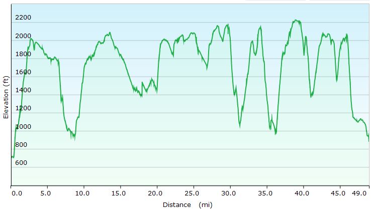
– Emergency Bivvy Sack for Survival and Camping

Sleep System
Sleeping Bag – Outdoor Vitals Mummy 15° Down Model

Shelter
Tarp – Hammock Gear Cuben Hex Tarp
Ground Cloth – Tyvek, long

Water Storage
Water Bottle – 40 Below 1 Liter Bottle w/ Bottle Boot

Light Sources

Headlamp – Olight H16 Wave LED Headlamp
12,000 lumen Mega Flashlight used to illuminate our campsite in sub-zero temps – Olight X7R Marauder

First Aid & SOS Messenger
Spot Messenger

Traction & Traversal
MSR Denali Ascent Snowshoes *No longer in production, I got them on Ebay. A modern equivalent would be something like the MSR Evo Ascent Snowshoe.
Kahtoola Micro Spikes *I didn’t end up using them, as I had my snowshoes on most of the time, but I always throw these in the pack for snow trips to deal with icy terrain.
Trekking Poles – CNOC Outdoors Carbon Fiber Vertex Trekking Poles

Snow Camping Tools
Camp Brand Snow Shovel *I’m not sure my model is in production anymore.  The closest current version seems to be the Camp Rocket Shovel.

Clothing
Mid Layer – Surplus Military Fleece
US Army Gen III Extreme Cold Weather Trousers
Gloves – Sealskinz Water Proof Ultra Grip Gloves
EMS Over-mittens w/ US Army Wool Gloves
Boots, Winter High Top Garmont GTX
Face mask / neck gaiter by Seirus Innovation