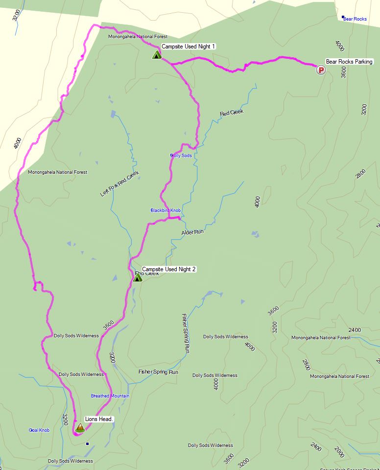
Hammock Camping on an Abandoned Mountain Farm – Quehanna Trail Ultralight Backpacking

Hammock Camping, Hiking & Ultralight Backpacking on the Quehanna Trail.

Yes, we’re once again camping in the rain. 🙂 For this overnight backpacking trip, I’ll be hiking a 22 mile loop in Pennsylvania’s Quehanna Wild Area, within the greater Moshannon State Forest.  Luckily, I learned from my last camping trip, and packed more adequate rain gear this time.

Itching for another hammock camping trip, I decided to have some fun and go back to more of an ultralight backpacking load-out for this adventure, clocking in at roughly 8.5 pounds base weight.

My full backpacking gear list, with weights & gear links is available on this lighterpacks.com link. A truncated notable backpacking gear list can be found at the bottom of this post.

Quehanna Short Loop – Route Overview – Sintax77

No permit is required to camp in the Quehanna Wild Area or the greater Moshannon SF.

Full GPS track data, including campsites, water sources, etc, for this trip and many others can be downloaded on my Trip Data Page.

Continue reading

Hammock Camping in the Rain – Cranberry Wilderness Backpacking w/ the Amok Draumr XL

3 Days of Hiking, Backpacking, & Rainy Hammock Camping in the Cranberry Wilderness using the Amok Draumr XL Hammock.

For this 3 day, 2 night spring backpacking trip, I’ll be hiking a 20 mile loop in West Virginia’s Cranberry Wilderness, part of the larger Monongahela National Forest. The specific area for this hike, located between the Williams River and the Cranberry River, is commonly referred to as the Cranberry Backcountry.

Each of the 3 days will be comprised of three different “vibes”. Day one will mostly be a lowlands hike in the woods, day two will be primarily along the the beautiful Cranberry River, and day three will be a mossy, higher elevation ridge hike along Kennison Mountain.

With a new Amok Fjol XL tarp in hand to thwart the forecast of rain, each night will be spent hammock camping and testing the new Amok Draumr XL hammock, which Amok kindly sent for evaluation.

Route Overview Cranberry River Loop – Sintax77

No permit is required to camp in the Cranberry Wilderness, but there are rules and regulations regarding backcountry camping. You can find more information on the USFS Cranberry Wilderness website here.

Full GPS track data, including campsites, water sources, etc, for this trip and many others can be downloaded on my Trip Data Page.

Continue reading

Hiking Halfmoon Mountain – Camping & Backpacking in West Virginia

Solo Backpacking, Hiking, & Camping with my Dog on the Halfmoon Mountain Loop in West Virginia.

For this 2 day, 1 night spring backpacking trip, I’ll be hiking a 10.5 mile loop in the George Washington National Forest.

Route Overview – Halfmoon Mountail Loop – Sintax77

No permit is required to camp in the George Washington National forest, but there are rules and regulations regarding backcountry camping. You can find more information on the George Washington & Jefferson National Forest website here.

Full GPS track data, including campsites, water sources, etc, for this trip and many others can be downloaded on my Trip Data Page.

Continue reading

Winter Camping with a Pulk Sled – Adirondacks Deep Snow & Icy Summits

Join us for 2 days of winter camping, backpacking & snowshoeing with a pulk sled in the deep snow of the Adirondack mountains.

For this winter camping adventure, we’ll be using a DIY pulk sled to setup up a base camp in the Giant Mountain Wilderness.  Day one will be dedicated to building camp and settling in, followed by a summit attempt of Giant Mountain on day two.

Our winter pulk sled will be used for group items such as campfire cooking gear, stoves, steaks and other food, additional firewood, our tent, etc.  In addition to the sled, Mike, Frank and myself each have a backpack for personal items such as cold weather clothing options and other gear. A list of notable gear can be found at the end of this post.

Route Overview – Roaring Brook to Giant Mt – Sintax77

No permit is required to camp in the Giant mountain wilderness, but there are rules and regulations regarding backcountry camping. You can find more information on the Adirondacks Park Giant Mountain Wilderness website here.

Full GPS track data, including campsites, water sources, etc, for this trip and many others can be downloaded on my Trip Data Page.

Continue reading

Winter Hammock Camping in the Smoky Mountains

Join me for 3 days of Winter Hammock Camping, Backpacking & Hiking in the Smoky Mountains. 

For this winter camping adventure, I’ll be doing a Gregory Bald Loop Hike, incorporating campsite 13 Sheep Pen Gap, campsite 113 Birch Spring Gap, and a hike to the Shuckstack Fire Tower.  This is my second backpacking trip to the Smokies, but due to the shorter winter days, ice, and snow, I’ll be slowing the pace down a bit compared to my previous hammock camping experience there.

Route Overview – Gregory Bald Loop – Sintax77

A backcountry permit is required for all campsites in this area. You can reserve them for $4 per night on the Smoky Mountains National Park website here.

Full GPS track data, including campsites, water sources, etc, for this trip and many others can be downloaded on my Trip Data Page.

Continue reading

Hiking the CDT Loop – Colorado Backpacking & Camping Trip

https://youtu.be/58PJ2Kvlroc

4 Days of Hiking, Camping & Backpacking on Colorado’s Continental Divide Trail in the Rocky Mountain National Forest.

For this backpacking trip, we’ll be doing a 4 day, 3 night camping trip on a section of the Continental Divide Trail in Colorado’s Rocky Mountain National Park.  Sometimes referred to as the “CDT Short Loop”, this backpacking loop is a 29 mile mile circuit with several different access point options. In our case, we parked at the Green Mountain trailhead, just past the RMNP Kawuneeche visitor center and park entrance by Grand Lake, CO.  The 2 mile Green Mountain trail provided us access to the CDT and brought our mileage for the loop up to 33 miles.

CDT Loop Route Overview – Sintax77    

GPS Data for this trip and many others can be found on my Trip Data Page.  Includes full track data for each day, and way-points for campsites used, water sources, etc along the loop.

Trailhead Used: Green Mountain Trailhead, RMNP, Grand Lake, CO  – 40°18’26.7″N 105°50’28.7″W
This parking area is only a few miles into the park & provides overnight parking for plenty of vehicles. A park entrance pass and wilderness camping permit is required (contact the Kawuneeche Office for details and availability)

Trails Used, Day 1
Park at the Green Mountain Trailhead.
Green Mountain Trail
Junction with Tonahutu Creek Trail (CDT)
Continue north on the Continental Divide Trail
Setup camp at Sunset camp (Elevation 9,498′)
This is a single group tentsite that must be reserved via permit.

CDT Loop Day 1 Elevation Profile – Sintax77

Day 1 Mileage: 4 miles
Day 1 Gross Elevation Gain: 974′

Trails Used, Day 2
Continue on the Tonahutu Creek Trail (CDT)
Stock up on water before heading up the ridge (last chance at N40° 19.579′ W105° 43.701′)
Continue on Tonahutu Creek Trail (CDT) through Ptarmigan Pass
Junction North Inlet Trail / Flattop Mountain Trail
Head south on the North Inlet Trail (CDT)
Junction North Inlet / Lake Nanita Trail
Head South on the Lake Nanita Trail
Setup camp at Pine Marten Camp (Elevation 9,568′)
These are two separate single group tentsites that must be reserved via permit.

CDT Loop Day 2 Elevation Profile – Sintax77


Day 2 Mileage: 14 miles
Day 2 Gross Elevation Gain: 3,074′

Trails used. Day 3
Dayhike to Lake Nokoni by heading south on the Lake Nanita Trail
We only went to the first lake, Nokoni, due to weather and time issues, but there is a second lake, Nanita, about .75 miles further up the trail.
Backtrack to camp and grab packs.
Return to Junction with North Inlet Trail
Continue west on the North Inlet Trail (CDT)
Setup camp at Twinberry Camp # 2 (Elevation 8,661′)
These are two separate single group tentsites that must be reserved via permit.

CDT Loop Day 3 Morning Lake Hike Elevation Profile – Sintax77

CDT Loop Day 3 Elevation Profile – Sintax77

Day 3 Mileage: 9.6 miles (4 miles round trip for lake hike, 5.6 miles on the CDT Loop)
Day 3 Gross Elevation Gain: 1,414′ (Almost all of this was from the lake hike excursion)

Trails used. Day 4
Continue west on the North Inlet Trail (CDT)
Arrive at the North Inlet Trailhead
Beyond the parking lot, you’ll find the Tonahutu Trailhead
Head north on the Tonahutu Creek Trail
Junction with Green Mountain Trail
Return to Green Mountain Trailhead Parking Lot

CDT Loop Day 4 Elevation Profile – Sintax77

Day 4 Mileage: 9.5 miles
Day 4 Gross Elevation Gain: 1,204′
Trip Totals
Grand Total Mileage: 37 Miles
Grand Total Elevation Gain:  6,666′
Note: 4 miles and 1,414′ can be attributed to our day 3 lake hike)
Notable Backpacking Gear Seen / Discussed