Sara’s Shocking Budget Backpacking Gear Challenge

Sara goes Backpacking to try out some $30 Amazon Camping Gear.

For this early spring backpacking trip, Sara and I headed to an upper elevation section of Arizona’s Coconino National Forest, about 30 miles southwest of Sedona. Despite it’s close proximity to the much hotter and drier desert like climate of Sedona, the 7,500 foot elevation and abundant snow melt provided an environment surprisingly similar to hiking back on our native east coast. Yes, you can actually find snow, pine trees and abundant streams in Arizona!

To get our dose of 20 degree cooler temps, along with some pockets of remaining snow, we chose to hike a section of the larger Cabin Loop Trail system.  This loop utilizes several different local trails.  One of which is the Arizona Trail, a roughly 800 mile long distance trail that traverses the entire length of the state from the Mexican border to the Utah state line.

This particular region of the AZT gave us some awesome camping opportunities right along the Mogollon Rim with stunning views down into the valley some 2,000 feet below.  To be fair though, we didn’t really spend too much time on the actual AZT.  We chose instead to create our own route along the rim, in search of drinking water and those aforementioned great views.

For gear on this trip, Sara decided to pick up several new pieces budget backpacking to test out – a sleeping pad, two person tent, and two person sleeping bag complete with pillows.  She found each of these for about $30 a piece on Amazon.  But would they get the job done for an overnight backpacking trip with our dog in tow?  Well, there’s only one way to find that out, I guess.

Oh, and the last mile or so of road to the trailhead was impassable due to a blockade of remaining snow, so that made for an interesting start 🙂

Trailhead Used
Battle of Big Dry Wash Historical Landmark & AZT Trailhead
Payson, AZ 85541
34°27’15.4″N 111°15’02.5″W

Continue reading

Camping in Heavy Rain – Pinchot Trail South Loop Backpacking Trip

Join Sara and I for some Spring Backpacking, Camping in the Rain, and Trail Cooking on the Pinchot Trail southern loop.


FTC Disclosure: This post contains affiliate links, which means I may receive a commission for purchases made through some of my links.

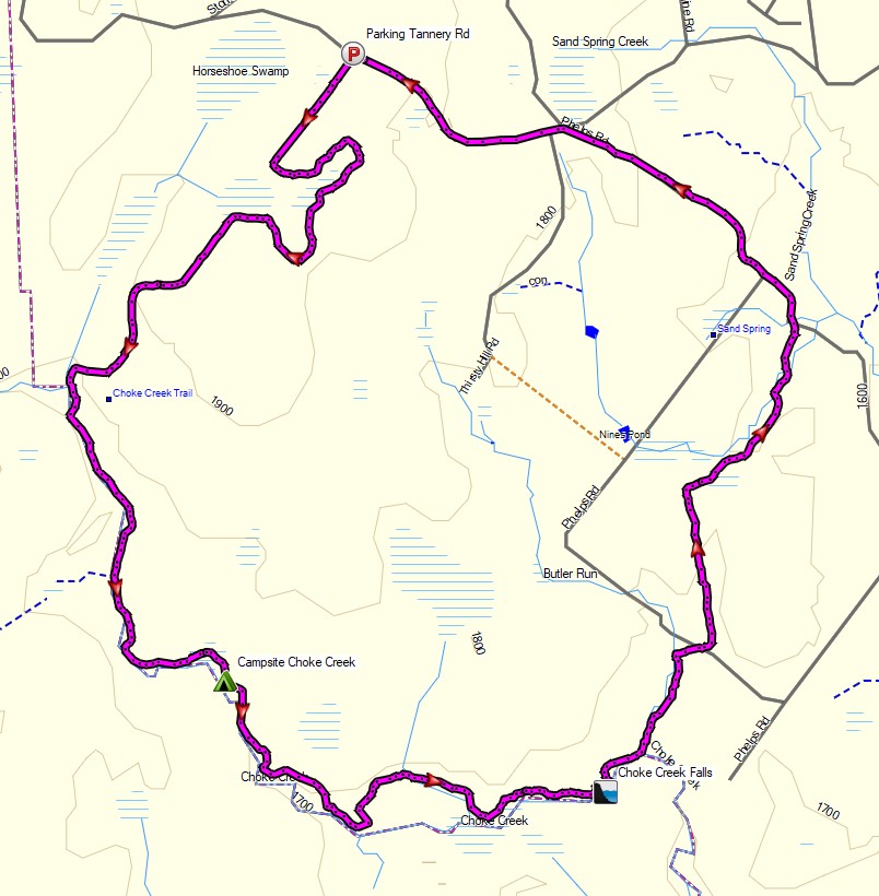
For this early spring camping trip, my wife Sara and I set out to do some backpacking  with our dog and explore Pennsylvania’s Pinchot Trail southern loop.  I had done the northern loop a couple of weeks before and it was quite nice, so I was looking forward to seeing what this new section had to offer.

For shelter, we packed in our 4 person tent as well as a huge tarp to give us some extra living space during the rain storm that was forecasted to hit in the afternoon and turn into snow by the next morning.

The bottom of the Pinchot Trail South loop runs along Choke Creek, which offers a string of 6 or so beautiful waterside campsites over the course of a mile or so. Legend has it that the last of those campsites is the most picturesque, so our goal was to hike in a few miles to the creek and get to that coveted campsite before the afternoon rain started. If the weather broke early, we would aim to take one of the earlier campsites.

Route Overview – Pinchot Trail South Backpacking Loop – Sintax77

Continue reading

Honey I Forgot the Tent – When Backpacking Goes Wrong

Hiking, Backpacking and an attempt at Tent Camping in the Rain in Virginia’s George Washington National Forest.

FTC Disclosure: This post contains affiliate links, which means I may receive a commission for purchases made through some of my links.

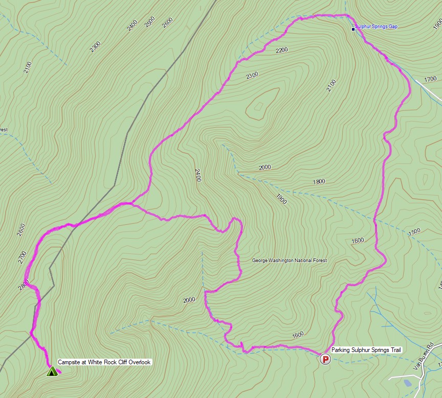
For this overnight backpacking trip, Sara and I decided to do some summer backpacking with our dog on a section of Great North Mountain, a 50 mile long mountain ridge that runs along the border of West Virginia and Virginia.

Despite the threat of a quickly approaching storm, we decided to forge ahead with a modest 3 day, 7 mile backpacking trip. Our plan was to keep the itinerary relatively simple in hopes that we could get to camp in time to beat the rain. And then we ran into a slight complication. Actually, it wasn’t slight at all. It was quite possibly the biggest backpacking mistake I’ve ever made…

White Rock Cliff Loop Virginia – Route Overview – Sintax77

There is no parking fee or backcountry camping permit required for this section of the George Washington and Jefferson National Forest.  More details regarding dispersed camping can be found on the official GWJNF website here.

Full GPS track data, including campsites, water sources, etc, for this trip and many others can be downloaded on my Trip Data Page.

This trip video was sponsored by RevolutionRace. Use code 15sintax to get 15% off their entire Amazon store site until 9/11/21 here.

Trailhead Used: Sulphur Springs Parking Area Forest Road 1725
38°58’31.4″N 78°34’03.5″W
FR1725, Maurertown, VA 22644

Continue reading

Our Best Campsite Yet – Tongue Mountain Backpacking Trip

Camping and Backpacking in the Adirondacks on the Tongue Mountain Range.


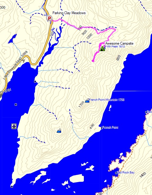
For this overnight backpacking trip, Sara, Denali and I headed up to New York for some laid back camping on the summit of Fifth Peak Mountain, overlooking Lake George. The Tongue Mountain Range is a 3 mile long peninsula, so named because it looks like a tongue jutting out into the 32 mile long Lake George. Our plan was to hike in a few miles to the top of the range and hit the first peak at the top of the peninsula to set up for an afternoon and night of relaxed camping. The next morning we would have the option to either continue along the 13 mile long Tongue Mountain loop, or hike back out the same way we came in.

We had our dog with us, so we decided to return to tent camping for this trip. We did finally upgrade our previous budget tent to a four person (or 2 plus a dog) Marmot Limelight 4p tent though. And as I usually do for trips with my wife and dog, I packed in a massive backpack full of comfort camping gear and fun camp food. A more detailed gear list can be found at the bottom of this post.

Thank you to Anker for sponsoring this video.  My viewers can get $100 off the Anker Powerhouse II 800 by using this link on Amazon or direct from Anker.

Tongue Mountain Adirondacks - Route Overview - Sintax77
Tongue Mountain Adirondacks – Route Overview – Sintax77

There is no permit required for backcountry camping on the Tongue Mountain Range, but there are certain rules and regulations.  You get find more info on the official NY DEC website here.

Full GPS track data, including campsites, water sources, etc, for this trip and many others can be downloaded on my Trip Data Page.

Continue reading

Camping in the Rain – Sara’s Secret Campsite

Backpacking, Camping in the Rain, and Trail Cooking in Virginia’s Shenandoah National Park.

FTC Disclosure: This post contains affiliate links, which means I may receive a commission for purchases made through some of my links.

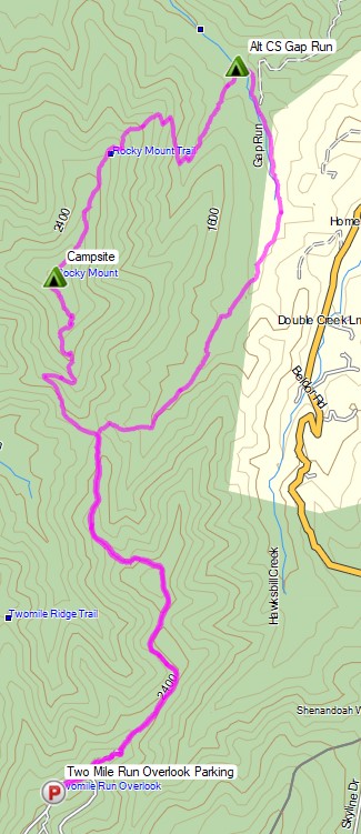
For this overnight backpacking trip, Sara, Denali and I decided to do some early spring camping on the Shenandoah’s Rocky Mount Trail and Gap Run trail.  Combining the two would create a roughly 10 mile backpacking loop with sweeping mountain views on the first day, and peaceful babbling brooks on the second.

We had our dog with us on this trip, so we returned to using our budget tent to keep the group together.  The weather on day one had a 100% chance of rain, so I also brought along a huge tarp to give us a common area with a view of the impending storm without being stuck inside the tent the whole afternoon. More details on our gear can be found at the bottom of this post.

Off course all of this would depend on whether or not we could find Sara’s elusive secret camping spot before the rain began to really come down…

Thank you to Private Internet Access for sponsoring this video.  My viewers can get complete digital privacy for less than $3 a month and 3 months free by using this link.

Shenandoah Rocky Mount Loop – Route Overview – Sintax77

There is an entrance fee for Shenandoah National Park to access Skyline drive.  Backcountry camping is free, but you need to self register for a permit at the entrance station.  You can find more information on the official SNP website here.

Full GPS track data, including campsites, water sources, etc, for this trip and many others can be downloaded on my Trip Data Page.

Continue reading

Fall Camping in Dolly Sods – Foliage Peaking and Sleeping Pads Leaking

Join Sara and I for 3 Days of Camp Cooking, Hiking, & Backpacking in the Dolly Sods  Wilderness.

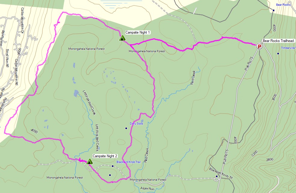
For this 3 day, 2 night backpacking trip, Sara, Denali and I decided to do some fall foliage camping in West Virginia’s Dolly Sods Wilderness, part of the larger Monongahela National Forest. Dolly Sods is located in the Allegheny Mountains on the highest plateau east of the Mississippi river and features some of the most varied and scenic terrain available to hikers in the Mid-Atlantic region.

We had our dog with us on this trip, so we decided to give tent camping a go this time around to keep us all together in one spot.  I also decided to totally throw lightweight backpacking out the window for this trip, so I brought along my Fjallraven Kajka 75 backpack and stuffed it to the gills with various backpacking gear, just to have a little fun and switch things up a bit (gear list at end of post).  This decision was made easier by the fact that we were starting at Bear Rocks trailhead, which is already high up on the plateau with minimal elevation changes.

Campsites and great views are fairly abundant in Dolly Sods, so our general plan was to keep the mileage low and focus on a relaxed hiking pace, fun backpacking food and camp cooking.  It was the perfect recipe for a laid back camping trip.  Other than the whole leaking sleeping pad situation to make things more interesting…


Route Overview – Dolly Sods Fall Backpacking Loop – Sintax77

No permit is required to camp in the Dolly Sods Wilderness, but there are rules and regulations regarding backcountry camping. You can find more information on the USFS Dolly Sods website here.

Full GPS track data, including campsites, water sources, etc, for this trip and many others can be downloaded on my Trip Data Page.

Continue reading